Geographic Region: BOLIVIA
Feature: LAGO COIPASA, VOLCANOES
|
Geographic Region: BOLIVIA Feature: LAGO COIPASA, VOLCANOES |
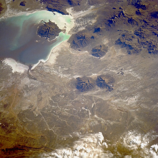 |
| STS026-040-064 Altiplano, Bolivia October 1988 The high plateau region (altiplano) of western Bolivia and southern Peru, averaging about 12 000 feet (3650 meters) above sea level, and its associated basin are bordered by the Cordillera Oriental to the east and the Cordillera Occidental to the west. The details in this southwest-looking photograph are typical of the nonvegetated, generally flat, arid surface of the altiplano in southwestern Bolivia. The altiplano's high, encircling mountain ranges, formidable physical barriers to weather systems, allow very limited quantities of precipitation during the summer months. The north-to-south drainage pattern shows flow into Lake Coipasa from the intermittently flowing Lauca River and its many tributaries. Along the western third of the photograph is a very pronounced volcanic landscape comprising individual volcanoes and clusters of volcanoes, which in terms of density and altitude are fairly typical of many areas of the Cordillera Occidental. The volcanic peaks range from 16 000 feet (4900 meters) to more than 19 000 feet (5800 meters). Even though Lake Coipasa had water when this photograph was taken, it is frequently called Salar (dry lakebed) de Coipasa because of insufficient flow from the river. Evaporation is a major cause of water loss for the entire region. (See photograph SL3-115-1911 for a synoptic view of this same general area in which Salar de Coipasa is a much smaller lake with very little water. Based on reviews of recent Shuttle photographs, this area of the altiplano seems to be experiencing at least a short-term drought because little or no water can be seen in the dry lakebeds.) |
| Images: | All Available Images Low-Resolution 146k |
|
| Mission: | STS026 |
|
| Roll - Frame: | 40 - 64 |
|
| Geographical Name: | BOLIVIA |
|
| Features: | LAGO COIPASA, VOLCANOES |
|
| Center Lat x Lon: | 19S x 68W |
|
| Film Exposure: | N | N=Normal exposure, U=Under exposed, O=Over exposed, F=out of Focus |
| Percentage of Cloud Cover-CLDP: | 15 |
|
| Camera:: | HB |
|
| Camera Tilt: | 43 | LO=Low Oblique, HO=High Oblique, NV=Near Vertical |
| Camera Focal Length: | 250 |
|
| Nadir to Photo Center Direction: | S | The direction from the nadir to the center point, N=North, S=South, E=East, W=West |
| Stereo?: | N | Y=Yes there is an adjacent picture of the same area, N=No there isn't |
| Orbit Number: | 52 |
|
| Date: | 19881002 | YYYYMMDD |
| Time: | 211652 | GMT HHMMSS |
| Nadir Lat: | 16.6S |
Latitude of suborbital point of spacecraft |
| Nadir Lon: | 67W |
Longitude of suborbital point of spacecraft |
| Sun Azimuth: | 270 | Clockwise angle in degrees from north to the sun measured at the nadir point |
| Space Craft Altitude: | 164 | nautical miles |
| Sun Elevation: | 15 | Angle in degrees between the horizon and the sun, measured at the nadir point |
| Land Views: | VOLCANO, MOUNTAIN, SALAR, PLATEAU |
|
| Water Views: | LAKE |
|
| Atmosphere Views: | |
|
| Man Made Views: | |
|
| City Views: | |
|
Associated Photos in Sequence:  Photo #: STS057-99-65 Photo #: STS057-99-65Description: PERU/BOLIVIA-1993; L. TITICACA, L. POOPO REGION-SYNOPTIC VIEW Sequence ID: 6A  Photo #: SL3-115-1911 Photo #: SL3-115-1911Description: BOLIVIA, LAKE POOPO-1973; LAKE LEVEL Sequence ID: 6B  Photo #: STS51J-144-23 Photo #: STS51J-144-23Description: BOLIVIA, LAKE POOPO-1985; LAKE LEVEL Sequence ID: 6C  Photo #: STS026-40-64 ** Currently displayed photo ** Photo #: STS026-40-64 ** Currently displayed photo ** Description: BOLIVIA, LAKE POOPO, LAKE COIPASA-1988; LAKE POOPO LAKE LEVEL Sequence ID: 6D  Photo #: STS032-88-69 Photo #: STS032-88-69Description: BOLIVIA, LAKE POOPO-1990; LAKE LEVEL Sequence ID: 6E  Photo #: STS048-72-49 Photo #: STS048-72-49Description: BOLIVIA, LAKE POOPO-1991; LAKE LEVEL CHANGES Sequence ID: 6F  Photo #: STS064-91-22 Photo #: STS064-91-22Description: BOLIVIA, LAKE POOPO-1994; DECREASING LAKE LEVEL Sequence ID: 6G  Photo #: STS073-735-47 Photo #: STS073-735-47Description: BOLIVIA, LAKE POOPO-1995; LAKE IS DRY Sequence ID: 6H | ||
| NASA Home Page |
JSC Home Page |
JSC Digital Image Collection |
Earth Science & Remote Sensing |
|
This service is provided by the International Space Station program and the JSC Earth Science & Remote Sensing Unit, ARES Division, Exploration Integration Science Directorate.

|