| |
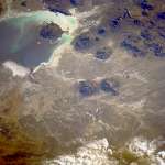
STS048-72-49 Lake Poopo, Bolivia September 1991
Lake Poopo (also known as Lake Aullagas) in the Altiplano (high plains) of Bolivia stands out in this low-oblique, north-looking photograph. When full, this salt lake covers 965 square miles (2500 square kilometers). The lake is located more than 11 000 feet (3350 meters) above sea level and has an average depth of only 10 feet (3 meters). The lake is fed by the Desaguadero River (brown sediment-laden water at the north end of the lake) that receives its water from Lake Titicaca to the north. Lake Poopo is drained at its south end by a small river that follows a westward course and drains into the Salar de Coipasa (not visible in the photograph). During the melting of the last Andean ice age some 11 000 to 13 000 years ago, Poopo was part of a much larger glacial lake called Ballivian. This massive lake also included Salar de Coipasa, Salar de Uyuni, and Lake Titicaca. In recent years, water levels in Lake Poopo have been receding as evidenced by the bright white shoreline surrounding most of the lake. Water levels have also been receding at Lake Titicaca, thereby decreasing the flow of water into the Desaguadero River. Much lake water is also lost through evaporation caused by intense sunshine and strong winds. The marshy, dark area of former Lake Ura is visible north of the lake. The shallow waters of Lake Poopo rich in nutrients, are the wintering grounds for migrant wading birds from North America. | |


 Photo #: STS057-99-65
 Photo #: SL3-115-1911
 Photo #: STS51J-144-23
 Photo #: STS026-40-64
 Photo #: STS032-88-69
 Photo #: STS048-72-49 ** Currently displayed photo **
  Photo #: STS064-91-22
 Photo #: STS073-735-47