Frequently Asked Questions
On this page:
Conditions of use of astronaut photographsHow should I credit when using astronaut photography and time-lapse videos?
How do I search for a particular feature in your database?
Why is there no data available for my specific location?
Why do you have the old country title associated with some images?
How much detail is in astronaut photography?
What is the scale of this astronaut photograph?
Why do you not have any images of the poles?
What are "nadir", "near vertical", and "oblique" views?
What is the focal length and what does it have to do with the image footprint on the Earth?
What is the sun azimuth?
Can you explain the cloud cover percentage choices?
What does it mean when an astronaut photograph is "cataloged"?
What is the sun elevation angle and how is it calculated?
What does "ISS paralleling the terminator" mean?
What are the different choices of cameras?
What are the different choices of camera film and formats?
North is not at the top of the photo. Is there some mistake?
Why can you not see stars or galaxies in the photographs that show the curvature of the Earth and part of the black background of space?
Is it true that the Great Wall of China is the only human-made object that can be seen from space?
Where can I find a photograph of the whole Earth as seen from space?
Do the photos show the view exactly as it appears to the naked eye out of the spacecraft?
What kind of film is used?
How do I know if an image on the website is the best possible quality?
What kind of color correction is used on images taken with a digital camera?
How does the resolution compare with data from robotic satellites like Landsat or SPOT?
How does pixel size or instantaneous field of view relate to the size of objects that can actually be distinguished in a space photograph?
Since astronauts are traveling so fast in orbit, why don't the photographs look smeared?
How can I use astronaut photographs in scientific research?
What does the "Features from Machine Learning" checkbox do?
What does the "Include Panorama Imagery" checkbox do?
What are cloud masks that are available for some imagery?
How are cloud masks generated?
What do all of the fields in the Display Record page mean?
Missions used in the Database
Time to Position/Position to Time - Fields
Time to Position/Position to Time - Vectors
How is the planetary body determined for each photo?
Conditions of use of astronaut photographs
To use astronaut photography of Earth accessed through this website, please state "Image courtesy of the Earth Science and Remote Sensing Unit, NASA Johnson Space Center" or "Video courtesy of the Earth Science and Remote Sensing Unit, NASA Johnson Space Center" as appropriate. We recommend that the caption for any photograph published include the unique photo number (Mission-Roll-Frame), and our website (eol.jsc.nasa.gov) so that others can locate or obtain copies when needed. For videos, we recommend that the caption published include the title and a link to the video page on our website. We always appreciate notification of beneficial uses of astronaut photography of Earth and information on your applications. This will help us continue to maintain these services for the public. Send e-mail to jsc-earthweb@mail.nasa.gov.
As a government entity, NASA does not "license" the use of NASA materials or sign license agreements. The Agency generally has no objection to the reproduction and use of these materials (audio transmissions and recordings; video transmissions and recording; or still and motion picture photography), subject to the following conditions:
- NASA material may not be used to state or imply the endorsement by NASA or by any NASA employee of a commercial product, service, or activity, or used in any manner that might mislead.
- NASA should be acknowledged as the source of the material. For astronaut photography of Earth accessed through this website, please state “Image courtesy of the Earth Science and Remote Sensing Unit, NASA Johnson Space Center" or "Video courtesy of the Earth Science and Remote Sensing Unit, NASA Johnson Space Center" as appropriate. We recommend that the caption or supporting materials used for any photograph published include the unique photo number (Mission-Roll-Frame), and our website (eol.jsc.nasa.gov) so that others can locate or obtain copies when needed. For videos, we recommend that the caption published include the title and a link to the video page on our website. We always appreciate notification of beneficial uses of astronaut photography of Earth and information on your applications. This will help us continue to maintain these services for the public. Send e-mail to jsc-earthweb@mail.nasa.gov.
- It is unlawful to falsely claim copyright or other rights in NASA material.
- NASA shall in no way be liable for any costs, expenses, claims, or demands rising out of the use of NASA material by a recipient or a recipient's distributees.
- NASA does not indemnify nor hold harmless users of NASA material, nor release such users from copyright infringement, nor grant exclusive use rights with respect to NASA material.
- NASA material is not protected by copyright unless noted. If copyrighted, permission should be obtained from the copyright owner prior to use. If not copyrighted, NASA material may be reproduced and distributed without further permission from NASA.
- If a recognizable person, or talent (e.g., an astronaut or a noted personality engaged to narrate a film) appears in NASA material, use for commercial purposes may infringe a right of privacy or publicity. Therefore, permission should be obtained from the recognizable person or talent. If the proposed use of the NASA material could be viewed as a commercial exploitation of that person. However, if the intended use of NASA material is primarily for communicative purposes, i.e., books, newspapers, and magazines reporting facts of historical significance (constitutionally protected media uses), then such uses will generally be considered not to infringe such personal rights.
- Some NASA audiovisual material may incorporate music or footage, which is copyrighted and licensed for the particular NASA work. Any editing or otherwise altering of the work may not be covered under the original license, and therefore would require permission of the copyright owner.
- NASA audiovisual material may include visible NASA identifiers (e.g., the name of the vehicle and the NASA Insignia or Logotype in photographs or film footage of Space Shuttle vehicles). Use of such materials is generally non-objectionable, provided the NASA identifiers appear in their factual context.
- NASA's emblematic designs are protected by statute and implementing regulations, specifically, 14 CFR Part 1221, Subpart 1221.1 -- NASA Seal, NASA Insignia, NASA Logotype, NASA Program Identifiers, NASA Flags, and the Agency's Unified Visual Communications System.
How should I credit when using astronaut photography and time-lapse videos?
You are welcome to use our photos or videos, for which NASA does not maintain a copyright. If the images are used in publications, websites, formal presentations, etc., our requests are:
- That you credit the Earth Science and Remote Sensing Unit, NASA Johnson Space Center as the source of the information.
- That you link to our homepage or otherwise list the URL so that other web users can find the base material.
- That you let us know about your links. We are glad that you are finding the photos or videos to be useful for educational purposes, and would like to see the results.
- If used in a publication, please send us a complete citation or a .PDF copy (if possible), when the work is in hard copy for our records.
How do I search for a particular feature in your database?
We have a number of tools on our website that allow you to search for photos, browse low resolution images, and download digital versions of many images at various resolutions. You can find these tools here. Among these tools are also an uncataloged image search tool that may be useful for queries of a specific area with latitude/longitude coordinates. Images obtained using this option will have no center point defined and no descriptive metadata, so the user would need to identify the ground location of the image.
If, after using our search tools, you have specific questions about finding the exact photo you need, feel free to contact us with those questions. If you are interested in purchasing a photo that you find, or need a custom resolution or product, you may do so by contacting the Johnson Space Center Communications team. Use the contact information below for prices, printing options and turnaround times. Please be aware that this process can take up to 5 working days.
NASA JOHNSON SPACE CENTER
JSC Communications
jsccommu@mail.nasa.gov
2101 NASA Parkway
Houston, TX 77058
Phone (281) 483-5111
Please also note that astronaut photograph data may not exist for a given location on the Earth, or for a desired lighting or viewing perspective, and therefore may not be represented in our database.
Why is there no data available for my specific location?
The astronauts frequently take numerous images in addition to their established science targets, so it is possible that an image of your region of interest will be acquired in the future. If you are unable to find the images you need through our cataloged search options, please feel free to browse through our uncataloged imagery database. The images will not be geolocated or have associated features identified.
Why do you have the old country title associated with some images?
In cataloging new imagery, we use the names of the current republics in the geographic name field. Over the period of human spaceflight, a number of countries have changed names, united and divided. Our database uses the geographic name that was appropriate when the photograph was taken.
How much detail is in astronaut photography?
There are limitations to how much detail can be photographed by astronauts. The most detail we have observed is 3-meter pixels, meaning that each dot on the image is equal to 3 meters on the ground. In these most detailed photos, you can see neighborhood streets (unless they are heavily tree-lined) clear; individual houses and other buildings may be visible, but will likely not be sharply defined or have visible details. To find detailed images in our database, visit the Find Photos page and choose a focal length of at least 800mm.
What is the scale of this astronaut photograph?
This information is available for a large number of images in our database. In order to calculate the width and height of the image, we have to know the nadir location (coordinates the ISS is over at the time) as well as the center point (latitude and longitude of the center of the image), and the look angle must not be too oblique. For all the records in our database that meet these requirements, a button appears on the record display page that says "Calculate photo footprint". By clicking this button, you get a display that shows the distance across the image in meters, and the locations of a locator ellipse (in latitude and longitude).
Why do you not have any images of the poles?
The International Space Station uses a "circular" orbit with relatively low inclination angles relative to the Earth's equator. What this means is that the Space Station orbit track never crosses either the North or South polar regions. It is possible for astronauts to obtain oblique views of both the Arctic and Antarctic regions at the limits of the orbit track, but usual conditions of low light and poor weather limits their level of detail and usefulness. Other satellites such as Landsat are in Sun-synchronous, near-polar orbits that are greatly inclined relative to the equator. Such an orbit allows coverage of both polar regions. For more information, see our Space Station Orbit Tutorial.
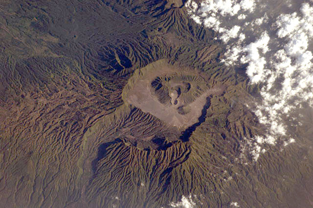
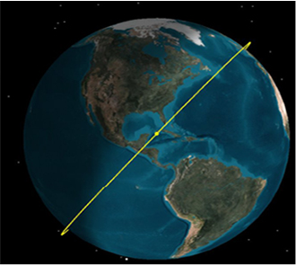
What are "nadir", "near vertical", and "oblique" views?
Unlike robotic satellites, which look Earthward with a fixed geometry, the human astronaut can look out the window of the spacecraft at any angle. If the astronaut looks toward the nadir of the orbit, he or she is looking directly down at the Earth with no tilt angle. If the astronaut looks at some angle off the orbit track, he or she is looking at an oblique angle. Oblique photographs are classified as high oblique if the horizon or atmospheric limb can be seen. Photographs are classified as low oblique if they are intermediate between nadir and high oblique. In the database, the "tilt" field records NV (near vertical) for photos that have a center point within 1 degree latitude and longitude of the spacecraft nadir, HO (high oblique) for photos that include the horizon, and LO (low oblique) for the remaining photos.
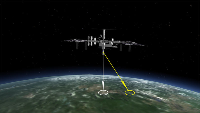
Nadir (white arrow)
Center Point (yellow arrow)
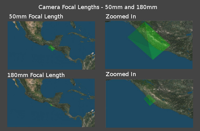
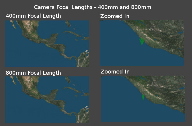
What is the focal length and what does it have to do with the image footprint on the Earth?
The focal length of the camera is based on the camera lens that the crew member used to take the image. The focal length is measured in millimeters. The smaller the focal length (example: 28mm), the wider the field of view in the image. The larger the focal length (example: 800mm), the smaller the field of view in the image. The longer the lens focal length, the more magnification, greater detail, and smaller footprint.

As shown above, the focal length used on the camera plays a rather large role when determining the image footprint on the ground.
What is the sun azimuth?
The sun azimuth is the clockwise angle in degrees from north to the sun. Therefore, if the sun azimuth angle is 90°, this indicates that the sun is to the east. Likewise, 180° is south and 270° is west. This angle is calculated from the nadir point of the International Space Station, not at the center point of the image.
Can you explain the cloud cover percentage choices?
The cloud cover percentage chart below gives a visual representation of each percentage group. The table shows the lowest end of the percentage group to the highest end.
| Types | 0-10% | 11-25% | 26-50% | 51-75% | 76-100% |
|---|---|---|---|---|---|
| Low End |
 |
 |
 |
 |
 |
| High End |
 |
 |
 |
 |
 |
What does it mean when an astronaut photograph is "cataloged"?
When an image is downlinked from the International Space Station, the only information that we are given is that from the camera. We have information about the date and time the image was taken, camera lens that was used, and other camera metadata. We find the nadir position of the ISS from the date and time from the camera. This is how the "Uncataloged" imagery database is structured. Once the ESRS team has the ISS nadir coordinates (see nadir description above), we will manually find the latitude and longitude of the center point of the image and add feature names in the description. This type of image is called "cataloged", and is how the user may search for feature names in our database.
What is the sun elevation angle and how is it calculated?
The sun elevation angle is the angle in degrees between the horizon and the sun, and is measured at the International Space Station's nadir point. These are numerical values, and can range from -90° to 90°. The higher, positive angles indicate that the image will be in daytime light and the negative, lower numbers indicate that the resulting images will be in nighttime. As the number gets more negative and lower, there will be less sunlight in the image. For example: a higher negative number like -5° will be in darkness, but will be immediately following sunset, which is at 0° sun elevation angle. Therefore, that image will still have residual sunlight from the setting sun. The lower the negative number, the less amount of sunlight in the image.
The same holds true for positive sun elevation angles. If the angle is a positive number, like 5°, the light levels will be very low. For reference, we will typically ask the crew for daytime targets with a sun elevation angle over 25°.
What does "ISS paralleling the terminator" mean?
While the ISS is paralleling the terminator, the spacecraft is in constant sunlight and does not see a sunset until the high beta period is over. This has several consequences for the spacecraft itself, but in terms of Earth Science and viewing the Earth from space during this period, it can be challenging. Since the International Space Station is orbiting along the line separating daytime and nighttime on the Earth while orbiting in constant sunlight, the Earth is too light for nighttime targets, but too dark for daytime targets. Therefore, during this time, it is challenging to take pictures of the Earth below.
What are the different choices of cameras?
Throughout the history of Earth Observations from space, there have been several different types of cameras that astronauts have used to take photographs of the Earth. Below is a table of all camera options to search through this database.
| Database camera field value | Manufacturer and/or camera model | Film Width | Original image size |
|---|---|---|---|
| HB | Hasselblad | 70mm | 55mm x 55mm |
| LH | Linhof | 127mm | 105mm x 120mm |
| MA | Maurer | 70mm | 55mm x 55mm |
| MS | Maurer | 70mm | 55mm x 55mm |
| AA | Ansco Autoset | 35mm | 36mm x 24mm |
| NK | Nikon | 35mm | 36mm x 24mm |
| RX | Rolleiflex | 70mm | 55mm x 55mm |
| SA | Skylab S190A | 70mm | 57mm x 57mm |
| SB | Skylab S190B | 127mm | 115mm x 115mm |
| DV | Sony HDW-700 High-Definition Television Camera | 1920px x 1035px | |
| E1 | Black & White experimental Electronic Still Camera | 1024px x 1024px | |
| E2 | Kodak DCS460 Electronic Still Camera | 27.6mm w/3060px x 18.5mm w/2036px, RGBG array | |
| E3 | Kodak DCS660 Electronic Still Camera | 27.6mm w/3060px x 18.5mm w/2036px, RGBG array | |
| E4 | Kodak DCS760 Electronic Still Camera | 27.6mm w/3060px x 18.5mm w/2036px, RGBG array | |
| N1 | Nikon D1 | 23.6mm w/2000px x 15.5mm w/1312px, RGBG imager color filter | |
| N2 | Nikon D2Xs | 23.7mm w/4288px x 15.7mm w/2848px, RGBG imager color filter | |
| N3 | Nikon D3 | 36.0mm w/4256px x 23.9mm w/2832px | |
| N4 | Nikon D3X | 35.9mm w/6048px) x 24.0mm w/4032px | |
| N5 | Nikon D3S | 36.0mm w/4256px x 23.9mm w/2832px | |
| N6 | Nikon D4 | 36.0mm w/4928px x 23.9mm w/3280px | |
| N7 | Nikon D800E | 35.9mm w/7360px x 24.0mm w/4912px | |
| N8 | Nikon D5 | 35.9mm w/5568px x 23.9mm w/3712px | |
| N9 | Nikon D850 | 35.9mm w/8256px x 23.9mm w/5504px | |
| NA | Nikon D6 Electronic Still Camera | 35.9mm w/5568px x 23.9mm w/3712px | |
| NB | Nikon Z9 Electronic Still Camera | 35.9mm w/8256px x 23.9mm w/5504px | |
| C1 | Canon Digital IXUS 700 | 3072px x 2304px largest option | |
| G1 | GoPro Hero 3 Black Edition | ||
| R1 | Red Epic Dragon | 30.7 mm x 15.8 mm (Diagonal: 34.5 mm)/6144 x 3160 effective pixels/19.4 megapixel |
What are the different choices of camera film and formats?
Throughout the history of Earth Observations from space, there have been several different types of cameras that astronauts have used to take photographs of the Earth. Preceding the digital era of photography, cameras on board the ISS used camera film for all photography. Below is a table of all film types to search through this database.
| Film Type | Classification | Description |
|---|---|---|
| 1035I | Digital media | Sony HDW-700 Digital HDTV camcorder, 15x zoom lens, 1920 x 1035 interlaced |
| 2000E | Digital media | 2000 x 1312 pixel CCD, RGBG imager color filter |
| 2041 | Color negative | Kodak Pro PMZ 1000, color negative, process C-41, 35mm or 120mm |
| 2106 | Color negative | Kodak Vericolor III, 70mm negative unperforated, process C-41 |
| 2402 | Black and white | Kodak Plus-X Aerographic 70mm black and white |
| 2415 | Black and white | Kodak Technical Pan Film 2415 Estar AH Base, B&W positive, ASA 100 |
| 2443 | Color infrared | Kodak Aerochrome 2443, color IR, thin base, EA-5 process thru June 1999, E-6 process afterward |
| 2447 | Color positive | Kodak Aerochrome II Duplicating Film, 70mm, process EA-5 |
| 2448 | Color positive | Fine Grain Aerochrome II color-reversal camera film, 70mm, process EA-5 |
| 3060E | Digital media | 3060 x 2036 pixel CCD, RGBG array |
| 3072E | Digital media | 3072 x 2304 pixels largest option, 1/1.8" CCD, ~7.1M pixels, Primary Color filter type |
| 3101 | Color negative | Kodak, natural color negative, Ektar 100-3101, ASA 125, standard base |
| 4256E | Digital media | 4256 x 2832 pixel CMOS sensor, 36.0mm x 23.9mm, total pixels: 12.87 million, Nikon FX format |
| 4288E | Digital media | 4288 x 2848 pixel CMOS sensor, RGBG imager color filter |
| 4928E | Digital media | 4928 x 3280 pixel CMOS sensor, 36.0mm x 23.9mm, total pixels: 16.6 million, Nikon FX format |
| 5012 | Color positive | Kodak Ektachrome 100, Professional, daylight balance |
| 5017 | Color positive | Kodak, natural color positive, Ektachrome, X Professional, ASA 64, standard base |
| 5025 | Color positive | Kodak Ektachrome X Professional ASA 64 |
| 5026 | Color negative | Kodak, natural color negative, Vericolor III 5026, ASA 160, standard base |
| 5028 | Color positive | Kodak, color positive,Vericolor 400 Proof (VPH),ASA 400, standard base |
| 5030 | Color negative | Kodak, natural color negative, Ektapress 5030, ASA 1600,standard base |
| 5036 | Color positive | Kodak, natural color positive, Ektachrome 5036,200 Professional, ASA 200, stand |
| 5046 | Color positive | Kodak, natural color positive, Lumiere 100/5046, ASA 100, standard base |
| 5048 | Color positive | Kodak, natural color positive, Lumiere 100x/5048, ASA 100x, standard base |
| 5069 | Color positive | Kodak Elite 100S, E6 Reversal, Replaces Lumiere, Warmer in tone vs. Lumiere |
| 5074 | Color positive | Kodak Ektachrome 400, Daylight |
| 5080 | Color negative | Kodak Pro 400, color negative, ASA 400, 35mm |
| 5095 | Color negative | Kodak, color negative, Kodacolor VRG/100, ASA 100, standard base |
| 5096 | Color negative | Kodak, color negative, Gold Super 200, ASA 200, standard base |
| 5245 | Color positive | Kodak EXR 500 |
| 5250 | Color negative | Eastman Color Negative, 35mm |
| 5327 | Color positive | Kodak, natural color positive, Ektar 25 Professional, ASA 25, standard base |
| 5568E | Digital media | 5568 x 3712 pixel CMOS sensor, 35.9 x 23.9 mm, total pixels: 21.33 million, Nikon FX format |
| 5755 | Color negative | Portra 160NC, color negative, 35mm, ASA 160 |
| 5775 | Color negative | Portra 400NC, color negative, 35mm, ASA 400 |
| 5776 | Color positive | Portra 400VC, color negative, 35mm, ASA 400 |
| 6017 | Color positive | Kodak Ektachrome 64, 220 Roll Format |
| 6048E | Digital media | 6048 x 4032 pixel CMOS sensor, 35.9mm x 24.0mm, total pixels: 25.72 million, Nikon FX format |
| 6118 | Color positive | Kodak Ektachrome 64T, color positive, Professional Film, ASA 64 |
| 6144E | Digital media | 19.4 megapixel CMOS, 6144 x 3160 effective pixels, 30.7 mm x 15.8 mm (diagonal: 34.5 mm) |
| 7360E | Digital media | 7360 x 4912 pixel CMOS sensor, 35.9mm x 24.0mm, total pixels: 36.8 million, Nikon FX format |
| 8256E | Digital media | 8256 x 5504 pixel CMOS sensor, 35.9mm x 23.9mm, total pixels: 46.89 million, Nikon FX format |
| 8256E2 | Digital media | 8256 x 5504 pixel Stacked CMOS sensor, 35.9mm x 23.9mm, total pixels: 52.37 million, Nikon FX format |
| 8443 | Color infrared | Kodak Aerochrome IR, process: EA-4, replaced by 2443 |
| ANSCO | Color positive | Anscochrome T-100 Superior, ASA 100/64, Color positive |
| E2424 | Black and white | Kodak B&W infrared, no filter |
| E2424C | Black and white | Kodak B&W infrared, 0.7-0.8 micron filter band-pass |
| E2424D | Black and white | Kodak B&W infrared, 0.8-0.9 micron filter band-pass |
| E2443 | Color infrared | Kodak color infrared |
| E3414 | Black and white | Kodak Cadmium-enriched Hi-definition B&W Aerial film, "minus blue" Wratten filter |
| E3443 | Color infrared | Kodak infrared color, "minus blue" Wratten filter |
| EKTAR | Color negative | Kodak Ektar 25 color negative Professional Film, ASA 25 |
| FJ400 | Color negative | Fuji natural color negative, FUJI NHG, ASA 400, standard base |
| FJ800 | Color negative | Fuji color negative, 35mm, ASA 800 |
| QX | Color infrared | Kodak color infrared |
| QX807 | Color positive | SO368 film (fine-grain Ektachrome) with yellow dye layer equivalent to Wratten 2A |
| QX824 | Color positive | Kodak Ektachrome 64 |
| QX868 | Color positive | Kodak, natural color positive, Ektachrome QX868(5017 emulsion), ASA 64, thin base |
| RS200 | Color positive | AGFA, natural color positive, Agfachrome 200RS Professional, ASA 200, standard |
| RS50 | Color positive | AGFA, natural color positive, Agfachrome Plus Professional, ASA 50, standard |
| RUSSI | Unspecified | Russian film of various types |
| SG800 | Color negative | FujicolorSG800, negative, 35mm, ASA 800 |
| SN-10 | Color infrared | Russian Color Infrared,2 dye layer, est. ASA 64,chlorophyl response is green |
| SO022 | Black and white | Kodak B&W infrared, no filter |
| SO022A | Black and white | Kodak Panatomic-X B&W, 0.5-0.6 micron filter band-pass |
| SO022B | Black and white | Kodak Panatomic-X B&W, 0.6-0.7 micron filter band-pass |
| SO117 | Color positive | Kodak, natural color positive, Ektachrome SO117, ASA 400, standard base |
| SO121 | Color positive | Kodak Ektachrome 64 |
| SO131 | Color infrared | Kodak High Definition Aerochrome and Estar thin base, infrared color, "minus blue" Wratten filter |
| SO180 | Color infrared | Kodak Ektachrome infrared |
| SO217 | Color positive | Kodak Ektachrome with haze filter |
| SO242 | Color positive | Kodak hi resolution color |
| SO356 | Color positive | Unknown SkyLab |
| SO368 | Color positive | Kodak Ektachrome MS, equivalent to 2448 Kodak Aerochrome, ASA64, thin base, fine grain |
| SO489 | Color positive | Kodak Ektachrome, high speed, ASA 400 |
| UNKN | Unspecified | unknown |
| VELVI | Color positive | Fuji, natural color positive, Velvia 50, CS 135-36, ASA 32, standard base |
North is not at the top of the photo. Is there some mistake?
Astronauts take these photographs out of the windows of spacecraft, and the camera can be in any direction relative to the Earth. Because of this, North can be in any direction relative to the top of the photo.
Why can you not see stars or galaxies in the photographs that show the curvature of the Earth and part of the black background of space?
The reason you can't see stars in high oblique photos is that the shutter speed is too fast. Fast shutter speeds are used to eliminate blur from the motion of the spacecraft. One exception to this rule is when astronauts use camera settings specifically to photograph features such as the Aurora Borealis and Aurora Australis. The crew must use slower shutter speeds in order to capture the light of the aurora. In these cases stars also show up in the photograph. The photos are also slightly blurry because very long exposures are needed to capture these dim nighttime features.
Is it true that the Great Wall of China is the only human-made object that can be seen from space?
The Great Wall is not visible to the naked eye from orbit, as recently demonstrated by China's first astronaut (Yang Liwei) who admitted that he was unable to see it. It is not visible from the Moon. The greatest detail we have observed from astronaut photos using long lens on cameras is 6 m pixels meaning that each dot on the image is equal to 6 m on the ground. In these most detailed photos, you can see neighborhood streets (unless they are heavily tree-lined) but not individual houses. The Wall does appear to be visible in some recent high-resolution astronaut photographs, which you can search for using our database tools.
Where can I find a photograph of the whole Earth as seen from space?
We like the image of the Big Blue Marble" taken from Apollo-17. A private company called Arc Science Simulations has also made satellite composites that have been used in posters and museum displays. These aren't real photographs, but are combined from many satellite images to show what the Earth would look like if there were, for example, no clouds. The NASA Earth Observations site also offers global mosaics of MODIS data for download. Global mosaics are available for various times of year.
Do the photos show the view exactly as it appears to the naked eye out of the spacecraft?
It depends on the lens used. Lower magnification lenses (< 90 mm) have a field of view that is more similar to what an astronaut can see when just looking out the window. Longer magnification lenses are more similar to what the astronaut sees when using binoculars to magnify and narrow the field of view.
What kind of film is used?
In the past, photographs taken used primarily color positive film, however, black and white and color-infrared film were also used. Digital cameras are now exclusively used on the International Space Station. This format offers the advantage that the images be transmitted back to the ground and are already digital and ready for distribution on the web. Additional details about cameras and film are available in the database record for each image.
How do I know if an image on the website is the best possible quality?
Digital images posted to our website come from a variety of sources--some have been scanned from film and some were acquired digitally. The information in the "CAMERA" field tells you what kind of camera, and the image in the "FILM" field tells you what kind of film or what kind of CCD for a digital camera. Images scanned from film will vary in quality because they may have been scanned in the past using video technology, scanned by hand, or scanned in a batch mode where setting were not optimal for a particular photograph. Almost all images scanned from film and posted on our site will require some color correction before use in publications. Batch color correction has been performed on some, but not all, digital camera images. Most of the files posted to the web are saved in JPEG format, which is lossy, which also can degrade the quality of the image, but makes it much quicker to download. Scientists needing high levels of quality control for using a photograph as digital data for remote sensing can also request downlink of raw camera files, when available, from image database record page. Publishers and commercial interests needing higher quality images should contact the JSC Communications team.
In order to obtain a raw camera file: visit the Display Record page for the photo. In the tabbed section below the image, click on "ALL DOWNLOAD OPTIONS", where there is an option to request the raw camera file. It will take several minutes to retrieve the image from the database. There are select cases where there is no raw camera file available for the image.
What kind of color correction is used on images taken with a digital camera?
The images in our database represent an agglomeration of sources--some of which have included color correction and some have not. For example, some space station expeditions (ISS-4 and ISS-5) photographed a color card on orbit and this was used to develop a color correction algorithm that could be applied to the images on the ground. All of the above processes are somewhat outside the control of the Earth Sciences and Image Analysis Laboratory and apply equally to photographs of Earth and photographs of other subjects. We do hand color correction only for a very few images that are posted with captions to collections such as Earth Observatory or Earth from Space. To get publication-quality results you will probably need to adjust the color balance and contrast for most images downloaded from our site. For scientists that are interested in the spectral content of the image, we recommend downloading the raw camera file. If no raw camera file is available, contact us for further assistance.
How does the resolution compare with data from robotic satellites like Landsat or SPOT?
If the image is converted to digital form, the pixel size depends on the lens used, the look angle, and the resolution at which the image is scanned. One can look at the absolute best possible resolution (looking perfectly nadir of the orbit) based on the geometry of the altitude, film size and focal length).
Table: Maximum possible digital resolution (minimum pixel width in m) for hand-held photographs scanned at 2400 ppi.
| Camera | Lens | Spacecraft Altitude | ||
|---|---|---|---|---|
| Minimum 222 km (120 n. mi.) |
Median 326 km (176 n. mi.) |
Maximum 611 km (330 n. mi) |
||
Linhof |
90 mm | 26.1 | 38.3 | 71.8 |
| 250 mm | 9.4 |
13.8 | 25.9 | |
| Hasselblad | 100 mm | 23.5 | 34.5 | 64.7 |
| 250 mm | 9.4 | 13.8 | 25.9 | |
| Nikon | 300 mm | 7.8 | 11.5 | 21.6 |
| 400 mm | 5.9 | 8.62 | 16.2 | |
Because most views are not perfectly nadir, a more conservative rule of thumb for an average 176 n. mi. (296 km) mission is that the 100-mm lens offers spatial resolution similar to that of the Landsat Multispectral Scanner (approximately 80 meters) and the 250-mm lens has resolution similar to that of the Landsat Thematic Mapper (approximately 30 meters).
How does pixel size or instantaneous field of view relate to the size of objects that can actually be distinguished in a space photograph?
Even though people often say that TM "resolution" is 30 m, that is actually technically incorrect. For Landsat TM, pixel size or instantaneous field of view (IFOV) is what is actually 30 m x 30 m. This number does not mean that objects of 30 m in width can be identified in an image. The ability of the system to image objects of various widths depends on a number of factors i including the contrast between the objects. A more inclusive and realistic (but also subjective) measure of resolution used primarily in aerial photography is ground resolved distance (GRD).
Instead of specifying a resolution for an entire system, you can also think about resolution from an image-specific point of view. In general every image has a ground resolved distance (GRD) that depends on spatial resolution, contrast and texture as well as on the characteristics of the system that was used to capture the image. As an example, image a winter scene and a summer scene of a northern deciduous forest with clearcut areas. The winter scene will have higher contrast (snow vs. trees) than the summer scene (snow vs. green meadows). Thus, for a study trying to identify the size of clear-cuts in the area, a TM image in winter will have better GRD than one taken in the summer, and smaller clear-cuts would be able to be distinguished in the winter scene.
As far as ground resolved distance is concerned, our best case so far (with a 1000mm lens) is resolving 2 to 3 meter objects on the ground. These have included building shadows, roads, and boats in harbors. Most photographs have much lower resolution.
Since astronauts are traveling so fast in orbit, why don't the photographs look smeared?
If you do the calculation for the amount of ground smear expected based on the shutter speed of the camera and the velocity of the International Space Station relative to the ground, you would expect that the ground resolved distance could be no better than about 30m. Because we have much better resolution (i.e. boats in harbors, narrow roads), we know that consciously or unconsciously, astronauts track the Earth when they take a photo, so the resolution is actually better than you would calculate.
How can I use astronaut photographs in scientific research?
The photographs have a great deal of information value "as-is" because they provide a broad geographic perspective on climate, geology, ecology, oceanography and other disciplines. In addition these photographs provide the longest possible time series of information documenting changes in the Earth.
What does the "Features from Machine Learning" checkbox do?
Searching the photo database with this box checked allows you to search for images that were not necessarily cataloged by humans. A deep neural network is used to recognize certain features of interest. If a search is performed that includes one or more of these features as keywords and the “Features from Machine Learning” box is checked, those images will be included in the results.
Because machine-cataloged images were not inspected by humans, there may be some errors. Machine-cataloged images have not been fully cataloged, so some fields are missing. Unchecking this box will allow you to only see images where features were identified by humans.
The following features are searchable in this way:
LIGHTNING
MOON
PAN- (where the limb of the Earth is visible)
What does the "Include Panorama Imagery" checkbox do?
Searching the photo database with this box checked will include images that have been labeled with “PAN-“, so long as these images match the other filters. “PAN-“, indicates a panorama shot, which usually contains the limb of the Earth.
What are cloud masks that are available for some imagery?
A cloud mask is an image with the same pixel resolution as the largest size image available for a particular frame, which indicates where clouds are in that image. These masks are created using a type of convolutional neural network trained to identify clouds, and segments the image by giving each pixel a score from 0 to 255.
The heat map image is a uint8 grayscale image where white pixels were identified as containing cloud, and dark pixels were identified as containing no cloud. The binary image is a black and white copy of the heat map, where a threshold of 25 is used to filter pixels into two categories. Pixels with a score of 0-25 are assumed to not contain cloud and made black, whereas pixels with a score of 26-255 are assumed to contain cloud and made white.
How are cloud masks generated?
Cloud masks are created using a convolutional neural network that was trained on 262 high-resolution images. Each training image was manually segmented into cloud and non-cloud pixels. Both original photographs and the manually-labeled masks were cut into smaller 672x448 pixel images and shuffled.
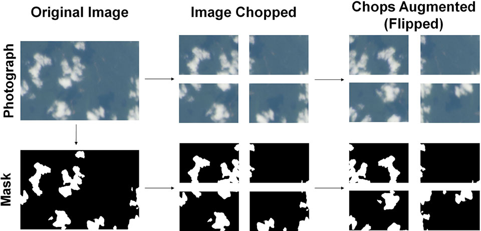
Once the training data was assembled, it was fed as an input into the convolutional network in batches, as shown in the image below. The neural network was comprised of an encoder and a decoder working in conjunction. The encoder consisted of 4 convolutional layers with increasing numbers of filters (32, 64, 128, and 256), each followed by a Rectified Linear Unit (ReLU) activation and a max pooling layer. The decoder contained 4 convolutional layers with decreasing numbers of filters (256, 128, 64, 32), each followed by a ReLU activation and an upsampling layer. The final upsampling layer was followed by a sigmoid activation for output, resulting in an output between 0 and 255.

The 672x448 pixel outputs were then reassembled into the full-resolution cloud mask, and the output image produced by the neural network was then post-processed with a Conditional Random Field (CRF). This results in the final outputs having more defined edges and ensures that pixels with the same color in the original photograph that are near each other get the same classification.
What do all of the fields in the Display Record page mean?
| Field Name | Possible Values | Description | ||||
|---|---|---|---|---|---|---|
| mission | See the selection list on the query forms that list mission options for the possible values. | This is the name of the mission using an approved standard for Earth Observations purposes. | ||||
| filmms | See the selection list on the main form for the possible values. | This is the name of the mission as it is printed on the film. | ||||
| roll | NNNX where NNN is the right-justified numeric portion of the roll, no leading zeros, and X is an alphabetic extension if available, otherwise it is blank. At least one mission has odd roll IDs which start a letter. For these missions simply left justify. |
The roll identifies the roll of film the photograph is on.
For digitally-acquired images in the NASA collection, it is E. For digitally-acquired images
from other sources, it takes on other values:
|
||||
| frame | NNNNNNNXX where NNNNNNN is the right-justified numeric portion of the frame, no leading zeros,
and XX is the right-justified alphabet extension on the frame ID e.g. " 1 A"& "1234567AB" |
The frame identifies the photograph in the roll. For digitally-acquired images, it is uniquely assigned either in downlink sequence or based on the time the image was acquired. | ||||
| geon | See the selection list on the main form for the possible values. | This usually identifies the country. Sometimes, when a country was unavailable, it identifies the predominant feature, such as "CLOUDS" or "OCEAN". | ||||
| feat | 75 characters of text. | This identifies features found in the photograph such as smoke or city names. We recommend you use the most specific terms possible, and avoid generic terms such as RIVER or R that may be abbreviated and will occur in thousands of entries. | ||||
| lat | Signed floating point number. Valid values range in [-90.0,90.0]although the photographs will be virtually all between -60 and 60. |
This is the latitude of the center point of the photograph. Negative values indicate South of the equator. | ||||
| long | Signed floating point number. Valid values range in [-180.0,180.0]. |
This is the longitude of the center point of the photograph. Negative values indicate West of the prime meridian. | ||||
| expo | "N" (normal), "U" (under-exposed), "O" (over-exposed), "F" (out of focus). | Indicates the film exposure quality. Not tracked after STS096 (June 1999). | ||||
| tilt | "NV" (near vertical), "LO" (low oblique), "HO" (high oblique), look angle. | Indicates how the camera was tilted with respect to the Earth. "NV" indicates that the camera was looking nearly straight down at the Earth. "LO" indicates that some angle is noticeable but not enough to show the horizon. "HO" indicates that the tilt is great enough that the horizon is visible. When enough information is available to calculate a look angle, instead of using the tilt values of "NV" and "LO", the look angle from nadir to the center of the photo as measured from the camera/spacecraft location is used. | ||||
| cldp | Integer [0, 100]. | Specifies what percentage of the photograph is clouds. | ||||
| steo | "Y" or "N". | "Y" means Yes there is an adjacent photograph of the same area. "N" means No there is not. Not tracked after STS096 (June 1999) | ||||
| fclt | Positive integer. Units are millimeters. | Indicates the focal length of the camera lens used. Note that this is not logged by the crew. So for film cameras the most likely lens size is determined by analyzing the photograph. Electronic cameras record the lens size and so that is what is used for them. | ||||
| caption | "Y" or "N". | "Y" means Yes there is a caption in the captions table for this photograph. "N" means no there is not. | ||||
| image | Positive integer. | This is a count of how many images there are for this photograph in the images table. | ||||
| dir | "N ", "NE", "E ", "SE", "S ", "SW", "W ", or "NW". |
Indicates the direction from the spacecraft nadir (suborbital) point to the center point of the photograph.
"N" stands for North, "S" for South, "E" for East, and "W" for West.
Since the camera can be rotated in any direction without affecting the direction from the spacecraft nadir point to the center of the photograph, and since photographs can be viewed at any rotation, this field does not suggest that the top of the photograph is in the direction specified. This field is most useful for oblique photographs where it is possible to see the direction from the camera, visible as the edge of the photograph that appears to be the closest, to the center of the photograph, and thus determine the compass direction associated with that vector. |
||||
| onc, jnc | Text fields. | Specifies the ONC and JNC map identifications for navigational charts produced by the Defense Mapping Agency. These fields were no longer recorded beginning with STS093 (July 1999). | ||||
| nlat | Signed floating point number. Valid values range in [-90.0,90.0]although the photographs will be virtually all between -60 and 60. |
This is the latitude of the nadir point (suborbital point) of the space craft at the time the photograph was taken. Negative values indicate South of the equator. | ||||
| nlon | Signed floating point number. Valid values range in [-180.0,180.0]. |
This is the longitude of the nadir point (suborbital point) of the space craft at the time the photograph was taken. Negative values indicate West of the prime meridian. | ||||
| pdate | 8 character text field consisting of numeric digits. | The GMT date the photograph was taken in the form "YYYYMMDD" where YYYY is the year, MM is the month, and DD is the day of the month. | ||||
| ptime | 6 character text field consisting of numeric digits. | The GMT time the photograph was taken in the form "HHMMSS" where HH is the hour, MM is the minute, and SS is the second. | ||||
| orb | Positive integer. | This is the orbit number the space craft was on when the photograph was taken. Note that this is only meaningful on short duration flights that orbited the Earth. | ||||
| azi | Positive integer in the range [0, 360). |
Specifies the angle in degrees from north to the location of the sun measured clockwise at the nadir location. | ||||
| elev | Integer in the range [-90, 90]. |
Specifies the sun elevation angle. This is the angle from the horizon to the sun measured in degrees at nadir. Negative values indicate that the sun is below the horizon. | ||||
| alt | Positive integer. | Specifies the altitude above the Earth's surface of the space craft in nautical miles. | ||||
| camera | This is a two character code. See the metatdata link at the left for possible values. | This is the make of camera. | ||||
| film | This is an eight character code. See the metatdata link at the left for possible values. | For film cameras, this is the type of film. For digital cameras, this gives the imaging format. |
| Field Name | Possible Values | Description | ||||
|---|---|---|---|---|---|---|
| mission | See the selection list on the main form for the possible values. | This is the name of the mission using an approved standard for Earth Observations purposes. | ||||
| roll | NNNX where NNN is the right-justified numeric portion of the roll, no leading zeros, and X is an alphabetic extension if available, otherwise it is blank. At least one mission has odd roll IDs which start a letter. For these missions simply left justify. | The roll identifies the roll of film the photograph is on.
For digitally-acquired images in the NASA collection, it is E. For digitally-acquired images
from other sources, it takes on other values:
|
||||
| frame | NNNNNNNXX where NNNNNNN is the right-justified numeric portion of the frame, no leading zeros,
and XX is the right-justified alphabet extension on the frame ID e.g. " 1 A"& "1234567AB" |
The frame identifies the photograph in the roll. For digitally-acquired images, it is uniquely assigned either in downlink sequence or based on the time the image was acquired. | ||||
| caption | Text. | This contains all the captions along with their HTML in a single 32765 character text field. |
| Field Name | Possible Values | Description | ||||
|---|---|---|---|---|---|---|
| mission | See the selection list on the main form for the possible values. | This is the name of the mission using an approved standard for Earth Observations purposes. | ||||
| roll | NNNX where NNN is the right-justified numeric portion of the roll, no leading zeros, and X is an alphabetic extension if available, otherwise it is blank. At least one mission has odd roll IDs which start a letter. For these missions simply left justify. | The roll identifies the roll of film the photograph is on.
For digitally-acquired images in the NASA collection, it is E. For digitally-acquired images
from other sources, it takes on other values:
|
||||
| frame | NNNNNNNXX where NNNNNNN is the right-justified numeric portion of the frame, no leading zeros,
and XX is the right-justified alphabet extension on the frame ID e.g. " 1 A"& "1234567AB" |
The frame identifies the photograph in the roll. For digitally-acquired images, it is uniquely assigned either in downlink sequence or based on the time the image was acquired. | ||||
| version | 3 character text field. Valid values are quoted positive integers other than 1 e.g. "2 " and "123". | This identifies how many different images of a given type (see the type field) there are for the photograph. If there is only one version, then this field is NULL. | ||||
| filename | Text field of the form mission-roll-frame_version.type where _version only exists if the version is not NULL. There are no spaces in this field. | This is the name of the image file. | ||||
| width, height | Positive integers. | Specifies the width and height of the image in pixels. | ||||
| annotated | "Y" or "N". | "Y" means Yes the image is annotated. "N" means No it is not. | ||||
| cropped | "Y" or "N". | "Y" means Yes the image is cropped. "N" means No it is not. | ||||
| directory | "SCANNED" or "lowres\mission". | Specifies the directory where the image file is located. | ||||
| purpose | Text. | This is a brief phrase identifying the purpose for why this image file was created. | ||||
| comments | Text. | Any comments deemed appropriate. | ||||
| filesize | positive integer. | The size of the image file in bytes. |
Camera Metadata: STEO
STEO stands for stereo. "Y" means Yes there is an adjacent photograph of the same area. "N" means No there is not. Generally, both members of a pair must have the same exposure (EXPO) value. Usually the STEO field is "Y" only in cases where both have normal exposure. Some variable exposures might work for stereo viewing. To find stereo views, look for values of "Y" in the STEO field in adjacent frames of the same mission and roll. This field is not being cataloged beginning with STS093 (July 1999).
Camera Metadata: EXPO
EXPO stands for exposure and indicates the film exposure quality. Possible values are "N" (normal), "U" (under-exposed), "O" (over-exposed), "F" (out of focus). The qualitative nature of this field leads to subjectiveness in the data. There is no distinction between extreme or slightly underexposed/overexposed. This field is not being cataloged beginning with STS093 (July 1999).
Camera Metadata: ROLL
NASA has used the single letter E to identify images that were originally captured in digital form including electronic still camera (ESC) and High Definition Television (HDTV) images. The NASA number is of the form sXXeYYYY where XX is the 2-digit Shuttle Mission, and YYYY is an arbitrarily assigned sequential number. This database organizes photograph identifiers (IDs) into three components, a mission component, a roll component and a frame component. In order to accommodate ESC and HDTV imagery, since it has no film "roll", it was originally decided to use "ESC" and "HDTV" as the roll. This provided more clarity to the casual user and helped avoid possible future conflicts with other non-ESC/HDTV roll IDs being assigned E (some roll IDs in the past have been single letters).
EarthKAM (also known as KidSat), a NASA-funded educational project where middle school students control a camera mounted on the Space Shuttle or International Space Station, has cross-indexed its images with our database so that searches of our database will also find relevant EarthKAM images. During its time on the Space Shuttle, the EarthKAM-assigned number is of the form STS0XX-ESC -YYYYYYYY, where XX is the 2-digit Shuttle mission number, and YYYYYYYY represents the MET (mission elapsed time) of the image. These images were also numbered separately by NASA, and a cross-reference table is available. From the International Space Station, EarthKAM numbers will be of the form
ISSxxx.ESCy.dddhhmmss
xxx is the station increment - the crew number, so flights in October and December 2001 will have the mission designation ISS003
y is the EarthKAM mission designation - for the first EarthKAM data taking opportunity within a station increment y will be 1, for the second 2 and so on. So for the flight in October 2001 the first two fields in the Image ID will be ISS003.ESC1 and in December they will be ISS003.ESC2
dddhhmmss is the time (GMT) the image was taken - ddd is the julian day of year (001-365), hh is the hour (00-23), mm is the minute (00-59) and ss is the second (00-59). GMT is Greenwich Mean Time, (aka UTC) and reflects the mean solar time along the Earth's prime meridian.
so for an image capture at 11:30 PM GMT on October 1 on our first official EarthKAM "flight" on ISS the Image ID will be...
ISS003.ESC1.274233000
In an effort to distinguish NASA's ESC from EarthKAM's ESC, it was decided that this database would adopt NASA's convention of using only the single letter E as the roll component of the photograph ID for non-EarthKAM images taken with the ESC, and would follow EarthKAM's numbering conventions for the images they acquired using the ESC. So in April of 2002, all NASA ESC image IDs were changed over to using the single letter E for the roll component. Using HDTV as the roll identifier for HDTV images does not conflict with EarthKam's convention, so this database retains the HDTV roll identifier.
The search tools have been set to consider ESC, E and HDTV as roll synonyms so that images will be returned for searches using either convention.
Digital still camera imagery from the International Space Station follows a similar format to Shuttle imagery, and is numbered as ISSXXX-E-YYYYY, where XXX is the Expedition number, such ISS007 for Expedition 7; E indicates a digital still camera frame; and YYYYY is the frame number, such as 10000 – leading to an image ID of ISS007-E-10000.
Camera Metadata: Country or Geographic Name
The GEON (geographic name) field usually represents the country, or for some large countries, country and state or province. However, when there are large discontinuous regions within political boundaries, we use other geographical categories. For Example, Easter Island (Isla de Pascua) is part of the territory of Chile, however, because it is far from the boundaries of the mainland of Chile, we have created a separate GEON for Easter Island. Our field lists "Geographic Region, Country or U.S. State" and discontinuous regions are not lumped with their political ownership. Also note that although we are aware of the many political changes going on each day, images are cataloged at a point in time. Current political boundaries and names may not be reflected in all the database records for some locations.
Camera Metadata: Features
The features field is where catalogers put geographical or topical words that describe the contents of an image. Features found in the photograph other than geographic place names might include “smoke,” “fire,” “ dust,” “clouds,” etc.
Searching Tips for this Field
Since these values vary in type and order, it is suggested that you use CONTAINING as the operator for SQL searches. When using the technical search form, this is done automatically for you. This will allow you to search for substrings and this operator does a case insensitive search. In searching for contents in this field, we recommend you use the most specific terms possible, and avoid generic terms such as RIVER or R., that may be abbreviated and will occur in thousands of entries.
Understanding Values in this Field
List of abbreviations used in the features field. Please note that when space permits, we use periods (.) at the end of each abbreviation and commas to separate terms. However, if space is limited we sacrifice the (.) in order to include the maximum amount of information in the field.
| Feature | Abbreviation |
|---|---|
| AGRICULTURE | AGR. |
| ARCHIPELAGO | ARCH. |
| ARROYO | AR. |
| ATOLL | AT. |
| BASIN | BN. |
| BAY | B. |
| BIGHT | BGT. |
| CANAL | CAN. |
| CANYON | CAN. |
| CAPE | C. |
| CHANNEL | CHAN. |
| CITY | CY. |
| CLOUDS | CL. |
| CREEK | CR. |
| DAM | D. |
| DEFORESTATION | DEFOR. |
| DEPRESSION | DEP. |
| DESERT | DES. |
| DRAINAGE | DRAIN. |
| EAST | E. |
| ESCARPMENT | ESCARP. |
| ESTUARY | EST. |
| FJORD | FJ. |
| FOREST | FOR. |
| GLACIER | GL. |
| GULF | G. |
| HURRICANE | HURRIC. |
| INDUSTRY | INDS. |
| INTERNATIONAL SPACE STATION | ISS |
| ISLAND(S) | I. |
| ISTHMUS | ISTH. |
| LAGOONS | LAG. |
| LAKE(S) | L. |
| MASSIF | M. |
| MOUNTAIN/MOUNT | MT. |
| MOUNTAINS | MTS. |
| NORTH | N. |
| NORTHEAST | N.E./NE. |
| NORTHWEST | N.W./NW. |
| OCEAN | O. |
| PANORAMA | PAN./PAN-* |
| PARK | PRK. |
| PARTIAL FRAME | PART. FRM. |
| PASSAGE | PASS. |
| PEAK | PK. |
| PENINSULA | PEN. |
| PLANE | PLN. |
| PLATEAU | PLAT. |
| PLAYA(S) | P. |
| POINT | PT. |
| PORT | PO. |
| PROVINCE | PROV. |
| RANGE | RA. |
| REFLECTION(S) | REFL. |
| RESERVOIR(S) | RES. |
| RIVER(S) | R. |
| SALAR | S. |
| SEA | S. |
| SEDIMENT | SED. |
| SMOKE | SMK. |
| SOUTH | S. |
| SOUTHEAST | S.E./SE. |
| SOUTHWEST | S.W./SW. |
| SPACE SHUTTLE | SHUT. |
| SAINT | ST. |
| STRAIT | STR. |
| SUNGLINT | SNGLNT. |
| THUNDERSTORM(S) | T/S |
| VALLEY | V. |
| VOLCANO | VOL. |
| WEST | W. |
*The term “PAN” has a very specific meaning used in our database. PAN is used to indicate that the view was panoramic. This generally means that the horizon was also visible in the image. The TILT field for these frames is set to be HIGH OBLIQUE (HO).
Camera Metadata: LAT/LONG
LAT stands for latitude. Valid values range in [-90.0,90.0] although the photographs will be virtually all between -60 and 60. This is the latitude of the center point of the photograph. Negative values indicate South of the equator. LONG stands for longitude. Valid values range in [-180.0,180.0]. This is the longitude of the center point of the photograph. Negative values indicate West of the prime meridian. Determination of center point is done very approximately for the purposes of rapid cataloging: From STS001 through STS078, for example, the accuracy standard for center point was considered +/- 2 degrees. From STS078 through STS096, the standard was +/- 1 degree of latitude and longitude. Beginning with STS093 the data is entered by the cataloger clicking on a map--the accuracy of this click is considered within +/- 1 degree of latitude and longitude. In all cases accuracy will be greater for near vertical photographs than for more oblique photographs, and greater for targets with features that are readily distinguished on the maps. Precision of the center point measurement is 0.5 degrees, in other words, the estimate of center point latitude and longitude is rounded to the nearest 0.5 degree.
Camera Metadata: Tilt

Tilt is the calculated look angle away from a straight nadir (straight down below the spacecraft) view. If the tilt exceeds a certain angle, 55 degrees, then "HO" in the TILT field indicates that the look angle is very oblique and the horizon is probably visible. Although the field is now calculated from the spacecraft location data whenever it is available, it was input by hand for many years. When the cataloger looks at the image, they indicate that the horizon was visible, by entering "PAN-" at the beginning of the feature field. If "PAN-" is at the beginning of the feature field, then the tilt field is constrained to be "HO."
Camera Files
Camera files are the camera-acquired data downlinked from orbit with a digital photograph. If Ku-band is not available, or if there are other technical problems, images have sometimes been compressed and downlinked in other image formats. In these cases, the camera-acquired data on date, time, lens, shutter speed, etc. is lost. This occurred primarily in the early ISS missions and has not occurred for Space Shuttle (STS) missions.
Camera Metadata: DAY
An electronic data-back was added to the camera to automatically record the date and time on the film when the photograph was taken beginning with STS41D (August 1984). Data-backs sometimes malfunction. You can distinguish cases with estimated dates by whether or not the TIME field also has an entry. This field can only be entered from data-back records.
For short-duration missions (less 30 days), if no other date is available, we enter the month and year of the median day of the mission. If there are an even number of days in a mission, and the median straddles a change in month, then the first month and year are used. For short- and long-duration missions, the scientists who worked with the mission on a daily basis help to provide estimated date information when the data-back malfunctions.
Nadir point data (the NLAT, NLON, PDATE, PTIME, ORB, AZI, ALT, ELEV database fields) are calculated using the times recorded by the camera equipment. If post-mission analysis determines that there are errors in the time recorded, then a time adjustment is estimated and nadir data cannot be calculated. If the time is off by less than a minute, the seconds field is blanked out. If the time is off by a minute or more but less than an hour, then the minutes and seconds fields are blanked out. If the time is off by an hour or more then the whole time field (hour, minute and second) is blanked out.
If post-mission analysis determines that there are errors in the date recorded, then the correct date is estimated if possible. If the correct date cannot be estimated, then as much date as can be verified (such as month or year) is entered in the field.
Missions used in the Database
| Program | Database Mission ID | Film Mission ID | GMT Launch/Docking Date | GMT Launch/Undocking Date | Degrees Inclination | Nautical Miles Altitude |
|---|---|---|---|---|---|---|
| Artemis | ART002 | N/A | 04/01/2026 | 04/11/2026 | ||
| International Space Station | ISS074 | N/A | 12/09/2025 | TBD | 51.6 | |
| International Space Station | ISS073 | N/A | 04/19/2025 | 12/09/2025 | 51.6 | |
| International Space Station | ISS072 | N/A | 09/23/2024 | 04/19/2025 | 51.6 | |
| International Space Station | ISS071 | N/A | 04/06/2024 | 09/23/2024 | 51.6 | |
| International Space Station | ISS070 | N/A | 09/27/2023 | 04/06/2024 | 51.6 | |
| International Space Station | ISS069 | N/A | 03/28/2023 | 09/27/2023 | 51.6 | |
| International Space Station | ISS068 | N/A | 09/29/2022 | 03/28/2023 | 51.6 | |
| International Space Station | ISS067 | N/A | 03/30/2022 | 09/29/2022 | 51.6 | |
| International Space Station | ISS066 | N/A | 10/17/2021 | 03/30/2022 | 51.6 | |
| International Space Station | ISS065 | N/A | 04/17/2021 | 10/17/2021 | 51.6 | |
| International Space Station | ISS064 | N/A | 10/21/2020 | 04/17/2021 | 51.6 | |
| International Space Station | ISS063 | N/A | 04/17/2020 | 10/21/2020 | 51.6 | |
| International Space Station | ISS062 | N/A | 02/06/2020 | 04/17/2020 | 51.6 | |
| International Space Station | ISS061 | N/A | 10/03/2019 | 02/06/2020 | 51.6 | |
| International Space Station | ISS060 | N/A | 06/24/2019 | 10/03/2019 | 51.6 | |
| International Space Station | ISS059 | N/A | 03/15/2019 | 06/24/2019 | 51.6 | |
| International Space Station | ISS058 | N/A | 12/20/2018 | 03/15/2019 | 51.6 | |
| International Space Station | ISS057 | N/A | 10/04/2018 | 12/20/2018 | 51.6 | |
| International Space Station | ISS056 | N/A | 06/03/2018 | 10/04/2018 | 51.6 | |
| International Space Station | ISS055 | N/A | 02/27/2018 | 06/03/2018 | 51.6 | |
| International Space Station | ISS054 | N/A | 12/14/2017 | 02/27/2018 | 51.6 | |
| International Space Station | ISS053 | N/A | 09/02/2017 | 12/14/2017 | 51.6 | |
| International Space Station | ISS052 | N/A | 06/02/2017 | 09/02/2017 | 51.6 | |
| International Space Station | ISS051 | N/A | 04/10/2017 | 06/02/2017 | 51.6 | |
| International Space Station | ISS050 | N/A | 10/30/2016 | 04/10/2017 | 51.6 | |
| International Space Station | ISS049 | N/A | 09/06/2016 | 10/30/2016 | 51.6 | |
| International Space Station | ISS048 | N/A | 06/18/2016 | 09/06/2016 | 51.6 | |
| International Space Station | ISS047 | N/A | 03/01/2016 | 06/18/2016 | 51.6 | |
| International Space Station | ISS046 | N/A | 12/11/2015 | 03/01/2016 | 51.6 | |
| International Space Station | ISS045 | N/A | 09/11/2015 | 12/11/2015 | 51.6 | |
| International Space Station | ISS044 | N/A | 06/11/2015 | 09/11/2015 | 51.6 | |
| International Space Station | ISS043 | N/A | 03/10/2015 | 06/11/2015 | 51.6 | |
| International Space Station | ISS042 | N/A | 11/10/2014 | 03/10/2015 | 51.6 | |
| International Space Station | ISS041 | N/A | 09/10/2014 | 11/10/2014 | 51.6 | |
| International Space Station | ISS040 | N/A | 05/13/2014 | 09/10/2014 | 51.6 | |
| International Space Station | ISS039 | N/A | 03/11/2014 | 05/13/2014 | 51.6 | |
| International Space Station | ISS038 | N/A | 11/10/2013 | 03/11/2014 | 51.6 | |
| International Space Station | ISS037 | N/A | 09/10/2013 | 11/10/2013 | 51.6 | |
| International Space Station | ISS036 | N/A | 05/13/2013 | 09/10/2013 | 51.6 | |
| International Space Station | ISS035 | N/A | 03/15/2013 | 05/13/2013 | 51.6 | |
| International Space Station | ISS034 | N/A | 11/19/2012 | 03/15/2013 | 51.6 | |
| International Space Station | ISS033 | N/A | 09/16/2012 | 11/19/2012 | 51.6 | |
| International Space Station | ISS032 | N/A | 07/01/2012 | 09/16/2012 | 51.6 | |
| International Space Station | ISS031 | N/A | 04/27/2012 | 07/01/2012 | 51.6 | |
| International Space Station | ISS030 | N/A | 11/21/2011 | 04/27/2012 | 51.6 | |
| International Space Station | ISS029 | N/A | 09/16/2011 | 11/21/2011 | 51.6 | |
| Space Shuttle | STS135 | 07/08/2011 | 07/21/2011 | |||
| International Space Station | ISS028 | N/A | 05/23/2011 | 09/16/2011 | 51.6 | |
| Space Shuttle | STS134 | 05/16/2011 | 06/01/2011 | |||
| International Space Station | ISS027 | N/A | 03/16/2011 | 05/24/2011 | 51.6 | |
| Space Shuttle | STS133 | 02/04/2011 | 03/09/2011 | |||
| International Space Station | ISS026 | N/A | 11/25/2010 | 03/16/2011 | 51.6 | |
| International Space Station | ISS025 | N/A | 09/24/2010 | 11/25/2010 | 51.6 | |
| International Space Station | ISS024 | N/A | 06/02/2010 | 09/24/2010 | 51.6 | |
| Space Shuttle | STS132 | N/A | 05/14/2010 | 05/26/2010 | 51.6 | 122 |
| Space Shuttle | STS131 | N/A | 04/05/2010 | 04/20/2010 | 51.6 | 122 |
| International Space Station | ISS023 | N/A | 03/18/2010 | 06/02/2010 | 51.6 | |
| Space Shuttle | STS130 | N/A | 02/08/2010 | 02/21/2010 | 51.6 | 122 |
| International Space Station | ISS022 | N/A | 11/30/2009 | 03/18/2010 | 51.6 | |
| Space Shuttle | STS129 | N/A | 11/16/2009 | 11/27/2009 | 51.6 | 122 |
| International Space Station | ISS021 | N/A | 10/10/2009 | 12/01/2009 | 51.6 | |
| Space Shuttle | STS128 | N/A | 08/29/2009 | 09/11/2009 | 51.6 | 122 |
| Space Shuttle | STS127 | N/A | 07/15/2009 | 07/31/2009 | 51.6 | 122 |
| International Space Station | ISS020 | N/A | 05/29/2009 | 10/11/2009 | 51.6 | |
| Space Shuttle | STS125 | N/A | 05/11/2009 | 05/24/2009 | 28.5 | 304 |
| International Space Station | ISS019 | N/A | 04/07/2009 | 05/29/2009 | 51.6 | |
| Space Shuttle | STS119 | 03/15/2009 | 03/28/2009 | |||
| Space Shuttle | STS126 | N/A | 11/14/2008 | 11/30/2008 | 51.6 | 122 |
| International Space Station | ISS018 | N/A | 10/14/2008 | 04/08/2009 | 51.6 | |
| Space Shuttle | STS124 | 05/31/2008 | 06/14/2008 | |||
| International Space Station | ISS017 | N/A | 10/19/2008 | 10/24/2008 | 51.6 | |
| Space Shuttle | STS123 | 03/11/2008 | 03/27/2008 | |||
| Space Shuttle | STS122 | 02/07/2008 | 02/20/2008 | |||
| Space Shuttle | STS120 | 10/23/2007 | 11/07/2007 | |||
| International Space Station | ISS016 | N/A | 10/12/2007 | 10/19/2008 | 51.6 | |
| Space Shuttle | STS118 | 08/08/2007 | 08/21/2007 | |||
| Space Shuttle | STS117 | 06/08/2007 | 06/22/2007 | |||
| International Space Station | ISS015 | N/A | 04/09/2007 | 10/21/2007 | 51.6 | |
| Space Shuttle | STS116 | 12/10/2006 | 12/22/2006 | |||
| International Space Station | ISS014 | N/A | 09/20/2006 | 04/27/2007 | 51.6 | |
| Space Shuttle | STS115 | 09/09/2006 | 09/21/2006 | |||
| Space Shuttle | STS121 | 07/04/2006 | 07/17/2006 | |||
| International Space Station | ISS013 | N/A | 04/01/2006 | 09/28/2006 | 51.6 | |
| International Space Station | ISS012 | N/A | 10/03/2005 | 04/08/2006 | 51.6 | |
| Space Shuttle | STS114 | 07/26/2005 | 08/09/2005 | |||
| International Space Station | ISS011 | N/A | 04/17/2005 | 10/03/2005 | 51.6 | |
| International Space Station | ISS010 | N/A | 10/22/2004 | 04/17/2005 | 51.6 | |
| International Space Station | ISS009 | N/A | 04/26/2004 | 10/22/2004 | 51.6 | |
| International Space Station | ISS008 | N/A | 10/20/2003 | 04/26/2004 | 51.6 | |
| International Space Station | ISS007 | N/A | 04/28/2003 | 10/27/2003 | 51.6 | |
| Space Shuttle | STS107 | STS107 | 01/16/2003 | 02/01/2003 | 39.0 | 150 |
| International Space Station | ISS006 | N/A | 11/25/2002 | 04/28/2003 | 51.6 | |
| Space Shuttle | STS113 | STS113 | 11/24/2002 | 12/04/2002 | 51.6 | 1223 |
| Space Shuttle | STS112 | STS112 | 10/07/2002 | 10/18/2002 | 51.6 | 1223 |
| International Space Station | ISS005 | ISS005 or ISS-05-9A | 06/07/2002 | 12/02/2002 | 51.6 | |
| Space Shuttle | STS111 | STS111 | 06/05/2002 | 06/19/2002 | 51.6 | 1223 |
| Space Shuttle | STS110 | STS110 | 04/08/2002 | 04/19/2002 | 51.6 | 1223 |
| Space Shuttle | STS109 | STS109 | 03/01/2002 | 03/12/2002 | 28.5 | 3083 |
| International Space Station | ISS004 | ISS004 or UF1 ISS 004 or UF1 ISS004 or ISS-04 8A | 12/10/2001 | 06/07/2002 | 51.6 | |
| Space Shuttle | STS108 | STS108 | 12/05/2001 | 12/17/2001 | 51.6 | 1223 |
| Space Shuttle | STS105 | STS105 | 08/10/2001 | 08/22/2001 | 51.6 | 1223 |
| International Space Station | ISS003 | TBD | 08/13/2001 | 12/10/2001 | 51.6 | 2101 |
| Space Shuttle | STS104 | STS104 | 07/12/2001 | 07/25/2001 | 51.6 | 1223 |
| Space Shuttle | STS100 | STS100 | 04/19/2001 | 05/01/2001 | 51.6 | 1733 |
| International Space Station | ISS002 | ISS002 or ISS-02 or ISS-02-7A | 03/18/2001 | 08/13/2001 | 51.6 | 2061 |
| Space Shuttle | STS102 | STS102 | 03/08/2001 | 03/21/2001 | 51.6 | 1223 |
| Space Shuttle | STS098 | STS98 | 02/07/2001 | 02/20/2001 | 51.6 | 1733 |
| Space Shuttle | STS097 | STS97 | 12/01/2000 | 12/11/2000 | 51.6 | 1733 |
| International Space Station | ISS001 | ISS01 or ISS001 | 11/02/2000 | 03/17/2001 | 51.6 | 2001 |
| Space Shuttle | STS092 | STS92 | 10/11/2000 | 10/24/2000 | 51.6 | 1773 |
| Space Shuttle | STS106 | STS106 | 09/08/2000 | 09/20/2000 | 51.6 | 1733 |
| Space Shuttle | STS101 | STS101 | 05/19/2000 | 05/29/2000 | 51.6 | 1733 |
| Space Shuttle | STS099 | STS99 | 02/11/2000 | 02/22/2000 | 57.0 | 126 |
| Space Shuttle | STS103 | STS103 | 12/20/1999 | 12/28/1999 | 28.45 | 317 |
| Space Shuttle | STS093 | STS93 | 07/23/1999 | 07/27/1999 | 28.4 | 153 |
| Space Shuttle | STS096 | STS96 | 05/27/1999 | 06/06/1999 | 51.6 | 1733 |
| Space Shuttle | STS088 | STS88 | 12/04/1998 | 12/15/1998 | 51.6 | 173 |
| Space Shuttle | STS095 | STS95 | 10/29/1998 | 11/07/1998 | 28.0 | 310 |
| Space Shuttle | STS091 | STS91 | 06/02/1998 | 06/12/1998 | 51.6 | 1961 |
| Space Shuttle | STS090 | STS90 | 04/17/1998 | 05/03/1998 | 39.0 | 150 |
| Shuttle/Mir space station | NASA7 | NASA7 | 01/22/1998 | 06/12/1998 | 51.6 | |
| Space Shuttle | STS089 | STS89 | 01/22/1998 | 01/31/1998 | 51.6 | 1603 |
| Space Shuttle | STS087 | STS87 | 11/19/1997 | 12/05/1997 | 28.5 | 150 |
| Shuttle/Mir space station | NASA6 | NASA6 | 09/25/1997 | 01/31/1998 | 51.6 | |
| Space Shuttle | STS086 | STS86 | 09/25/1997 | 10/06/1997 | 51.6 | 1603 |
| Space Shuttle | STS085 | STS85 | 08/07/1997 | 08/19/1997 | 57.0 | 160 |
| Space Shuttle | STS094 | STS94 | 07/01/1997 | 07/17/1997 | 28.5 | 160 |
| Shuttle/Mir space station | NASA5 | NASA5 | 05/15/1997 | 10/05/1997 | 51.6 | |
| Space Shuttle | STS084 | STS84 | 05/15/1997 | 05/24/1997 | 51.6 | 1603 |
| Space Shuttle | STS083 | STS83 | 04/04/1997 | 04/08/1997 | 28.5 | 160 |
| Shuttle/Mir space station | NM23 | NM23 | 03/02/1997 | 05/24/1997 | 51.6 | 2091 |
| Space Shuttle | STS082 | STS82 | 02/11/1997 | 02/21/1997 | 28.5 | 313 |
| Space Shuttle | STS081 | STS81 | 01/12/1997 | 01/22/1997 | 51.6 | 1603 |
| Space Shuttle | STS080 | STS80 | 11/19/1996 | 12/07/1996 | 28.5 | 190 |
| Space Shuttle | STS079 | STS79 | 09/16/1996 | 09/26/1996 | 51.6 | 170-213 |
| Shuttle/Mir space station | NM22 | NM22 | 08/19/1996 | 03/02/1997 | 51.6 | 2041 |
| Space Shuttle | STS078 | STS78 | 06/20/1996 | 07/07/1996 | 39.0 | 150 |
| Space Shuttle | STS077 | STS77 | 05/19/1996 | 05/29/1996 | 39.0 | 153 |
| Space Shuttle | STS076 | STS76 | 03/22/1996 | 03/31/1996 | 51.6 | 1603 |
| Shuttle/Mir space station | NM21 | NM21 | 02/23/1996 | 08/19/1996 | 51.6 | 2091 |
| Space Shuttle | STS075 | STS75 | 02/22/1996 | 03/09/1996 | 28.5 | 160 |
| Space Shuttle | STS072 | STS72 | 01/11/1996 | 01/20/1996 | 28.5 | 250 |
| Space Shuttle | STS074 | STS74 | 11/12/1995 | 11/20/1995 | 51.6 | 213 |
| Space Shuttle | STS073 | STS73 | 10/20/1995 | 11/05/1995 | 39.0 | 150 |
| Space Shuttle | STS069 | STS69 | 09/07/1995 | 09/18/1995 | 28.5 | 165 |
| Space Shuttle | STS070 | STS70 | 07/13/1995 | 07/22/1995 | 28.5 | 160 |
| Space Shuttle | STS071 | STS71 | 06/27/1995 | 07/07/1995 | 51.6 | 1703 |
| Space Shuttle | STS067 | STS67 | 03/02/1995 | 03/18/1995 | 28.5 | 187 |
| Space Shuttle | STS063 | STS63 | 02/03/1995 | 02/11/1995 | 51.6 | 213 |
| Space Shuttle | STS066 | STS66 | 11/03/1994 | 11/14/1994 | 57.0 | 164 |
| Space Shuttle | STS068 | STS68 | 09/30/1994 | 10/11/1994 | 57.0 | 120 |
| Space Shuttle | STS064 | STS64 | 09/09/1994 | 09/20/1994 | 57.0 | 140 |
| Space Shuttle | STS065 | STS65 | 07/08/1994 | 07/23/1994 | 28.5 | 160 |
| Space Shuttle | STS059 | STS59 | 04/09/1994 | 04/20/1994 | 57.0 | 121 |
| Space Shuttle | STS062 | STS62 | 03/04/1994 | 03/18/1994 | 39.0 | 163 |
| Space Shuttle | STS060 | STS60 | 02/03/1994 | 02/11/1994 | 57.0 | 191 |
| Space Shuttle | STS061 | STS61 | 12/02/1993 | 12/13/1993 | 28.5 | 321 |
| Space Shuttle | STS058 | STS58 | 10/18/1993 | 11/01/1993 | 39.0 | 155 |
| Space Shuttle | STS051 | STS51 | 09/12/1993 | 09/22/1993 | 28.5 | 160 |
| Space Shuttle | STS057 | STS57 | 06/21/1993 | 07/01/1993 | 28.5 | 252 |
| Space Shuttle | STS055 | STS55 | 04/26/1993 | 05/06/1993 | 28.5 | 163 |
| Space Shuttle | STS056 | STS56 | 04/08/1993 | 04/17/1993 | 57.0 | 160 |
| Space Shuttle | STS054 | STS54 | 01/13/1993 | 01/19/1993 | 28.5 | 165 |
| Space Shuttle | STS053 | STS53 | 12/02/1992 | 12/09/1992 | 57.0 | 174 |
| Space Shuttle | STS052 | STS52 | 10/22/1992 | 11/01/1992 | 28.5 | 163 |
| Space Shuttle | STS047 | STS47 | 09/12/1992 | 09/20/1992 | 57.0 | 166 |
| Space Shuttle | STS046 | STS46 | 07/31/1992 | 08/08/1992 | 28.5 | 230 |
| Space Shuttle | STS050 | STS50 | 06/25/1992 | 07/09/1992 | 28.5 | 160 |
| Space Shuttle | STS049 | STS49 | 05/07/1992 | 05/16/1992 | 28.5 | 195 |
| Space Shuttle | STS045 | STS45 | 03/24/1992 | 04/02/1992 | 57.0 | 160 |
| Space Shuttle | STS042 | STS42 | 01/22/1992 | 01/30/1992 | 57.0 | 163 |
| Space Shuttle | STS044 | STS44 | 11/24/1991 | 12/01/1991 | 28.5 | 197 |
| Space Shuttle | STS048 | STS48 | 09/12/1991 | 09/18/1991 | 57.0 | 313 |
| Space Shuttle | STS043 | STS43 | 08/02/1991 | 08/11/1991 | 28.5 | 174 |
| Space Shuttle | STS040 | STS40 | 06/05/1991 | 06/14/1991 | 39.0 | 157 |
| Space Shuttle | STS039 | STS39 | 04/28/1991 | 05/06/1991 | 57.0 | 140 |
| Space Shuttle | STS037 | STS37 | 04/05/1991 | 04/11/1991 | 28.5 | 248 |
| Space Shuttle | STS035 | STS35 | 12/02/1990 | 12/10/1990 | 28.5 | 190 |
| Space Shuttle | STS038 | STS38 | 11/15/1990 | 11/20/1990 | 28.5 | 142 |
| Space Shuttle | STS041 | STS41 | 10/06/1990 | 10/10/1990 | 28.5 | 160 |
| Space Shuttle | STS031 | STS31 | 04/24/1990 | 04/29/1990 | 28.5 | 330 |
| Space Shuttle | STS036 | STS36 | 02/28/1990 | 03/04/1990 | 62.0 | 132 |
| Space Shuttle | STS032 | STS32 | 01/09/1990 | 01/20/1990 | 28.5 | 178 |
| Space Shuttle | STS033 | STS33 | 11/23/1989 | 11/28/1989 | 28.6 | 302 |
| Space Shuttle | STS034 | STS34 | 10/18/1989 | 10/23/1989 | 34.3 | 185 |
| Space Shuttle | STS028 | STS28 | 08/08/1989 | 08/13/1989 | 57.2 | classified alt. |
| Space Shuttle | STS030 | STS30 | 05/04/1989 | 05/08/1989 | 28.8 | 184 |
| Space Shuttle | STS029 | STS29 | 03/13/1989 | 03/18/1989 | 28.0 | 184 |
| Space Shuttle | STS027 | STS27 | 12/02/1988 | 12/06/1988 | 58.3 | classified alt. |
| Space Shuttle | STS026 | STS26 | 09/29/1988 | 10/03/1988 | 28.5 | 203 |
| Space Shuttle | STS61C | 61-C | 01/12/1986 | 01/18/1986 | 28.5 | 212 |
| Space Shuttle | STS61B | 61-B | 11/26/1985 | 12/03/1985 | 28.5 | 225 |
| Space Shuttle | STS61A | 61-A | 10/30/1985 | 11/06/1985 | 57.0 | 207 |
| Space Shuttle | STS51J | 51-J | 10/03/1985 | 10/07/1985 | 28.5 | 319 |
| Space Shuttle | STS51I | 51I27 | 08/27/1985 | 09/03/1985 | 28.5 | 242 |
| Space Shuttle | STS51F | 51F24 | 07/29/1985 | 08/06/1985 | 50.0 | 173 |
| Space Shuttle | STS51G | 51G25 | 06/17/1985 | 06/24/1985 | 28.5 | 209 |
| Space Shuttle | STS51B | 51B | 04/29/1985 | 05/06/1985 | 57.0 | 222 |
| Space Shuttle | STS51D | S85 23 | 04/12/1985 | 04/19/1985 | 28.5 | 285 |
| Space Shuttle | STS51C | 51C or S85 20 | 01/24/1985 | 01/27/1985 | 28.5 | 220 |
| Space Shuttle | STS51A | S85 19 | 11/08/1984 | 11/16/1984 | 28.0 | 185 |
| Space Shuttle | STS41G | S17 or S84 17 | 10/05/1984 | 10/13/1984 | 57.0 | 218 |
| Space Shuttle | STS41D | S84 14 | 08/30/1984 | 09/05/1984 | 28.4 | 184 |
| Space Shuttle | STS41C | S13 | 04/06/1984 | 04/13/1984 | 28.5 | 313 |
| Space Shuttle | STS41B | 41B | 02/03/1984 | 02/11/1984 | 28.5 | 189 |
| Space Shuttle | STS009 | S09 | 11/28/1983 | 12/08/1983 | 57.0 | 155 |
| Space Shuttle | STS008 | S08 | 08/30/1983 | 09/05/1983 | 28.5 | 191 |
| Space Shuttle | STS007 | S07 | 06/18/1983 | 06/24/1983 | 57.0 | 160-170 |
| Space Shuttle | STS006 | S6 | 04/04/1983 | 04/09/1983 | 28.5 | 178 |
| Space Shuttle | STS005 | STS-5 | 11/11/1982 | 11/16/1982 | 28.5 | 184 |
| Space Shuttle | STS004 | STS-4 | 06/27/1982 | 07/04/1982 | 38.0 | 197 |
| Space Shuttle | STS003 | STS-3 | 03/22/1982 | 03/30/1982 | 38.0 | 147 |
| Space Shuttle | STS002 | STS-2 | 11/12/1981 | 11/14/1981 | 38.0 | 157 |
| Space Shuttle | STS001 | STS-1 | 04/12/1981 | 04/14/1981 | 40.0 | 166 |
| Apollo-Soyuz Test Project | AST | AST | 07/15/1975 | 07/24/1975 | 51.8 | |
| Skylab | SL4 | SL4 | 11/16/1973 | 02/08/1974 | 50.0 | 234 |
| Skylab | SL3 | SL3 | 07/28/1973 | 09/25/1973 | 50.0 | 234 |
| Skylab | SL2 | SL2 | 05/25/1973 | 06/22/1973 | 50.0 | 234 |
| Apollo | AS17 | AS172 | 12/07/1972 | 12/19/1972 | ||
| Apollo | AS16 | AS16 | 04/16/1972 | 04/27/1972 | ||
| Apollo | AS15 | AS15 | 07/26/1971 | 08/07/1971 | ||
| Apollo | AS14 | AS14 | 01/31/1971 | 02/09/1971 | ||
| Apollo | AS13 | AS13 | 04/11/1970 | 04/17/1970 | ||
| Apollo | AS12 | AS12 | 11/14/1969 | 11/24/1969 | ||
| Apollo | AS11 | AS11 | 07/16/1969 | 07/24/1969 | ||
| Apollo | AS10 | AS10 | 05/18/1969 | 05/26/1969 | 99-103 | |
| Apollo | AS09 | AS92 | 03/03/1969 | 03/13/1969 | 33.5 | 103-133 |
| Apollo | AS08 | AS8 | 12/21/1968 | 12/27/1968 | 97-103 | |
| Apollo | AS07 | AS72 | 10/11/1968 | 10/22/1968 | 31.6 | 123-153 |
| Apollo | AS06 | AS6 | 04/04/1968 | 04/04/1968 | 32.6 | |
| Apollo | AS04 | TBD | 11/09/1967 | 11/09/1967 | 32.6 | |
| Gemini | GEM12 | GT-12 | 11/11/1966 | 11/15/1966 | 28.78 | 162.7 |
| Gemini | GEM11 | GT-11 | 09/12/1966 | 09/15/1966 | 28.83 | 739.2 |
| Gemini | GEM10 | GT-10 | 06/18/1966 | 06/21/1966 | 28.85 | 412.2 |
| Gemini | GEM09 | GT-9 | 06/03/1966 | 06/06/1966 | 28.86 | 168 |
| Gemini | GEM08 | GT-8 | 03/16/1966 | 03/16/1966 | 28.91 | 161.3 |
| Gemini | GEM06 | GT-6 | 12/15/1965 | 12/16/1965 | 28.89 | 168.1 |
| Gemini | GEM07 | GT-7 | 12/04/1965 | 12/18/1965 | 28.89 | 177.1 |
| Gemini | GEM05 | GT-5 | 08/21/1965 | 08/29/1965 | 32.61 | 188.9 |
| Gemini | GEM04 | GT-4 | 06/03/1965 | 06/07/1965 | 32.5 | 159.9 |
| Gemini | GEM03 | GT-3 | 03/23/1965 | 03/23/1965 | 33.0 | 121 |
| Mercury | MA9 | MA-9 | 05/15/1963 | 05/16/1963 | 87-144 | |
| Mercury | MA8 | MA-8 | 10/03/1962 | 10/03/1962 | ||
| Mercury | MA7 | MA-7 | 05/24/1962 | 05/24/1962 | ||
| Mercury | MA6 | MA-6 | 02/20/1962 | 02/20/1962 | 32.54 | 87-141 |
| Mercury | MA4 | MA-4 | 09/13/1961 | 09/13/1962 | ||
| Mercury | MR4 | MR-4 | 07/21/1961 | 07/22/1962 | 102.8 | |
| Mercury | MR3 | MR-3 | 05/05/1961 | 05/05/1961 | N/A | 101 |
| Mercury | MR2 | MR-2 | 01/31/1961 | 01/31/1961 | ||
| Mercury | MR1A | MR-1A | 12/19/1960 | 12/19/1960 | ||
1This is a calculated average using the nadir data for the photos. 2This links to a mission report, the photo data from which was incorporated into the database catalog and is therefore not in the mission report web page at this link. 3Spacecraft altitude for docking missions is taken from KSC and KSC lists an altitude that is lower than the docked altitude while the spacecraft was in a lower altitude in order to catch up to the docking target. | ||||||
Click here for "JSC INTERNAL NOTE - A TABLE AND REFERENCE LIST DOCUMENTING OBSERVATIONS OF THE EARTH FROM MANNED EARTH ORBITAL AND SUBORBITAL SPACEFLIGHT MISSIONS INCLUDING THE UNMANNED APOLLO-SATURN 4 AND 6 MISSIONS (MERCURY PROGRAM THROUGH APOLLO-SOYUZ TEST PROJECT)" Click here for a summary of Mercury missions. | ||||||
Time to Position/Position to Time - Fields
| Field | Meaning |
|---|---|
| GMT | Greenwich Mean Time |
| LAT/LONG | Latitude and Longitude of spacecraft |
| ALT | Altitude of spacecraft in nautical miles |
| SUN AZM | Angle from north clockwise to the Sun measured at nadir |
| SUN ELE | Angle between the horizon and the Sun |
| SUNGLINT ANG | Elevation of the Sun at the glint point |
| SUNGLINT RNG | Distance in nautical miles from nadir to the glint point |
| GLORY RNG | Distance in nautical miles from nadir to the spacecraft shadow |
Sun Glint: Spot on the Earth where the Sun's reflection is visible from the spacecraft.
Nadir: The spacecraft's sub-satellite point. The spot on the Earth directly below the spacecraft.
Time to Position/Position to Time - Vectors
Vector cycles used for Shuttle missions
History vectors are from ground measuring stations and are made available some time after landing. They provide the most accurate data because there are around 40 vector samples per day. These vectors were not provided to us in electronic format during the early missions (pre STS-59). >NAVCON vectors are used primarily for real-time planning, so they become available during the mission. We only get one of these vectors per day so the number of samples means that the data produced with them is not as reliable around the times of maneuvers.
Currently, the missions in this system that have History vectors are STS-26, 29, 30, 31, 32, 34, 35, 37, 39, 40, 41, 42, 44, 45, 46, 47, 48, 49, 50, 52, 53, 54, 55, 56, 57, 59, 63, 64, 65, 68, 69, 70, 71, 72, 73, 74, 75, 76, 77, 78, 79, 80, 81, 82, 83, 84, 85, 86, 87, 88, 89, 90, 91, 92, 93, 94, 95, 96, 97, 98, 99, 100, 101, 102, 103, 104, 105, 106, 107, 108, 109, 110, 111, 112, 113, 114, 115, 116, 117, 118, 119, 120, 121, 122, 123, 124, 125, 126, 127, 128, 129, 130, 131, 132, 133. Currently, the missions in this system that use NAVCON vectors are STS-43, 51, 58, 60, 61, 62, 66, 67.
The ISS vectors used to be non-predicted vectors received in e-mail. Then they were retrieved from spaceflight.nasa.gov, which site is no longer active. Now they are retrieved from an internal NASA site three times a week and software is used to produce an hourly ephemeris between each pair of vectors.
How is the planetary body determined for each photo?
To determine which planetary body to compute orbital parameters (LON, LAT, ALT, ELEV, AZI) with respect to, we used the “Sphere of Influence” model. A planetary body’s sphere of influence is the region where its gravity is the dominant gravitational force, and is used as the demarcation of which planetary body a spacecraft is orbiting.
If your question has not been addressed here, please contact us.
