STS079-782-46
| NASA Photo ID | STS079-782-46 |
| Focal Length | 100mm |
| Date taken | 1996.09.17 |
| Time taken | 09:16:05 GMT |
Resolutions offered for this image:
4043 x 4043 pixels 640 x 640 pixels 5700 x 5900 pixels 483 x 500 pixels
4043 x 4043 pixels 640 x 640 pixels 5700 x 5900 pixels 483 x 500 pixels


Cloud masks available for this image:
Spacecraft nadir point: 43.4° N, 16.3° E
Photo center point: 44.0° N, 17.0° E
Photo center point by machine learning:
Photo center point: 44.0° N, 17.0° E
Photo center point by machine learning:
Nadir to Photo Center: Northeast
Spacecraft Altitude: 154 nautical miles (285km)
Country or Geographic Name: | BOSNIA-HERZEGOVINA |
Features: | DINARIC ALPS |
| Features Found Using Machine Learning: | |
Cloud Cover Percentage: | 10 (1-10)% |
Sun Elevation Angle: | 44° |
Sun Azimuth: | 147° |
Camera: | Hasselblad |
Focal Length: | 100mm |
Camera Tilt: | 20 degrees |
Format: | 5046: Kodak, natural color positive, Lumiere 100/5046, ASA 100, standard base |
Film Exposure: | Normal |
| Additional Information | |
| Width | Height | Annotated | Cropped | Purpose | Links |
|---|---|---|---|---|---|
| 4043 pixels | 4043 pixels | No | No | Earth From Space collection | Download Image |
| 640 pixels | 640 pixels | No | No | Earth From Space collection | Download Image |
| 5700 pixels | 5900 pixels | No | No | Download Image | |
| 483 pixels | 500 pixels | No | No | Download Image |
Download Packaged File
Download a Google Earth KML for this Image
View photo footprint information
Download a GeoTIFF for this photo
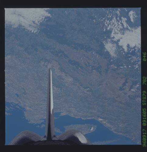
Image Caption: STS079-782-046 Dinaric Alps, Croatia; Bosnia-Herzecovina September 1996
A section of the rugged Dinaric Alps are visible in this south-looking view. The Dinaric Alps that extend 400 miles (645 km) along the coast of the Adriatic Sea, are composed of limestone and dolomite and are a barrier to travel from the coast to the interior; there are no natural passes. The partially submerged western part of the Dinaric Alps forms the numerous islands and harbors (upper portion of the image) along the Croatian coast. Sinkholes and caverns dominate the landscape. The region is sparsely populated and forestry and mining are the chief economic activities.
A section of the rugged Dinaric Alps are visible in this south-looking view. The Dinaric Alps that extend 400 miles (645 km) along the coast of the Adriatic Sea, are composed of limestone and dolomite and are a barrier to travel from the coast to the interior; there are no natural passes. The partially submerged western part of the Dinaric Alps forms the numerous islands and harbors (upper portion of the image) along the Croatian coast. Sinkholes and caverns dominate the landscape. The region is sparsely populated and forestry and mining are the chief economic activities.
