STS062-98-155

| NASA Photo ID | STS062-98-155 |
| Focal Length | 250mm |
| Date taken | 1994.03.12 |
| Time taken | 16:32:26 GMT |
Resolutions offered for this image:
3907 x 3872 pixels 640 x 634 pixels 5700 x 5900 pixels 500 x 518 pixels 640 x 480 pixels
3907 x 3872 pixels 640 x 634 pixels 5700 x 5900 pixels 500 x 518 pixels 640 x 480 pixels

Cloud masks available for this image:
Spacecraft nadir point: 38.6° N, 121.5° W
Photo center point: 38.0° N, 122.5° W
Photo center point by machine learning:
Photo center point: 38.0° N, 122.5° W
Photo center point by machine learning:
Nadir to Photo Center: Southwest
Spacecraft Altitude: 160 nautical miles (296km)
Country or Geographic Name: | USA-CALIFORNIA |
Features: | SAN FRANCISCO BAY AREA |
| Features Found Using Machine Learning: | |
Cloud Cover Percentage: | 0 (no clouds present) |
Sun Elevation Angle: | 24° |
Sun Azimuth: | 115° |
Camera: | Hasselblad |
Focal Length: | 250mm |
Camera Tilt: | 24 degrees |
Format: | 5048: Kodak, natural color positive, Lumiere 100x/5048, ASA 100x, standard base |
Film Exposure: | Normal |
| Additional Information | |
| Width | Height | Annotated | Cropped | Purpose | Links |
|---|---|---|---|---|---|
| 3907 pixels | 3872 pixels | No | No | Earth From Space collection | Download Image |
| 640 pixels | 634 pixels | No | No | Earth From Space collection | Download Image |
| 5700 pixels | 5900 pixels | No | No | Download Image | |
| 500 pixels | 518 pixels | No | No | Download Image | |
| 640 pixels | 480 pixels | No | No | Download Image |
Download Packaged File
Download a Google Earth KML for this Image
View photo footprint information
Download a GeoTIFF for this photo
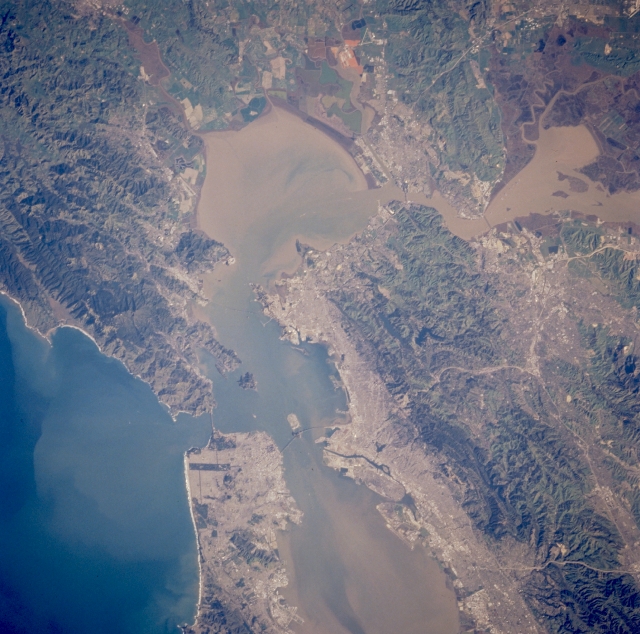
Image Caption: STS062-098-155 San Pablo Bay and San Francisco Bay, California, U.S.A. March 1994
Along with the rugged ridges and hills in this near-vertical, synoptic photograph of San Francisco, a number of bays are evident--elongated San Francisco Bay, oval San Pablo Bay north of San Francisco Bay, and smaller Suisun Bay and Grizzly Bay east of San Pablo Bay. Richmond, along the eastern shore of San Francisco Bay, sits on a peninsula that separates San Pablo Bay from San Francisco Bay. Two marshy areas are visible to the north and northeast--dark Grizzly Island, traversed by many sloughs, and the green and orange diked areas of salt extraction or mining, similar to the pattern of salt mining activities along southern San Francisco Bay.
Along with the rugged ridges and hills in this near-vertical, synoptic photograph of San Francisco, a number of bays are evident--elongated San Francisco Bay, oval San Pablo Bay north of San Francisco Bay, and smaller Suisun Bay and Grizzly Bay east of San Pablo Bay. Richmond, along the eastern shore of San Francisco Bay, sits on a peninsula that separates San Pablo Bay from San Francisco Bay. Two marshy areas are visible to the north and northeast--dark Grizzly Island, traversed by many sloughs, and the green and orange diked areas of salt extraction or mining, similar to the pattern of salt mining activities along southern San Francisco Bay.
