NM22-720-19
| NASA Photo ID | NM22-720-19 |
| Focal Length | 100mm |
| Date taken | 1996.09.__ |
| Time taken | GMT |
Resolutions offered for this image:
4064 x 4096 pixels 635 x 640 pixels 5700 x 6000 pixels 500 x 526 pixels
4064 x 4096 pixels 635 x 640 pixels 5700 x 6000 pixels 500 x 526 pixels


Cloud masks available for this image:
Spacecraft nadir point:
Photo center point: 51.5° S, 58.0° W
Photo center point by machine learning:
Photo center point: 51.5° S, 58.0° W
Photo center point by machine learning:
Nadir to Photo Center:
Spacecraft Altitude: nautical miles (0km)
Country or Geographic Name: | FALKLAND ISLANDS |
Features: | BERKLEY SOUND, BAYS |
| Features Found Using Machine Learning: | |
Cloud Cover Percentage: | 5 (1-10)% |
Sun Elevation Angle: | ° |
Sun Azimuth: | ° |
Camera: | Hasselblad |
Focal Length: | 100mm |
Camera Tilt: | Low Oblique |
Format: | 5046: Kodak, natural color positive, Lumiere 100/5046, ASA 100, standard base |
Film Exposure: | Normal |
| Additional Information | |
| Width | Height | Annotated | Cropped | Purpose | Links |
|---|---|---|---|---|---|
| 4064 pixels | 4096 pixels | No | No | Earth From Space collection | Download Image |
| 635 pixels | 640 pixels | No | No | Earth From Space collection | Download Image |
| 5700 pixels | 6000 pixels | No | No | Download Image | |
| 500 pixels | 526 pixels | No | No | Download Image |
Download Packaged File
Download a Google Earth KML for this Image
View photo footprint information
Download a GeoTIFF for this photo
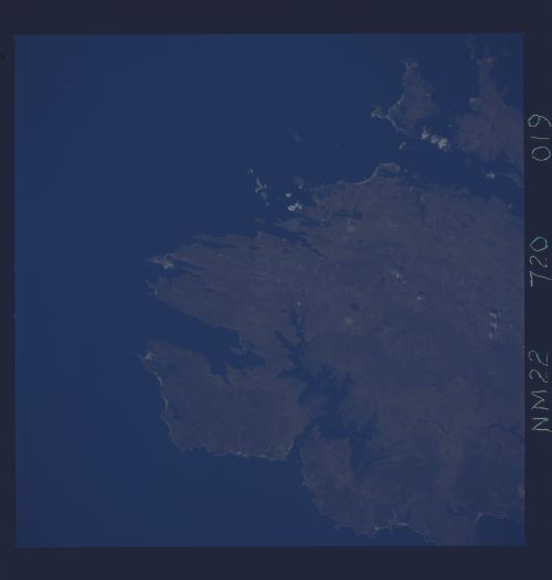
Image Caption: NM22-720-019 East Falkland Island, Falkland Islands, United Kingdom Fall/Winter 1996
Located in the south Atlantic Ocean, approximately 400 miles (644 kilometers) off of the extreme southeast coast of South America, the Falkland Islands consists of roughly 200 small islands plus the two much larger islands of East and West Falkland Island. As seen in this view of northeast East Falkland Island, the coastline is deeply indented and the terrain is generally rocky and hilly, with low mountains and some boggy, undulating plains. The islands have a cold, marine climate characterized by strong westerly winds and an average of 25 inches (635 mm) of precipitation distributed evenly throughout the year. The Falklands were the object of the 1982 military conflict between the United Kingdom and Argentina.
Located in the south Atlantic Ocean, approximately 400 miles (644 kilometers) off of the extreme southeast coast of South America, the Falkland Islands consists of roughly 200 small islands plus the two much larger islands of East and West Falkland Island. As seen in this view of northeast East Falkland Island, the coastline is deeply indented and the terrain is generally rocky and hilly, with low mountains and some boggy, undulating plains. The islands have a cold, marine climate characterized by strong westerly winds and an average of 25 inches (635 mm) of precipitation distributed evenly throughout the year. The Falklands were the object of the 1982 military conflict between the United Kingdom and Argentina.
