ISS067-E-373247

| NASA Photo ID | ISS067-E-373247 |
| Focal Length | 1150mm |
| Date taken | 2022.09.19 |
| Time taken | 23:06:49 GMT |
3712 x 4898 pixels 720 x 950 pixels 5568 x 3712 pixels 640 x 427 pixels
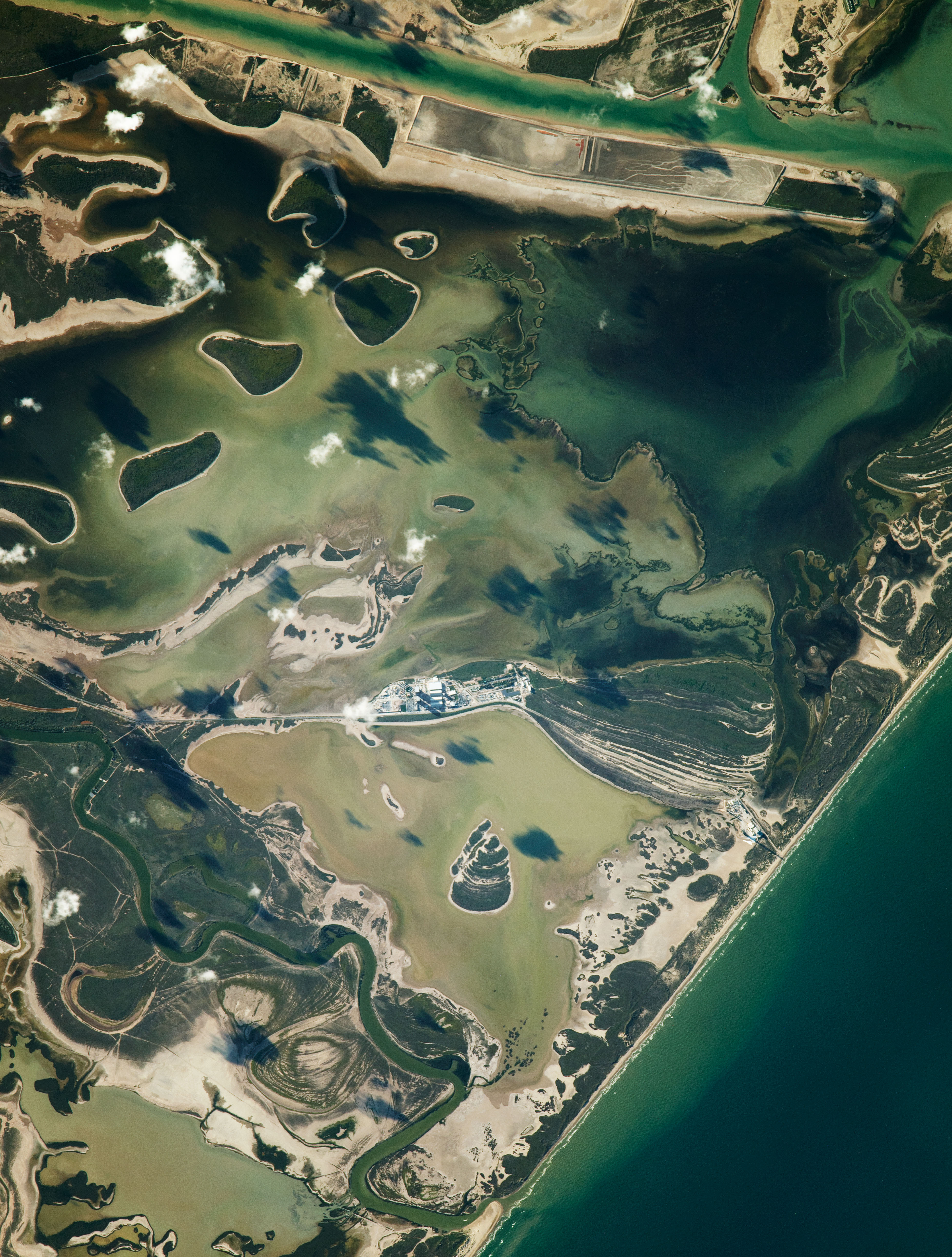
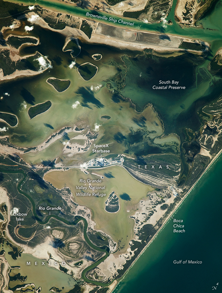
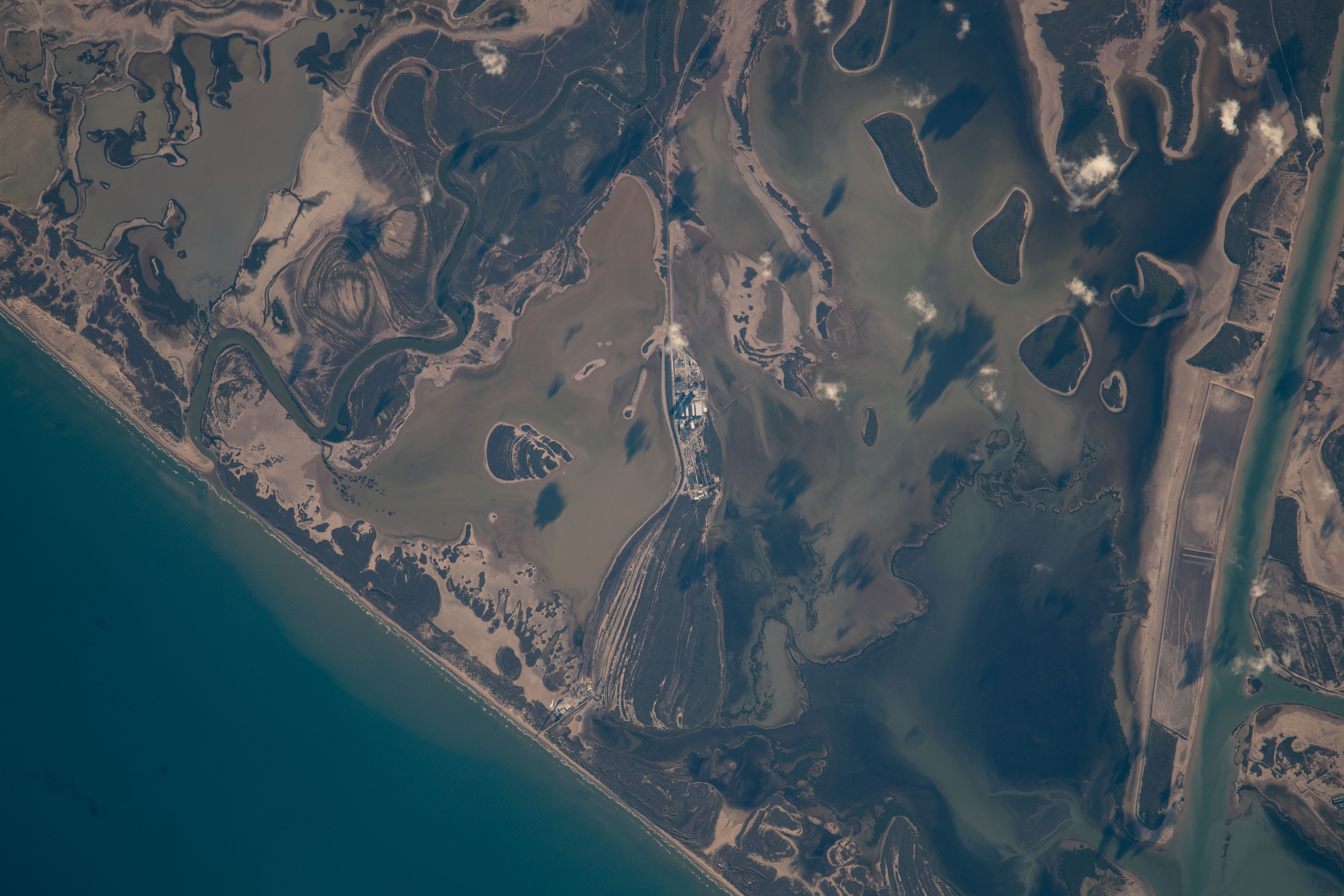

Photo center point: 26.0° N, 97.2° W
Photo center point by machine learning: 25.99° N, 97.18° W

Country or Geographic Name: | USA-TEXAS |
Features: | RIO GRANDE, SOUTH BAY, SEDIMENT, LAS PALOMAS WILDLIFE MANAGEMENT AREA, COAST, BOCA CHICA STATE PARK |
| Features Found Using Machine Learning: | |
Cloud Cover Percentage: | 10 (1-10)% |
Sun Elevation Angle: | 16° |
Sun Azimuth: | 263° |
Camera: | Nikon D5 Electronic Still Camera |
Focal Length: | 1150mm |
Camera Tilt: | 19 degrees |
Format: | 5568E: 5568 x 3712 pixel CMOS sensor, 35.9 x 23.9 mm, total pixels: 21.33 million, Nikon FX format |
Film Exposure: | |
| Additional Information | |
| Width | Height | Annotated | Cropped | Purpose | Links |
|---|---|---|---|---|---|
| 3712 pixels | 4898 pixels | No | Yes | NASA's Earth Observatory web site | Download Image |
| 720 pixels | 950 pixels | Yes | Yes | NASA's Earth Observatory web site | Download Image |
| 5568 pixels | 3712 pixels | No | No | Download Image | |
| 640 pixels | 427 pixels | No | No | Download Image |
An astronaut on the International Space Station captured this photo near the southernmost part of Texas. The image features the lower segment of the Rio Grande that defines a portion of the U.S.-Mexico border.
Prior rainfall delivered light-colored sediment into the surrounding coastal wetlands near the SpaceX Starbase. Sediment also entered the Brownsville Ship Channel and South Bay Coastal Preserve, a nursery area for fish, shellfish, and dolphins.
Along Boca Chica Beach, sediment is carried from the mouth of the Rio Grande into the Gulf of Mexico. The Rio Grande frequently transports sediment which causes buildup in the bends of the river. The sediment buildup can disrupt water flow, redirect the river path, and result in detached bends called oxbow lakes.
Adjacent to the lower 275 river miles (442 kilometers) of the Rio Grande is the Lower Rio Grande Valley National Wildlife Refuge. This refuge serves as a wildlife corridor that preserves biodiversity in the region and protects endangered species such as the ocelot.
Also visible in this image is the Las Palomas Wildlife Management Area, which includes most of the coastal wetlands centered in this photo. The management area conserves white-winged dove nesting habitat and manages wetlands for wildlife.
