ISS051-E-12590

| NASA Photo ID | ISS051-E-12590 |
| Focal Length | 1150mm |
| Date taken | 2017.04.11 |
| Time taken | 19:17:48 GMT |
4928 x 3280 pixels 720 x 480 pixels 4928 x 3280 pixels 640 x 426 pixels
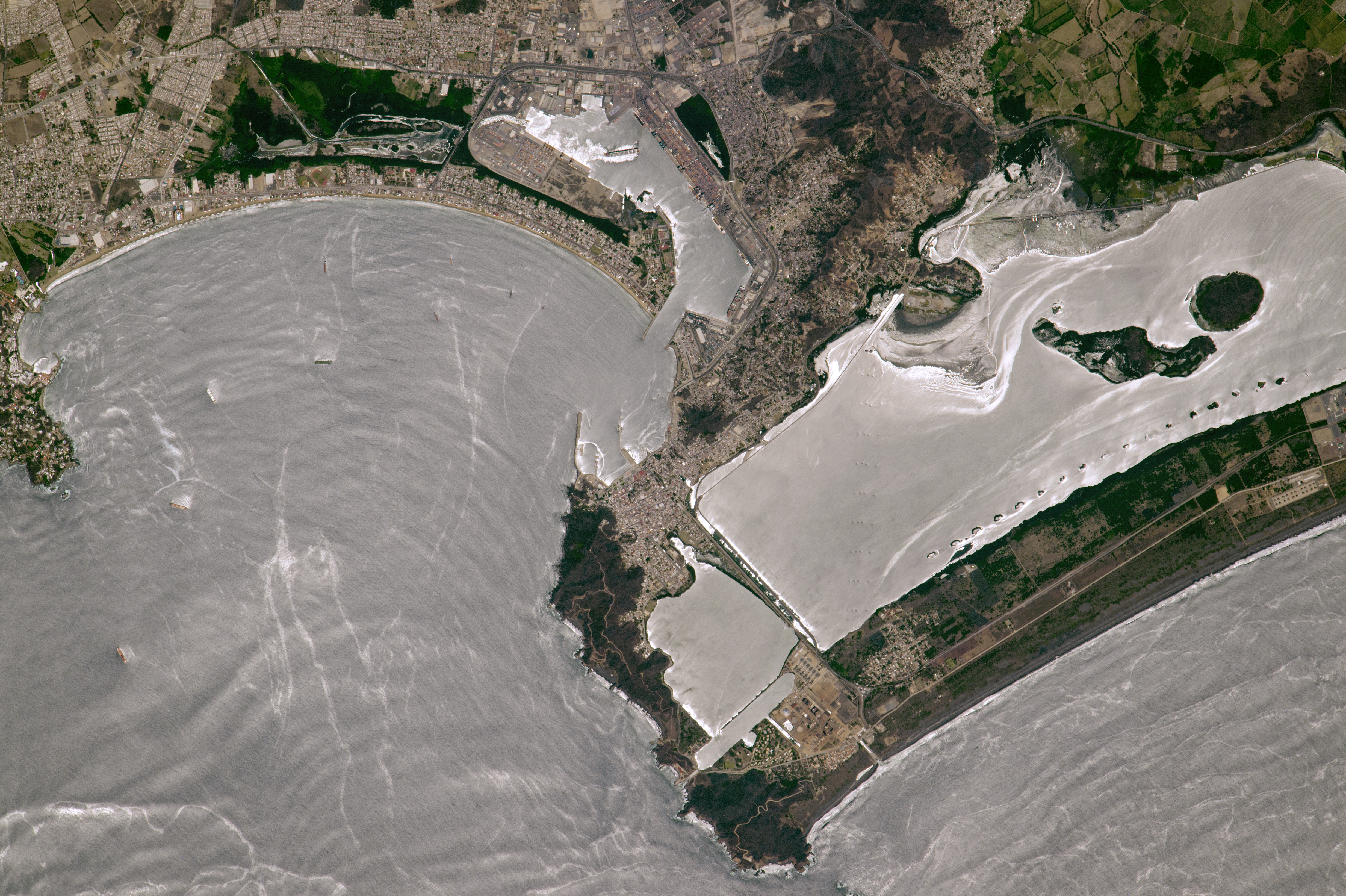
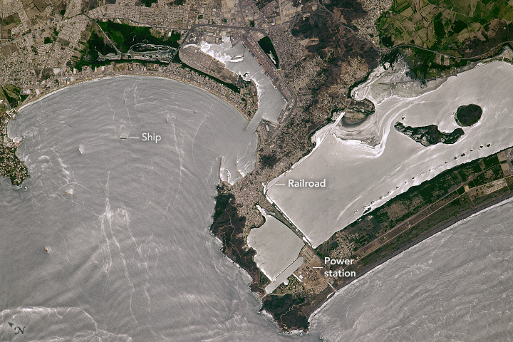
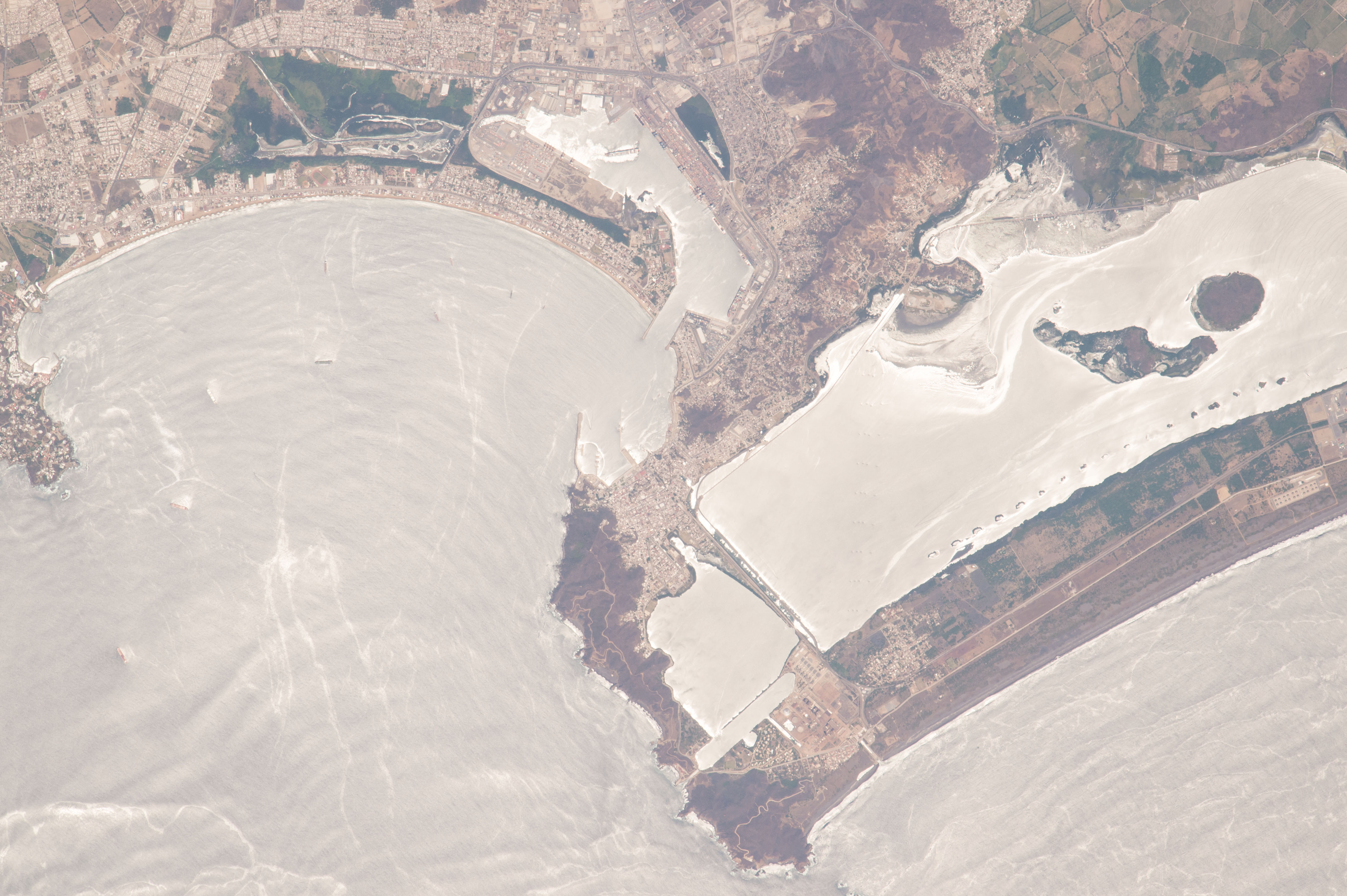


Photo center point: 19.0° N, 104.3° W
Photo center point by machine learning:
Country or Geographic Name: | MEXICO |
Features: | MANZANILLO CITY, PORT, BAYS, SUN GLINT |
| Features Found Using Machine Learning: | |
Cloud Cover Percentage: | 10 (1-10)% |
Sun Elevation Angle: | 78° |
Sun Azimuth: | 205° |
Camera: | Nikon D4 Electronic Still Camera |
Focal Length: | 1150mm |
Camera Tilt: | 11 degrees |
Format: | 4928E: 4928 x 3280 pixel CMOS sensor, 36.0mm x 23.9mm, total pixels: 16.6 million, Nikon FX format |
Film Exposure: | |
| Additional Information | |
| Width | Height | Annotated | Cropped | Purpose | Links |
|---|---|---|---|---|---|
| 4928 pixels | 3280 pixels | No | No | NASA's Earth Observatory web site | Download Image |
| 720 pixels | 480 pixels | Yes | No | NASA's Earth Observatory web site | Download Image |
| 4928 pixels | 3280 pixels | No | No | Download Image | |
| 640 pixels | 426 pixels | No | No | Download Image |
An astronaut took this photograph of Mexico's busiest port - Manzanillo - from the International Space Station. The port handles cargo for Mexico City, which is 600 kilometers (400 miles) to the east. With a population of 185,000 people, the city spreads along a complex coastline. Numerous tourist hotels situated along a curved sand spit dot the seafront and the main beach.
The harbor zone near the city center is protected by sea walls, and the larger harbor zone is protected by another sand spit. This is the main commercial harbor, and it also hosts ships from Mexico's naval fleet. An artificial channel gives sea access, and the bay's shoreline is heavily engineered for port functions.
A power station occupies one end of one of the sand spits. A railroad causeway has been built over the water of Laguna Cuyutlan around the inner shorelines of the lake to supply the power station with fuel. A detailed version of the image shows two lines of power transmission pylons that angle from the power station inland across the lake.
This image was taken looking near the Sun's reflection point, or "glint point," so it reveals several ocean features. Broad curves show ocean swells moving onshore. The bright filaments may be surfactants from biogenic oils, and perhaps also from bilge pumping from the numerous oil tankers that use the port. Ships often anchor in the bay near the harbor, waiting to discharge or take on cargo.
