ISS024-E-12815
| NASA Photo ID | ISS024-E-12815 |
| Focal Length | 55mm |
| Date taken | 2010.08.30 |
| Time taken | 21:28:21 GMT |

Cloud masks available for this image:
Spacecraft nadir point: 27.8° N, 68.2° W
Photo center point: 19.5° N, 64.5° W
Photo center point by machine learning:
Photo center point: 19.5° N, 64.5° W
Photo center point by machine learning:
Nadir to Photo Center: South
Spacecraft Altitude: 189 nautical miles (350km)
Country or Geographic Name: | ATLANTIC OCEAN |
Features: | PAN-HURRICANE EARL, EYE, SPIRAL BANDS, SEA SURFACE, ISS |
| Features Found Using Machine Learning: | PAN- |
Cloud Cover Percentage: | 100 (76-100)% |
Sun Elevation Angle: | 18° |
Sun Azimuth: | 270° |
Camera: | Nikon D3X Electronic Still Camera |
Focal Length: | 55mm |
Camera Tilt: | High Oblique |
Format: | 6048E: 6048 x 4032 pixel CMOS sensor, 35.9mm x 24.0mm, total pixels: 25.72 million, Nikon FX format |
Film Exposure: | |
| Additional Information | |
| Width | Height | Annotated | Cropped | Purpose | Links |
|---|---|---|---|---|---|
| 1600 pixels | 1097 pixels | No | No | Download Image | |
| 640 pixels | 439 pixels | No | No | Download Image |
Download Packaged File
Download a Google Earth KML for this Image
View photo footprint information
Download a GeoTIFF for this photo
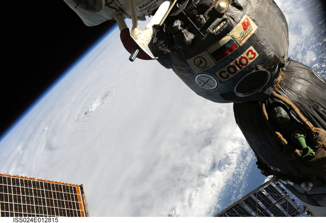
Image Caption: ISS024-E-012815 (30 Aug. 2010) --? Photographed by an Expedition 24 crew member on the International Space Station, this is an oblique view that shows the eye (just left of center) of Hurricane Earl (at this time a category 4 but later downgraded to a category 3), centered just north of the Virgin Islands near 19.3 north latitude and 64.7 west longitude packing 115-kilometer winds. A Russian Soyuz vehicle is docked to the station (foreground). The photo was taken with a digital still camera using a 55mm lens.
