ISS004-E-7267

| NASA Photo ID | ISS004-E-7267 |
| Focal Length | 400mm |
| Date taken | 2002.02.07 |
| Time taken | 15:02:13 GMT |
Resolutions offered for this image:
1024 x 767 pixels 540 x 404 pixels 540 x 424 pixels 540 x 425 pixels 540 x 426 pixels 540 x 855 pixels 3032 x 2064 pixels 639 x 435 pixels
1024 x 767 pixels 540 x 404 pixels 540 x 424 pixels 540 x 425 pixels 540 x 426 pixels 540 x 855 pixels 3032 x 2064 pixels 639 x 435 pixels

Cloud masks available for this image:
Spacecraft nadir point: 46.5° S, 74.9° W
Photo center point: 47.0° S, 74.0° W
Photo center point by machine learning:
Photo center point: 47.0° S, 74.0° W
Photo center point by machine learning:
Nadir to Photo Center: Southeast
Spacecraft Altitude: 212 nautical miles (393km)
Country or Geographic Name: | CHILE |
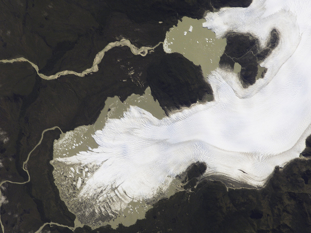
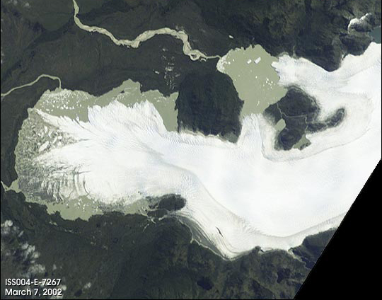
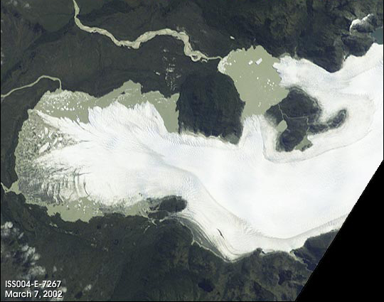
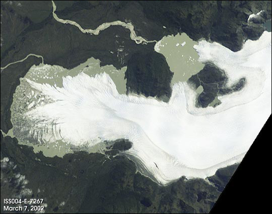
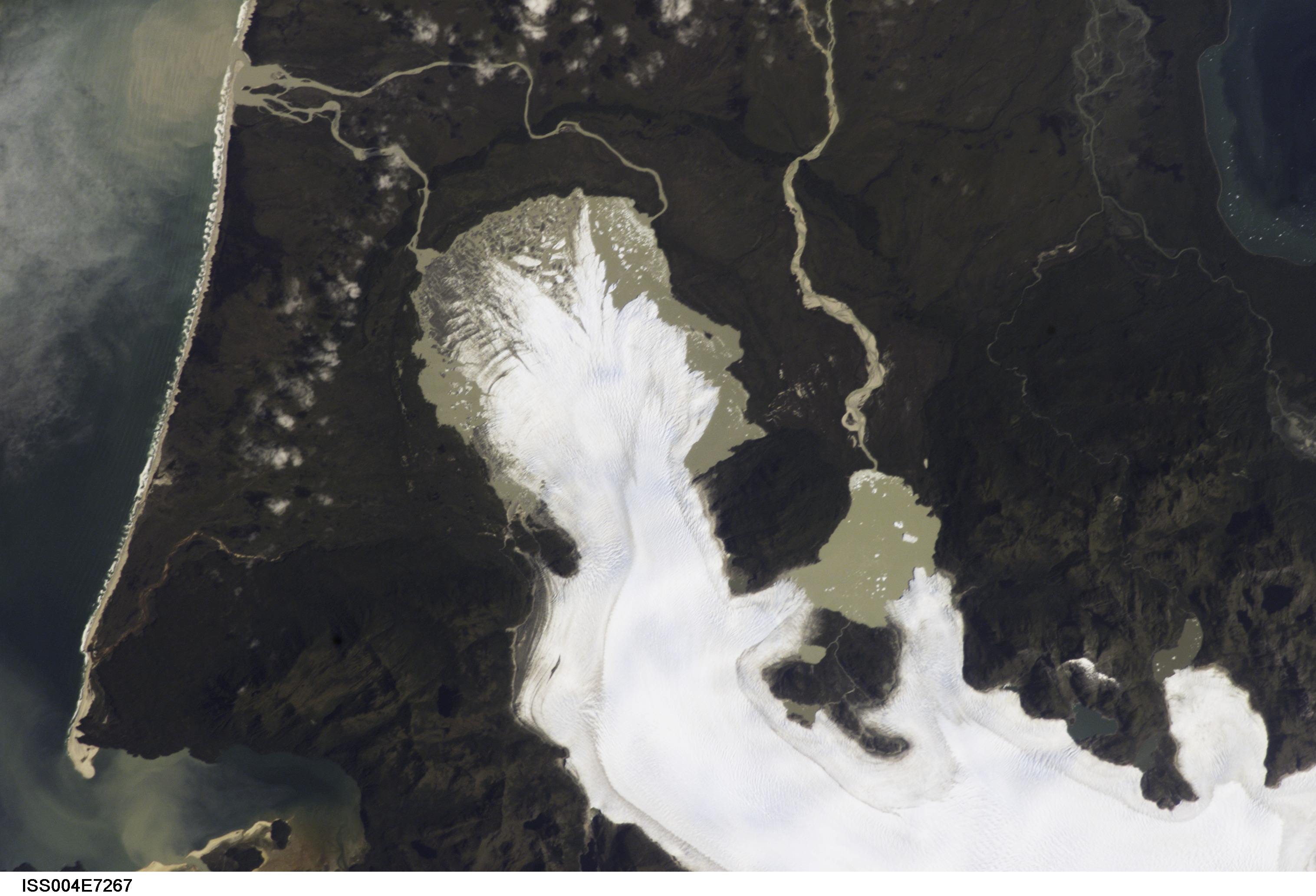
Features: | SAN QUINTIN GLACIER |
| Features Found Using Machine Learning: | |
Cloud Cover Percentage: | 10 (1-10)% |
Sun Elevation Angle: | 49° |
Sun Azimuth: | 52° |
Camera: | Kodak DCS760c Electronic Still Camera |
Focal Length: | 400mm |
Camera Tilt: | 16 degrees |
Format: | 3060E: 3060 x 2036 pixel CCD, RGBG array |
Film Exposure: | |
| Additional Information | |
| Width | Height | Annotated | Cropped | Purpose | Links |
|---|---|---|---|---|---|
| 1024 pixels | 767 pixels | Photographic Highlights | Download Image | ||
| 540 pixels | 404 pixels | Photographic Highlights | Download Image | ||
| 540 pixels | 424 pixels | Yes | Yes | NASA's Earth Observatory web site | Download Image |
| 540 pixels | 425 pixels | Yes | Yes | NASA's Earth Observatory web site | Download Image |
| 540 pixels | 426 pixels | Yes | Yes | Download Image | |
| 540 pixels | 855 pixels | Yes | Yes | NASA's Earth Observatory web site | Download Image |
| 3032 pixels | 2064 pixels | No | No | Download Image | |
| 639 pixels | 435 pixels | No | No | Download Image |
Download Packaged File
Download a Google Earth KML for this Image
View photo footprint information
Download a GeoTIFF for this photo
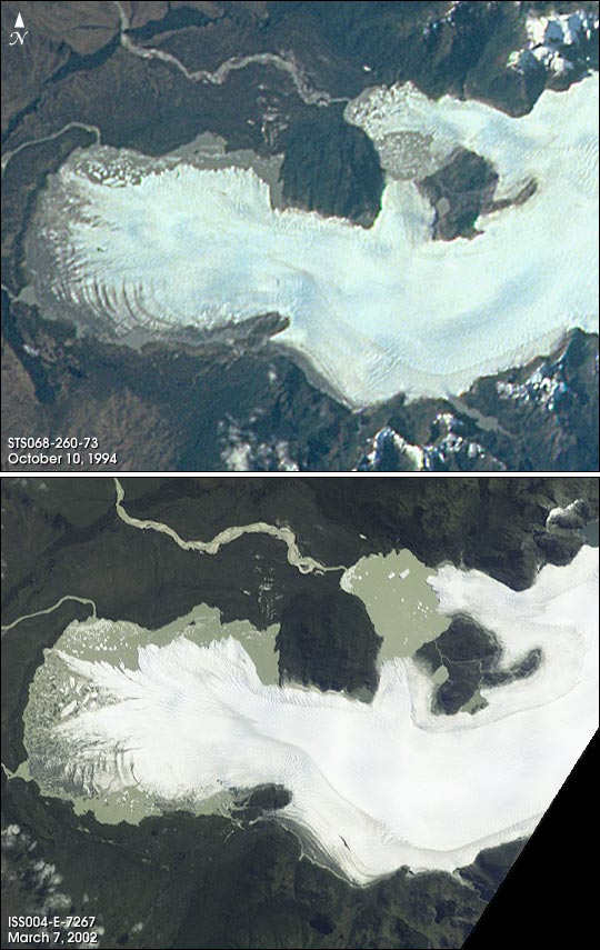
Image Caption: The San Quintin Glacier is the largest outflow glacier of the Northern Patagonian Ice Field in southern Chile. Its terminus is a piedmont lobe just short of the Golfo de Penas on the Pacific Ocean and just north of 47degS. Like many glaciers worldwide during the twentieth century, San Quintin appears to be losing mass and possibly retreating. Such a change is evident in these two photographs taken by astronauts only seven years apart. The first was taken by the crew of STS-068 in October 1994 (STS068-260-73) and the second by the Increment 4 crew of the International Space Station in February 2002.
Even with the reversal of season and different lighting conditions of these two acquisitions, a loss of mass and change of structure, particularly in the lobe, are strikingly evident in these comparative photos. Glaciers are one of the special topics identified as scientific objectives for monitoring with photography from the International Space Station. Astronaut photography is a complimentary source of remote sensing data available for use with other sensor systems being used to monitor and study glaciers. They also provide strong, visual context information on glacier environments and processes using a familiar medium, the camera.
Even with the reversal of season and different lighting conditions of these two acquisitions, a loss of mass and change of structure, particularly in the lobe, are strikingly evident in these comparative photos. Glaciers are one of the special topics identified as scientific objectives for monitoring with photography from the International Space Station. Astronaut photography is a complimentary source of remote sensing data available for use with other sensor systems being used to monitor and study glaciers. They also provide strong, visual context information on glacier environments and processes using a familiar medium, the camera.
