ISS002-E-8683

| NASA Photo ID | ISS002-E-8683 |
| Focal Length | 70mm |
| Date taken | 2001.__.__ |
| Time taken | GMT |
Resolutions offered for this image:
540 x 359 pixels 3060 x 2035 pixels 3060 x 2092 pixels 640 x 437 pixels 400 x 266 pixels
540 x 359 pixels 3060 x 2035 pixels 3060 x 2092 pixels 640 x 437 pixels 400 x 266 pixels

Cloud masks available for this image:
Spacecraft nadir point:
Photo center point: 38.0° N, 15.0° E
Photo center point by machine learning:
Photo center point: 38.0° N, 15.0° E
Photo center point by machine learning:
Nadir to Photo Center:
Spacecraft Altitude: nautical miles (0km)
Country or Geographic Name: | SICILY |
Features: | MOUNT ETNA, SMOKE PLUME |
| Features Found Using Machine Learning: | |
Cloud Cover Percentage: | 10 (1-10)% |
Sun Elevation Angle: | ° |
Sun Azimuth: | ° |
Camera: | Kodak DCS460 Electronic Still Camera |
Focal Length: | 70mm |
Camera Tilt: | |
Format: | 3060E: 3060 x 2036 pixel CCD, RGBG array |
Film Exposure: | |
| Additional Information | |
| Width | Height | Annotated | Cropped | Purpose | Links |
|---|---|---|---|---|---|
| 540 pixels | 359 pixels | Yes | No | Earth From Space collection | Download Image |
| 3060 pixels | 2035 pixels | No | No | NASA's Earth Observatory web site | Download Image |
| 3060 pixels | 2092 pixels | No | No | Download Image | |
| 640 pixels | 437 pixels | No | No | Download Image | |
| 400 pixels | 266 pixels | Yes | No | Photographic Highlights | Download Image |
Download Packaged File
Download a Google Earth KML for this Image
View photo footprint information
Download a GeoTIFF for this photo
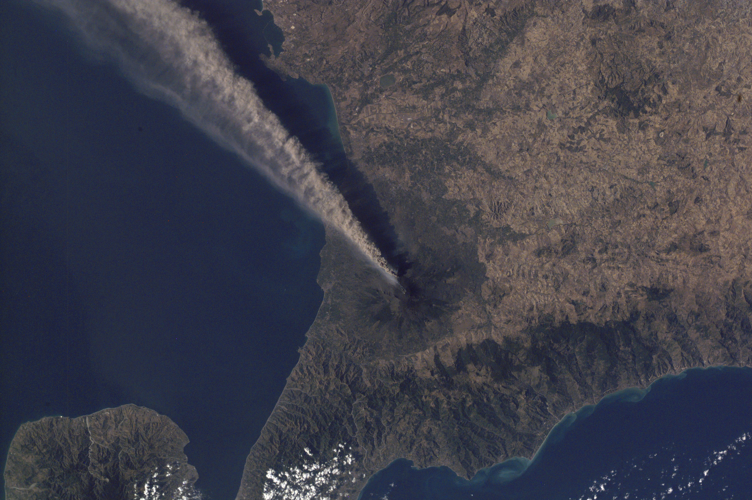
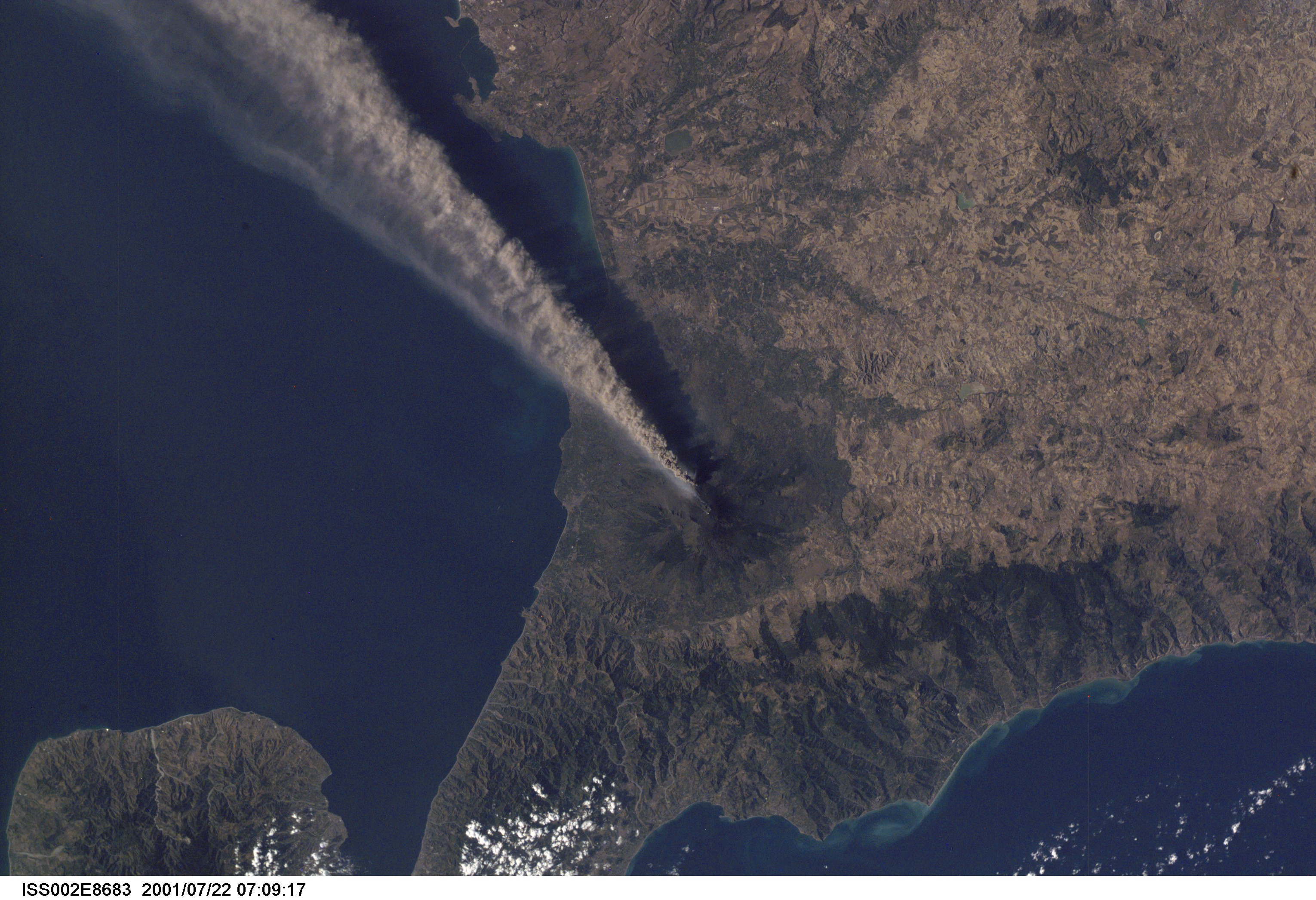
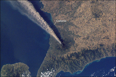
Image Caption: When this southward-looking photograph was taken by the Expedition 2 crew aboard the International Space Station, the city of Catania (in shadow, ~25 km SSE of the volcano) was covered by a layer of ash and Fontanarossa International Airport was closed. On that day an ash cloud was reported to have reached a maximum height of ~5.2 km. Plumes from two sources are visible here--a dense, darker mass from one of the three summit craters and a lighter, lower one.
The record of historical volcanism of Mt. Etna is one of the longest in the world, dating back to 1500 BC. Two styles of activity are typical: explosive eruptions, sometimes with minor lava flows, from the summit craters and flank eruptions from fissures.
The record of historical volcanism of Mt. Etna is one of the longest in the world, dating back to 1500 BC. Two styles of activity are typical: explosive eruptions, sometimes with minor lava flows, from the summit craters and flank eruptions from fissures.
