< STS078-742-74 >
| NASA Photo ID | STS078-742-74 |
| Focal Length | 250mm |
| Date taken | 1996.07.02 |
| Time taken | 06:56:41 GMT |
Resolutions offered for this image:
4041 x 4028 pixels 639 x 637 pixels 5700 x 5900 pixels 483 x 500 pixels 521 x 508 pixels
4041 x 4028 pixels 639 x 637 pixels 5700 x 5900 pixels 483 x 500 pixels 521 x 508 pixels


Cloud masks available for this image:
Spacecraft nadir point: 32.4° N, 35.7° E
Photo center point: 33.5° N, 35.5° E
Photo center point by machine learning:
Photo center point: 33.5° N, 35.5° E
Photo center point by machine learning:
Nadir to Photo Center: North
Spacecraft Altitude: 141 nautical miles (261km)
Camera: | Hasselblad |
Focal Length: | 250mm |
Camera Tilt: | 25 degrees |
Format: | 5046: Kodak, natural color positive, Lumiere 100/5046, ASA 100, standard base |
Film Exposure: | Normal |
| Additional Information | |
| Width | Height | Annotated | Cropped | Purpose | Links |
|---|---|---|---|---|---|
| 4041 pixels | 4028 pixels | No | No | Earth From Space collection | Download Image |
| 639 pixels | 637 pixels | No | No | Earth From Space collection | Download Image |
| 5700 pixels | 5900 pixels | No | No | Download Image Download Color Calibration Image for this Image |
|
| 483 pixels | 500 pixels | No | No | Download Image Download Color Calibration Image for this Image |
|
| 521 pixels | 508 pixels | Download Image |
Download Packaged File
Download a Google Earth KML for this Image
View photo footprint information
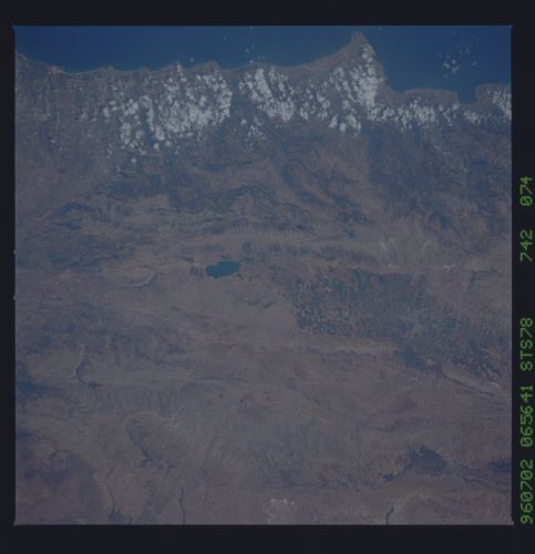
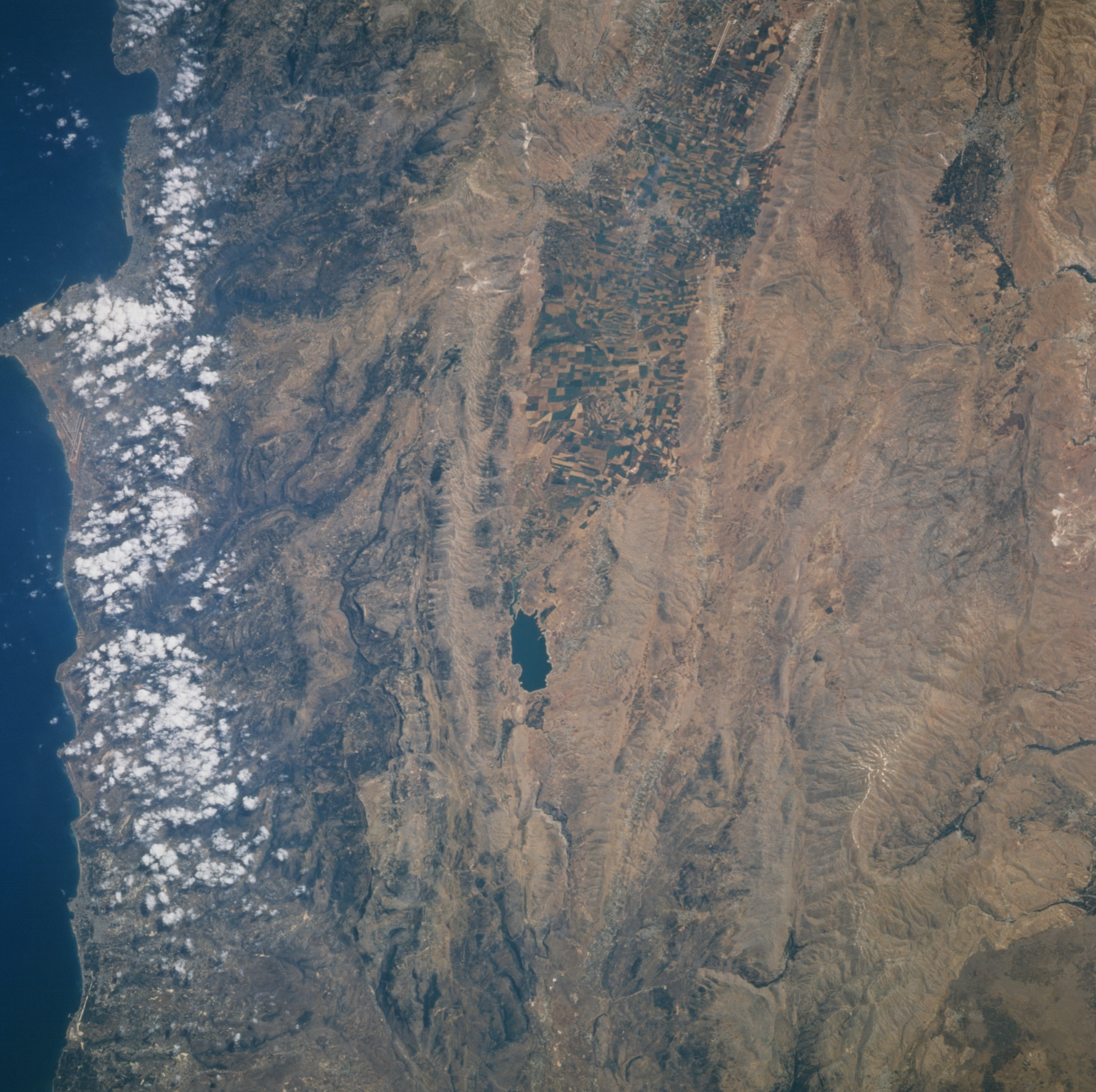
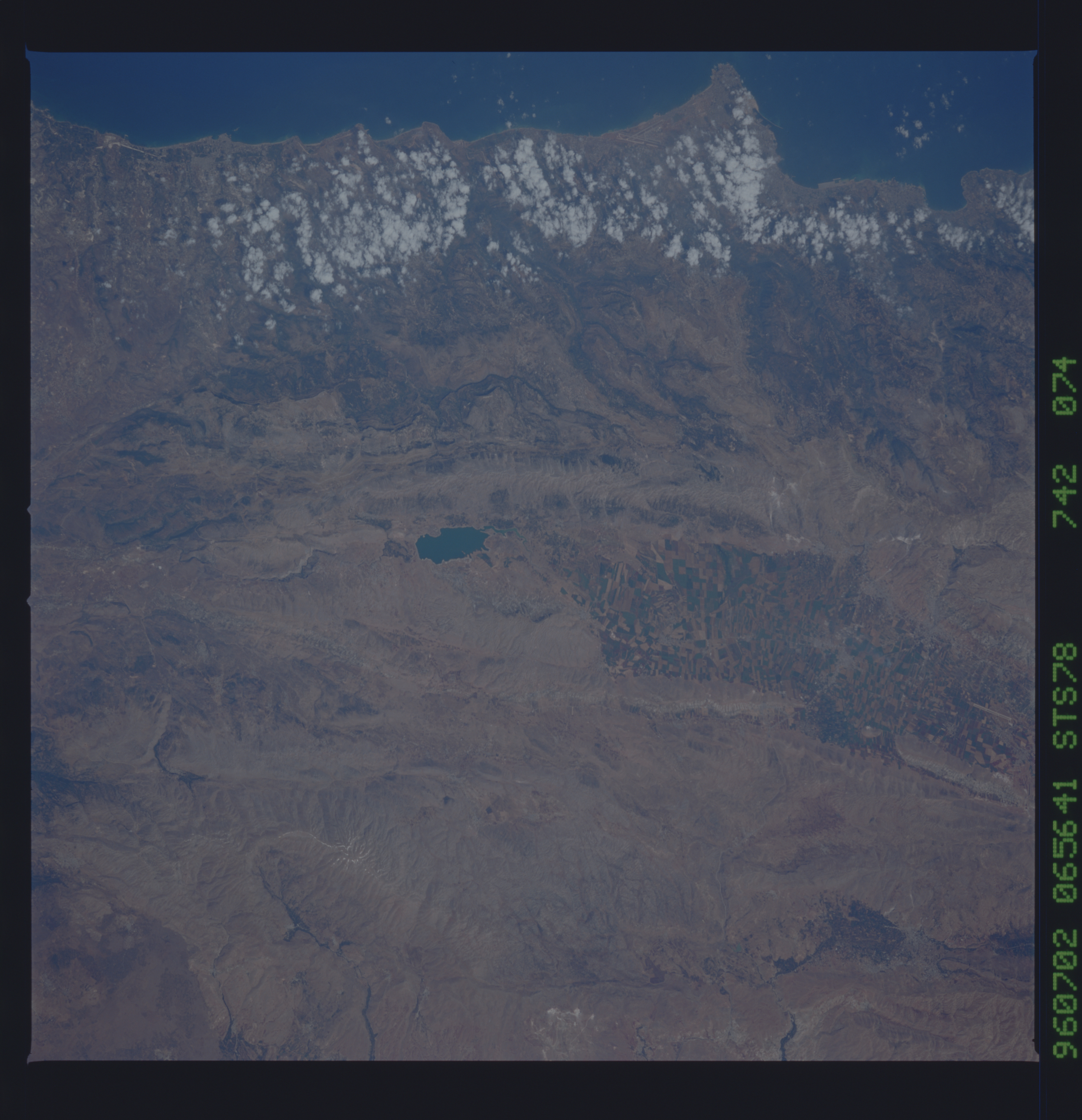
No GeoTIFF is available for this photo.Image Caption: STS078-742-074 The Biqa Valley, Lebanon June 1996
The upland Biqa Valley and the highest part of the Great Rift Valley, that covers an area from Syria southward to near Mozambique in southern Africa, can be seen in this near-nadir view. The Biqa Valley, which stretches north into Syria, is 75 miles (121 km) long and 5 to 9 miles (8 to 15 km) wide, and is located between the Lebanon Mountains to the west (left on the image), and the anti-Lebanon Mountains to the east (right on the image). The valley is Lebanon's chief agricultural area, as can be seen on the upper center of the image. The high and rugged Lebanon Mountains parallel the Mediterranean Coast. The mountains rise steeply from the coast and are over 100 miles (160 km) long. The Lebanon Mountains were famous in ancient times for their large, old cedar trees that extended in a narrow strip along the upper western slope of the range. Over 90 percent of these trees have been depleted, used for building materials and fuel. Only isolated groves remain. The anti-Lebanon Mountains extend north to south marking the border between Lebanon and Syria. Once known for their forests of oak, pine, cypress, and juniper, the range is mostly void of trees and is now largely stony and barren. The only permanent lake in Lebanon, Buhayrat (lake) Al Qirawn, is visible near the center of the image.
The upland Biqa Valley and the highest part of the Great Rift Valley, that covers an area from Syria southward to near Mozambique in southern Africa, can be seen in this near-nadir view. The Biqa Valley, which stretches north into Syria, is 75 miles (121 km) long and 5 to 9 miles (8 to 15 km) wide, and is located between the Lebanon Mountains to the west (left on the image), and the anti-Lebanon Mountains to the east (right on the image). The valley is Lebanon's chief agricultural area, as can be seen on the upper center of the image. The high and rugged Lebanon Mountains parallel the Mediterranean Coast. The mountains rise steeply from the coast and are over 100 miles (160 km) long. The Lebanon Mountains were famous in ancient times for their large, old cedar trees that extended in a narrow strip along the upper western slope of the range. Over 90 percent of these trees have been depleted, used for building materials and fuel. Only isolated groves remain. The anti-Lebanon Mountains extend north to south marking the border between Lebanon and Syria. Once known for their forests of oak, pine, cypress, and juniper, the range is mostly void of trees and is now largely stony and barren. The only permanent lake in Lebanon, Buhayrat (lake) Al Qirawn, is visible near the center of the image.
