< ISS038-E-47389 >
| NASA Photo ID | ISS038-E-47389 |
| Focal Length | 80mm |
| Date taken | 2014.02.14 |
| Time taken | 11:40:52 GMT |
Resolutions offered for this image:
1000 x 728 pixels 540 x 393 pixels 1440 x 960 pixels 720 x 480 pixels 4284 x 2844 pixels 640 x 425 pixels
1000 x 728 pixels 540 x 393 pixels 1440 x 960 pixels 720 x 480 pixels 4284 x 2844 pixels 640 x 425 pixels


Spacecraft nadir point: 51.6° S, 54.2° W
Photo center point: 55.5° S, 68.5° W
Photo center point by machine learning:
Photo center point: 55.5° S, 68.5° W
Photo center point by machine learning:
Nadir to Photo Center: West
Spacecraft Altitude: 228 nautical miles (422km)
Country or Geographic Name: | CHILE |
Features: | PAN-TIERRA DEL FUEGO |
| Features Found Using Machine Learning: | PAN- |
Cloud Cover Percentage: | 50 (26-50)% |
Sun Elevation Angle: | 27° |
Sun Azimuth: | 76° |
Camera: | Nikon D3 Electronic Still Camera |
Focal Length: | 80mm |
Camera Tilt: | High Oblique |
Format: | 4256E: 4256 x 2832 pixel CMOS sensor, 36.0mm x 23.9mm, total pixels: 12.87 million, Nikon FX format |
Film Exposure: | |
| Additional Information | |
| Width | Height | Annotated | Cropped | Purpose | Links |
|---|---|---|---|---|---|
| 1000 pixels | 728 pixels | No | No | Earth From Space collection | Download Image |
| 540 pixels | 393 pixels | Yes | No | Earth From Space collection | Download Image |
| 1440 pixels | 960 pixels | No | No | NASA's Earth Observatory web site | Download Image |
| 720 pixels | 480 pixels | Yes | No | NASA's Earth Observatory web site | Download Image |
| 4284 pixels | 2844 pixels | No | No | Download Image | |
| 640 pixels | 425 pixels | No | No | Download Image |
Download Packaged File
Download a Google Earth KML for this Image
View photo footprint information
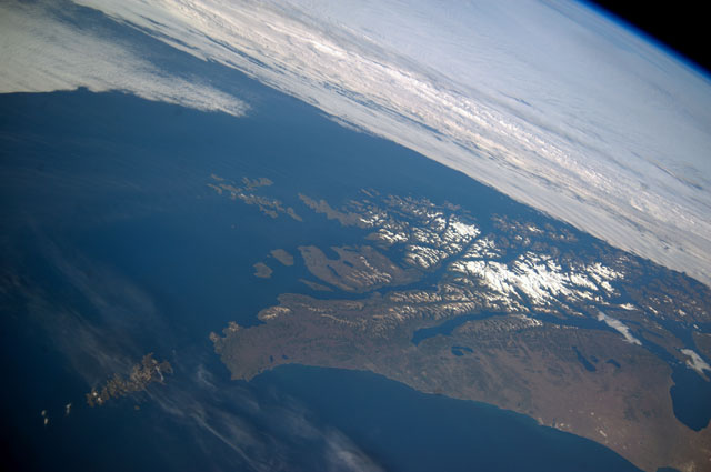
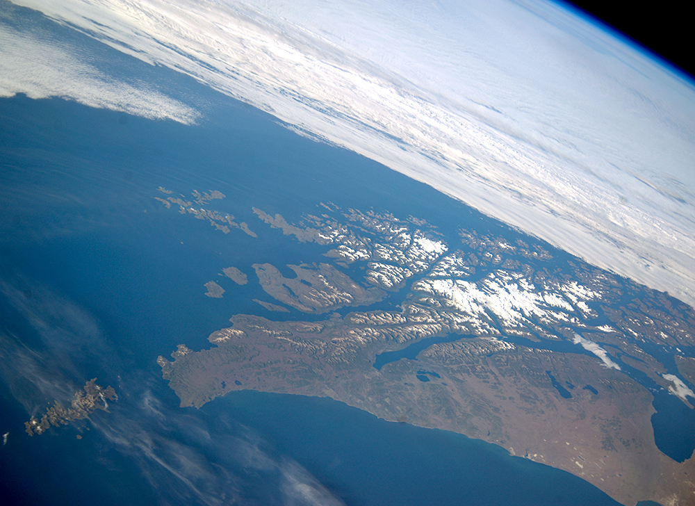
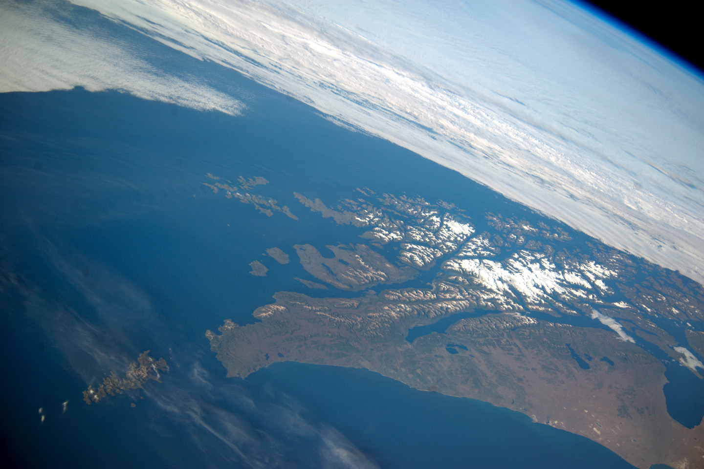
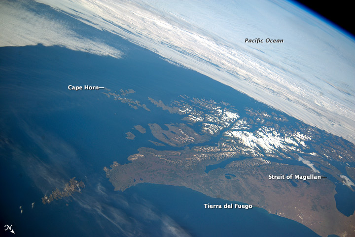
No GeoTIFF is available for this photo.Image Caption: Tierra del Fuego and Cape Horn, Argentina and Chile
This panoramic image from the International Space Station (ISS) captures Tierra del Fuego and Cape Horn, the southernmost tip of South America (image left), with the Atlantic Ocean in the foreground and the Pacific Ocean across the top of the image. Crews on the ISS seldom see Cape Horn in such clear weather. Shortly after this image was taken the cloud mass approaching from the Pacific Ocean completely obscured the landscape from ISS view. In this stormy part of the world, ships avoid the heavy seas around exposed Cape Horn and use the protected Strait of Magellan (image lower right) on the inshore end of Tierra del Fuego.
A small white icefield on the highest parts of Tierra del Fuego (image center right) includes Mount Darwin, situated within Chile's Agostini National Park. The icefield can be imagined as greatly expanded during the geologically recent ice ages, covering an area greater than the land area shown in this view. The heavily indented shape of the fiord coastline and the lake depressions (image center and lower right) were carved by the downhill movement of these vanished glaciers.
