ISS038-E-47388
| NASA Photo ID | ISS038-E-47388 |
| Focal Length | 200mm |
| Date taken | 2014.02.14 |
| Time taken | 12:16:20 GMT |
Resolutions offered for this image:
1000 x 688 pixels 540 x 372 pixels 4256 x 2832 pixels 720 x 480 pixels 4256 x 2832 pixels 640 x 426 pixels
1000 x 688 pixels 540 x 372 pixels 4256 x 2832 pixels 720 x 480 pixels 4256 x 2832 pixels 640 x 426 pixels


Spacecraft nadir point: 38.5° N, 57.9° E
Photo center point: 34.8° N, 55.0° E
Photo center point by machine learning:
Photo center point: 34.8° N, 55.0° E
Photo center point by machine learning:
Nadir to Photo Center: Southwest
Spacecraft Altitude: 221 nautical miles (409km)
Country or Geographic Name: | IRAN |
Features: | KAVIR DESERT, LAKE BEDS |
| Features Found Using Machine Learning: | |
Cloud Cover Percentage: | 10 (1-10)% |
Sun Elevation Angle: | 15° |
Sun Azimuth: | 239° |
Camera: | Nikon D3 Electronic Still Camera |
Focal Length: | 200mm |
Camera Tilt: | 52 degrees |
Format: | 4256E: 4256 x 2832 pixel CMOS sensor, 36.0mm x 23.9mm, total pixels: 12.87 million, Nikon FX format |
Film Exposure: | |
| Additional Information | |
| Width | Height | Annotated | Cropped | Purpose | Links |
|---|---|---|---|---|---|
| 1000 pixels | 688 pixels | No | Yes | Earth From Space collection | Download Image |
| 540 pixels | 372 pixels | Yes | Yes | Earth From Space collection | Download Image |
| 4256 pixels | 2832 pixels | No | No | NASA's Earth Observatory web site | Download Image |
| 720 pixels | 480 pixels | Yes | Yes | NASA's Earth Observatory web site | Download Image |
| 4256 pixels | 2832 pixels | No | No | Download Image | |
| 640 pixels | 426 pixels | No | No | Download Image |
Download Packaged File
Download a Google Earth KML for this Image
View photo footprint information
Download a GeoTIFF for this photo
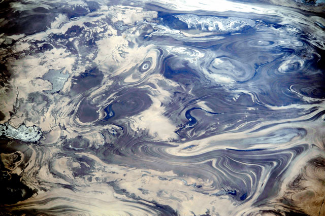
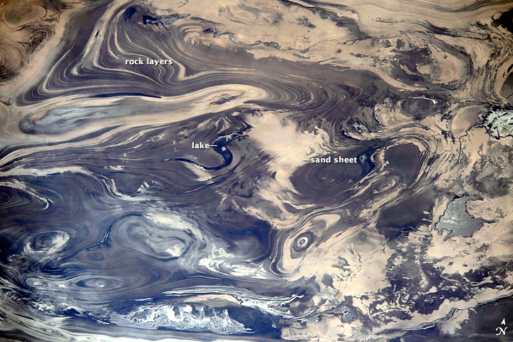
Image Caption: Kavir Desert, Iran
This striking pattern of numerous parallel lines and sweeping curves greets orbiting observers in the International Space Station as they pass over the deserts of central Iran. The lack of soil and vegetation allows the geological structure of the rocks to appear quite clearly. The patterns result from the gentle folding of numerous, thin, light and dark layers of rock. Later erosion by wind and water cut a flat surface across the folds, not only exposing hundreds of layers but also showing the shapes of the folds. The pattern has been likened to the layers of a sliced onion.
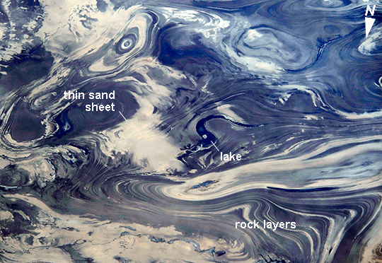
The dark water of a lake (image center) occupies a depression in a more easily eroded, S-shaped layer of rock. The irregular light-toned patch just left of the lake is a sand sheet thin enough to allow the underlying rock layers to be detected. A small river snakes across the bottom of the image. In this desert landscape there are no fields or roads to give a sense of scale. In fact, the image width represents a distance of 84 km.
This striking pattern of numerous parallel lines and sweeping curves greets orbiting observers in the International Space Station as they pass over the deserts of central Iran. The lack of soil and vegetation allows the geological structure of the rocks to appear quite clearly. The patterns result from the gentle folding of numerous, thin, light and dark layers of rock. Later erosion by wind and water cut a flat surface across the folds, not only exposing hundreds of layers but also showing the shapes of the folds. The pattern has been likened to the layers of a sliced onion.
The dark water of a lake (image center) occupies a depression in a more easily eroded, S-shaped layer of rock. The irregular light-toned patch just left of the lake is a sand sheet thin enough to allow the underlying rock layers to be detected. A small river snakes across the bottom of the image. In this desert landscape there are no fields or roads to give a sense of scale. In fact, the image width represents a distance of 84 km.
