< STS038-86-15 >
| NASA Photo ID | STS038-86-15 |
| Focal Length | 250mm |
| Date taken | 1990.11.18 |
| Time taken | 21:51:16 GMT |
Resolutions offered for this image:
3904 x 3862 pixels 639 x 633 pixels 5700 x 6000 pixels 500 x 526 pixels 640 x 480 pixels
3904 x 3862 pixels 639 x 633 pixels 5700 x 6000 pixels 500 x 526 pixels 640 x 480 pixels


Cloud masks available for this image:
Spacecraft nadir point: 26.6° N, 97.5° W
Photo center point: 26.0° N, 97.5° W
Photo center point by machine learning:
Photo center point: 26.0° N, 97.5° W
Photo center point by machine learning:
Nadir to Photo Center: South
Spacecraft Altitude: 116 nautical miles (215km)
Country or Geographic Name: | USA-TEXAS |
Features: | BROWNSVILLE SHIP CHANNEL, SEDIMENT |
| Features Found Using Machine Learning: | |
Cloud Cover Percentage: | 5 (1-10)% |
Sun Elevation Angle: | 20° |
Sun Azimuth: | 235° |
Camera: | Hasselblad |
Focal Length: | 250mm |
Camera Tilt: | 17 degrees |
Format: | 5017: Kodak, natural color positive, Ektachrome, X Professional, ASA 64, standard base |
Film Exposure: | Normal |
| Additional Information | |
| Width | Height | Annotated | Cropped | Purpose | Links |
|---|---|---|---|---|---|
| 3904 pixels | 3862 pixels | No | No | Earth From Space collection | Download Image |
| 639 pixels | 633 pixels | No | No | Earth From Space collection | Download Image |
| 5700 pixels | 6000 pixels | No | No | Download Image Download Color Calibration Image for this Image |
|
| 500 pixels | 526 pixels | No | No | Download Image Download Color Calibration Image for this Image |
|
| 640 pixels | 480 pixels | No | No | Download Image |
Download Packaged File
Download a Google Earth KML for this Image
View photo footprint information
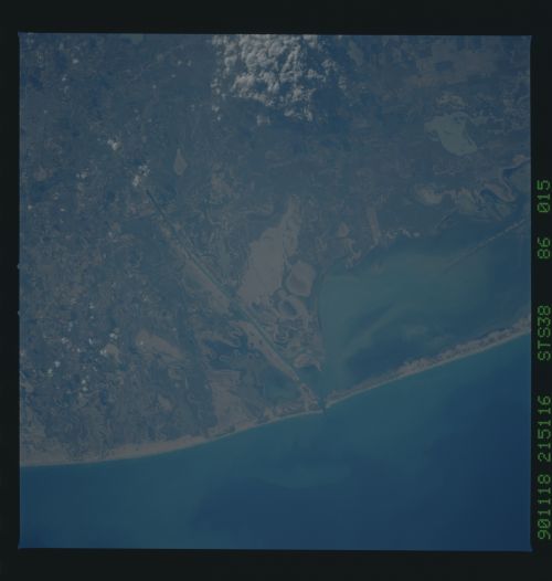
No GeoTIFF is available for this photo.Image Caption: STS038-86-15 South Coastal Texas, U.S.A. November 1990
Several features are identifiable in this photograph of the southern tip of coastal Texas--the southern end of South Padre Island; the southern end of Laguna Madre; the southern terminus of the Intracoastal Waterway; and the Brownsville Ship Channel. The coast adjacent to the Gulf of Mexico consists generally of a mixture of light sandy soils and rich brown soils that overlay the clays and sands of the Rio Grande floodplain. The mottled appearance of the landscape, showing an assortment of tidal flats, swampy areas, and sandy terrain, makes it impossible to discriminate where the Rio Grande "flows" through this broad delta. The sediment pattern in Laguna Madre and a portion of the dredged Intracoastal Waterway (left center) indicate that sandy soils are transported by air and water throughout the coastal region of South Padre Island. Only a single runway of the airport east of Brownsville is discernible (right bottom corner).
Several features are identifiable in this photograph of the southern tip of coastal Texas--the southern end of South Padre Island; the southern end of Laguna Madre; the southern terminus of the Intracoastal Waterway; and the Brownsville Ship Channel. The coast adjacent to the Gulf of Mexico consists generally of a mixture of light sandy soils and rich brown soils that overlay the clays and sands of the Rio Grande floodplain. The mottled appearance of the landscape, showing an assortment of tidal flats, swampy areas, and sandy terrain, makes it impossible to discriminate where the Rio Grande "flows" through this broad delta. The sediment pattern in Laguna Madre and a portion of the dredged Intracoastal Waterway (left center) indicate that sandy soils are transported by air and water throughout the coastal region of South Padre Island. Only a single runway of the airport east of Brownsville is discernible (right bottom corner).
