< STS082-741-13 >
| NASA Photo ID | STS082-741-13 |
| Focal Length | 50mm |
| Date taken | 1997.02.20 |
| Time taken | 05:29:47 GMT |

Cloud masks available for this image:
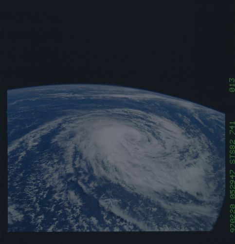
Spacecraft nadir point: 23.9° S, 66.0° E
Photo center point:
Photo center point by machine learning:
Photo center point:
Photo center point by machine learning:
Nadir to Photo Center:
Spacecraft Altitude: 334 nautical miles (619km)
Country or Geographic Name: | INDIAN OCEAN |
Features: | CYCLONE |
| Features Found Using Machine Learning: | |
Cloud Cover Percentage: | 60 (51-75)% |
Sun Elevation Angle: | 54° |
Sun Azimuth: | 75° |
Camera: | Hasselblad |
Focal Length: | 50mm |
Camera Tilt: | Low Oblique |
Format: | 5069: Kodak Elite 100S, E6 Reversal, Replaces Lumiere, Warmer in tone vs. Lumiere |
Film Exposure: | Under Exposed |
| Additional Information | |
| Width | Height | Annotated | Cropped | Purpose | Links |
|---|---|---|---|---|---|
| 5700 pixels | 5900 pixels | No | No | Download Image | |
| 483 pixels | 500 pixels | No | No | Download Image |
Download Packaged File
Download a Google Earth KML for this Image
View photo footprint information
No GeoTIFF is available for this photo.Image Caption: Tropical Cyclone Karlette in the south central Indian Ocean on its way to Madagascar. 714-055 was taken on 20 Feb 97 at 034611 GMT from nadir 14.5S 66.3E. 741-013 was taken on 20 Feb 97 at 052947 GMT from nadir 23.8S 65.3E.
