< STS043-151-106 >
| NASA Photo ID | STS043-151-106 |
| Focal Length | 90mm |
| Date taken | 1991.08.09 |
| Time taken | 13:24:29 GMT |
Resolutions offered for this image:
640 x 480 pixels
640 x 480 pixels
Cloud masks available for this image:
Spacecraft nadir point: 23.9° N, 76.4° W
Photo center point: 24.0° N, 77.0° W
Photo center point by machine learning:
Photo center point: 24.0° N, 77.0° W
Photo center point by machine learning:
Nadir to Photo Center: West
Spacecraft Altitude: 176 nautical miles (326km)
Country or Geographic Name: | BAHAMAS |
Features: | ANDROS, TONGUE OF OCEAN |
| Features Found Using Machine Learning: | |
Cloud Cover Percentage: | 20 (11-25)% |
Sun Elevation Angle: | 36° |
Sun Azimuth: | 87° |
Camera: | Linhof |
Focal Length: | 90mm |
Camera Tilt: | 12 degrees |
Format: | QX868: Kodak, natural color positive, Ektachrome QX868(5017 emulsion), ASA 64, thin base |
Film Exposure: | Normal |
| Additional Information | |
| Width | Height | Annotated | Cropped | Purpose | Links |
|---|---|---|---|---|---|
| 640 pixels | 480 pixels | No | No | ISD 1 | Download Image |
Download Packaged File
Download a Google Earth KML for this Image
View photo footprint information
No GeoTIFF is available for this photo.Image Caption:
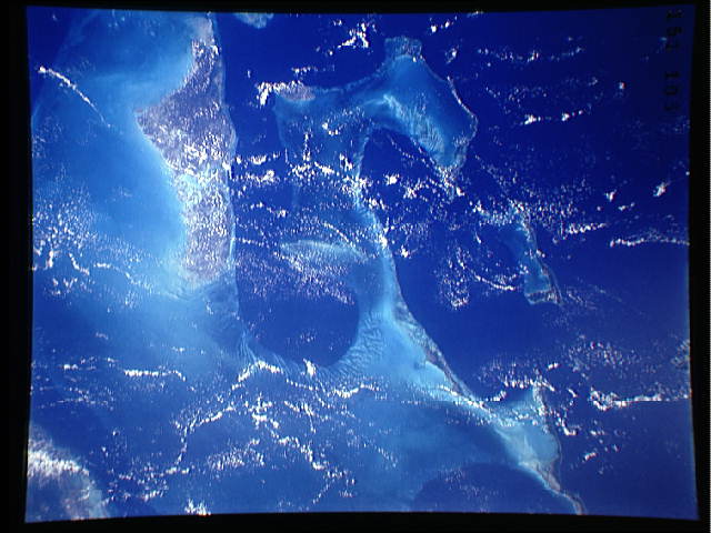
S43-151-106 - Bahamas, Tongue of the Ocean
This striking photograph of the Bahama Banks shows the complex
bottom topography of the area. The majority of the Banks has less
than 3 meters of water (light blue and light green colors); the
Tongue of the Ocean (deep blue colors) has water more than 2000
meter s deep. Andros Island is the largest island in the photo-
graph. Linhof camera, 90mm lens.
This photo shows the complex bottom topography of the Bahama Banks area(24.0N, 77.0W). The majority of the feature (light blue color), where the tide and current sculpted bottom detail may be seen, is shallow water, generally less than three meters deep. However, the Tongue of the Ocean, Deep blue color, is water over 2,000 meters in depth. Andros Island is the largest island in the photograph. _
