Geographic Region: IRAN
Feature: NAMAK SALT WASTE
|
Geographic Region: IRAN Feature: NAMAK SALT WASTE |
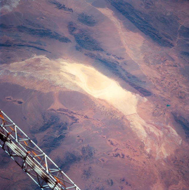 |
| STS091-704-092 Namak Desert, Iran June 1998 Located in northeast Iran, the Namak Desert includes the extensive, highly reflective salt waste or dry lake (center image). Runoff from very limited precipitation that occurs in this arid region drains toward the dry lake. A westerly draining stream valley (light-colored linear feature) extends towards the top center as the intermittently flowing stream heads towards the Great Salt Desert (not in this view). The darker looking, generally elongated features are mountain ranges that enclose many of the arid valleys in northeastern Iran. Elevation differences or local relief between the valley floors and mountain peaks or ridgelines vary from less than 1000 feet (305 meters) to well over 3000 feet (914 meters). Large quantities of eroded materials (uniform-looking color) have formed piedmont alluvial plains around the base of the mountains. The object in the lower left corner of the image is part of the Space Shuttle. |
| Images: | All Available Images Low-Resolution 106k |
|
| Mission: | STS091 |
|
| Roll - Frame: | 704 - 92 |
|
| Geographical Name: | IRAN |
|
| Features: | NAMAK SALT WASTE |
|
| Center Lat x Lon: | 34.5N x 58.0E |
|
| Film Exposure: | N | N=Normal exposure, U=Under exposed, O=Over exposed, F=out of Focus |
| Percentage of Cloud Cover-CLDP: | 0 |
|
| Camera:: | HB |
|
| Camera Tilt: | 44 | LO=Low Oblique, HO=High Oblique, NV=Near Vertical |
| Camera Focal Length: | 250 |
|
| Nadir to Photo Center Direction: | W | The direction from the nadir to the center point, N=North, S=South, E=East, W=West |
| Stereo?: | Y | Y=Yes there is an adjacent picture of the same area, N=No there isn't |
| Orbit Number: | 57 |
|
| Date: | 19980606 | YYYYMMDD |
| Time: | 114418 | GMT HHMMSS |
| Nadir Lat: | 33.1N |
Latitude of suborbital point of spacecraft |
| Nadir Lon: | 60.9E |
Longitude of suborbital point of spacecraft |
| Sun Azimuth: | 274 | Clockwise angle in degrees from north to the sun measured at the nadir point |
| Space Craft Altitude: | 198 | nautical miles |
| Sun Elevation: | 39 | Angle in degrees between the horizon and the sun, measured at the nadir point |
| Land Views: | DESERT, MOUNTAIN |
|
| Water Views: | PLAYA |
|
| Atmosphere Views: | |
|
| Man Made Views: | |
|
| City Views: | |
|
Photo is not associated with any sequences | ||
| NASA Home Page |
JSC Home Page |
JSC Digital Image Collection |
Earth Science & Remote Sensing |
|
This service is provided by the International Space Station program and the JSC Earth Science & Remote Sensing Unit, ARES Division, Exploration Integration Science Directorate.

|