STS61A-50-57
| NASA Photo ID | STS61A-50-57 |
| Focal Length | 250mm |
| Date taken | 1985.11.01 |
| Time taken | 20:36:07 GMT |
Resolutions offered for this image:
3913 x 3936 pixels 636 x 639 pixels 5700 x 5900 pixels 500 x 518 pixels 640 x 480 pixels
3913 x 3936 pixels 636 x 639 pixels 5700 x 5900 pixels 500 x 518 pixels 640 x 480 pixels

Cloud masks available for this image:
Spacecraft nadir point: 16.0° N, 155.0° W
Photo center point: 19.5° N, 155.5° W
Photo center point by machine learning:
Photo center point: 19.5° N, 155.5° W
Photo center point by machine learning:
Nadir to Photo Center: North
Spacecraft Altitude: 176 nautical miles (326km)
Country or Geographic Name: | USA-HAWAII |
Features: | HAWAII |
| Features Found Using Machine Learning: | |
Cloud Cover Percentage: | 40 (26-50)% |
Sun Elevation Angle: | 52° |
Sun Azimuth: | 143° |
Camera: | Hasselblad |
Focal Length: | 250mm |
Camera Tilt: | 50 degrees |
Format: | 5017: Kodak, natural color positive, Ektachrome, X Professional, ASA 64, standard base |
Film Exposure: | Normal |
| Additional Information | |
| Width | Height | Annotated | Cropped | Purpose | Links |
|---|---|---|---|---|---|
| 3913 pixels | 3936 pixels | No | No | Earth From Space collection | Download Image |
| 636 pixels | 639 pixels | No | No | Earth From Space collection | Download Image |
| 5700 pixels | 5900 pixels | No | No | Download Image | |
| 500 pixels | 518 pixels | No | No | Download Image | |
| 640 pixels | 480 pixels | No | No | Download Image |
Download Packaged File
Download a Google Earth KML for this Image
View photo footprint information
Download a GeoTIFF for this photo
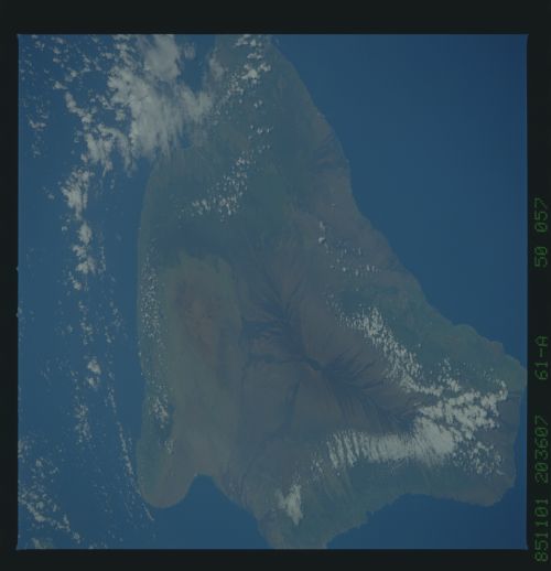
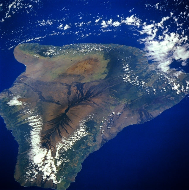
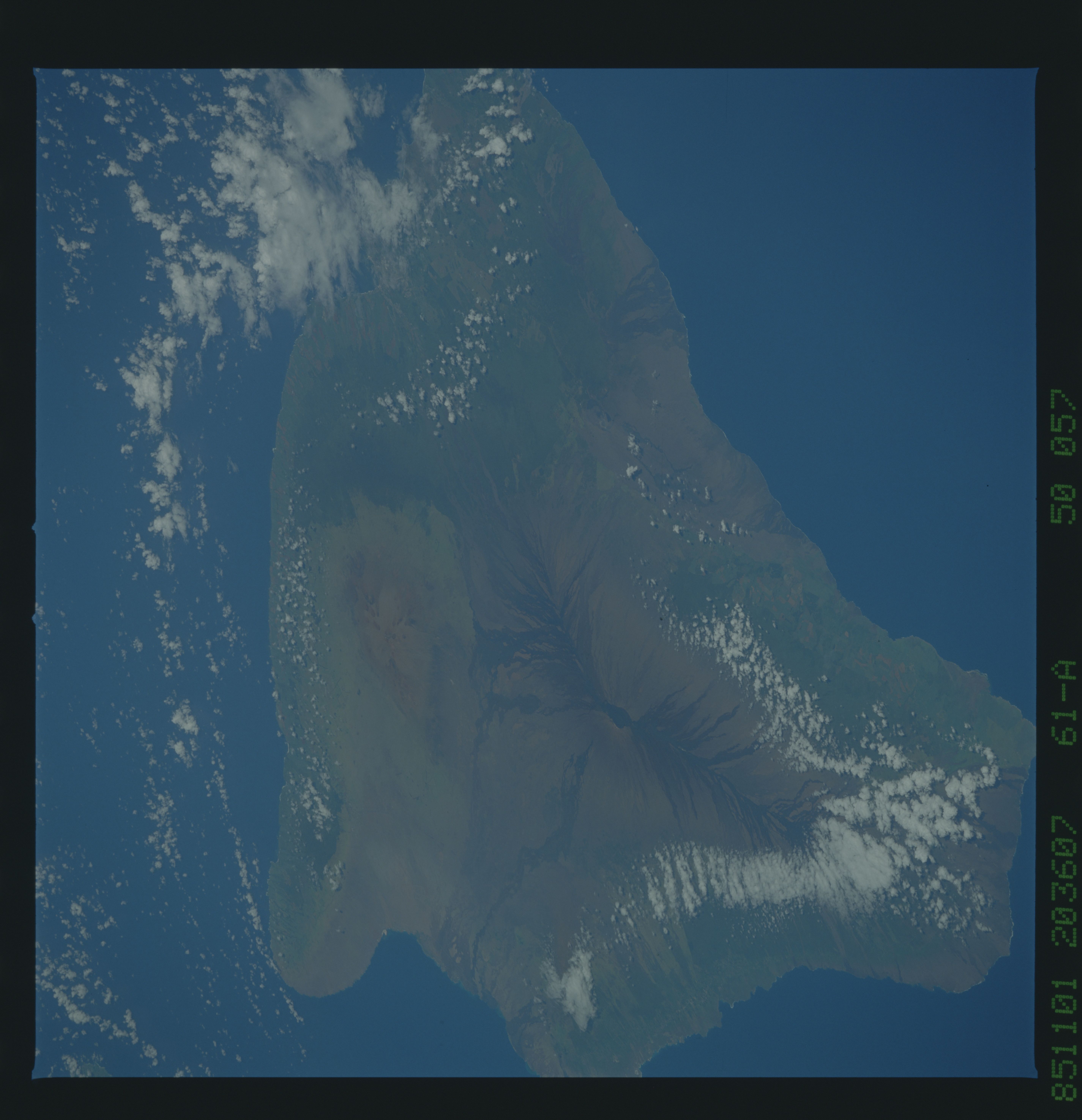
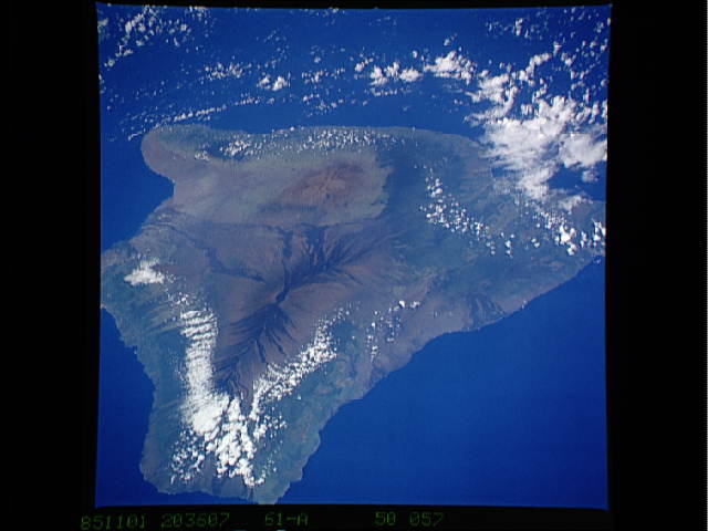
Image Caption: STS61A-050-0057 Hawaii, Hawaii, U.S.A. November 1985
Hawaii, the archipelago's youngest and largest island, is featured in this low-oblique, north-looking photograph. Apparent are the three main volcanoes that have created the big island--Mauna Loa [13 679 feet (4169 meters)], the easiest to recognize with its rift zone and dark, riblike basalt lava flows that radiate outward from the higher elevations; brownish-looking Mauna Kea, slightly taller at 13 796 feet (4205 meters), but lacking the dramatic appearance of Mauna Loa; and Kilauea near the south-eastern coast. The multiple craters of Kilauea [4078 feet (1243 meters)] are not easily discernible in this photograph. Kilauea and Mauna Loa continue to be two of the world's most active shield volcanoes as they periodically add new acreage to the big island.
Hawaii, the archipelago's youngest and largest island, is featured in this low-oblique, north-looking photograph. Apparent are the three main volcanoes that have created the big island--Mauna Loa [13 679 feet (4169 meters)], the easiest to recognize with its rift zone and dark, riblike basalt lava flows that radiate outward from the higher elevations; brownish-looking Mauna Kea, slightly taller at 13 796 feet (4205 meters), but lacking the dramatic appearance of Mauna Loa; and Kilauea near the south-eastern coast. The multiple craters of Kilauea [4078 feet (1243 meters)] are not easily discernible in this photograph. Kilauea and Mauna Loa continue to be two of the world's most active shield volcanoes as they periodically add new acreage to the big island.
