STS111-E-5485

| NASA Photo ID | STS111-E-5485 |
| Focal Length | 400mm |
| Date taken | 2002.06.17 |
| Time taken | GMT |
Resolutions offered for this image:
1024 x 768 pixels 540 x 405 pixels 540 x 359 pixels 1000 x 681 pixels 3032 x 2064 pixels 639 x 435 pixels
1024 x 768 pixels 540 x 405 pixels 540 x 359 pixels 1000 x 681 pixels 3032 x 2064 pixels 639 x 435 pixels


Cloud masks available for this image:
Spacecraft nadir point:
Photo center point: 41.0° N, 53.0° E
Photo center point by machine learning:
Photo center point: 41.0° N, 53.0° E
Photo center point by machine learning:
Nadir to Photo Center:
Spacecraft Altitude: nautical miles (0km)
Country or Geographic Name: | TURKMENISTAN |
Features: | KARA-BOGAZ-GOL, CHANNEL, SUNGLINT |
| Features Found Using Machine Learning: | |
Cloud Cover Percentage: | 10 (1-10)% |
Sun Elevation Angle: | ° |
Sun Azimuth: | ° |
Camera: | Kodak DCS760c Electronic Still Camera |
Focal Length: | 400mm |
Camera Tilt: | High Oblique |
Format: | 3060E: 3060 x 2036 pixel CCD, RGBG array |
Film Exposure: | |
| Additional Information | |
| Width | Height | Annotated | Cropped | Purpose | Links |
|---|---|---|---|---|---|
| 1024 pixels | 768 pixels | Photographic Highlights | Download Image | ||
| 540 pixels | 405 pixels | Photographic Highlights | Download Image | ||
| 540 pixels | 359 pixels | Yes | Yes | Earth From Space collection | Download Image |
| 1000 pixels | 681 pixels | No | No | NASA's Earth Observatory web site | Download Image |
| 3032 pixels | 2064 pixels | No | No | Download Image | |
| 639 pixels | 435 pixels | No | No | Download Image |
Download Packaged File
Download a Google Earth KML for this Image
View photo footprint information
Download a GeoTIFF for this photo
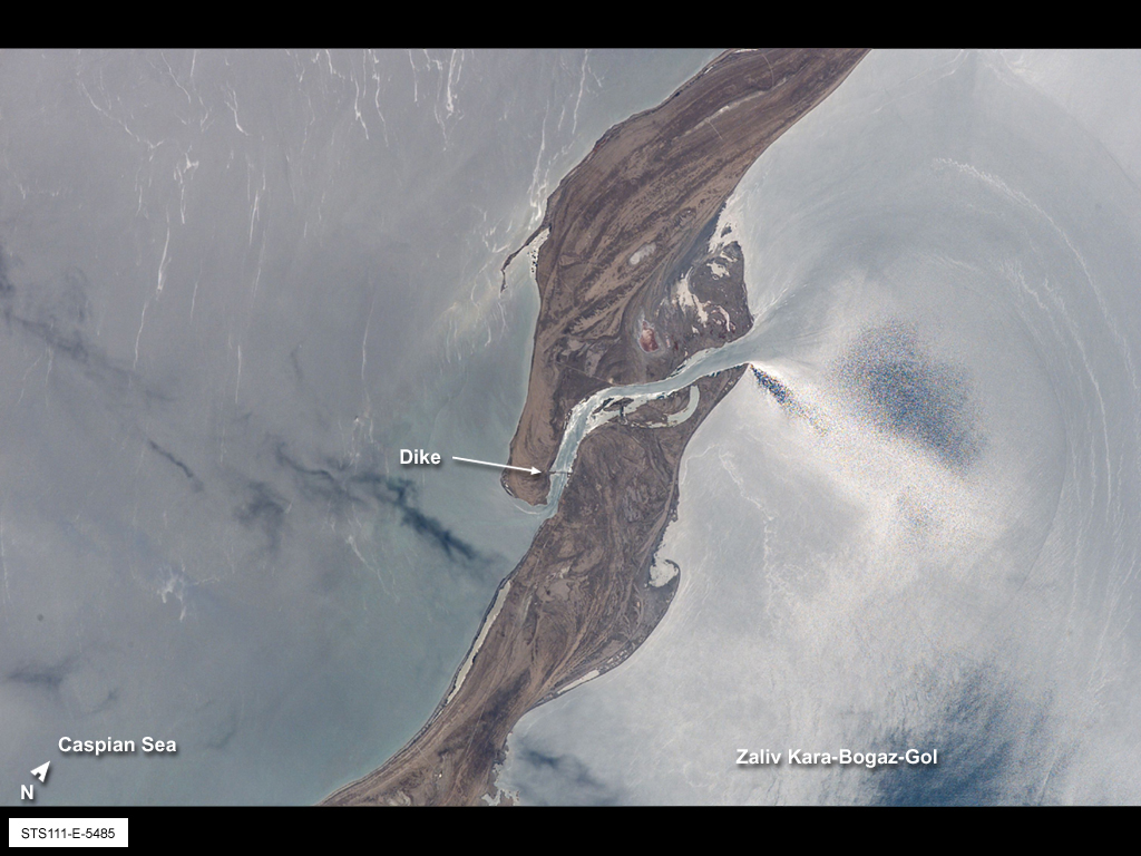
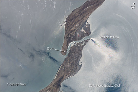
Image Caption: The large eastern embayment of the Caspian Sea, the Zaliv Kara-Bogaz-Gol, provides astronauts the chance to observe several oceanographic phenomena. This view taken by the STS-111 crew from the Space Shuttle in June 2002 shows the sun reflecting off the surface waters that surround the spit that defines the Zaliv Kara-Bogaz-Gol from the open Caspian Sea. The sunglint reveals the flow of fresher water through the spit channel and into the bay. Old shorelines and accretionary features can be seen on the spit, as well as the dam that was constructed in 1980 to stop the flow into the lower Kara-Bogaz-Gol basin.
The Caspian Sea has experienced dramatic changes in water levels throughout the past 100 years. From the 1930s until 1978, the water levels in the Caspian had dropped nearly 3 m. In 1980, in response to the rapidly dropping sea level, a dam was constructed to prevent water from flowing into the shallow and restricted Kara-Bogaz-Gol basin, resulting in the drying up of the bay. The dam was partially opened a few years later, and completely opened in 1992 when Caspian water levels started to rise quickly. Today, sea levels are more than 2.6 m higher than the 1978 levels, and, as shown here, water flows freely into the salty waters of the Zaliv Kara-Bogaz-Gol. Astronauts have also been documenting the coastlines around the Caspian Sea that have been impacted by the large sea level fluctuations.
The Caspian Sea has experienced dramatic changes in water levels throughout the past 100 years. From the 1930s until 1978, the water levels in the Caspian had dropped nearly 3 m. In 1980, in response to the rapidly dropping sea level, a dam was constructed to prevent water from flowing into the shallow and restricted Kara-Bogaz-Gol basin, resulting in the drying up of the bay. The dam was partially opened a few years later, and completely opened in 1992 when Caspian water levels started to rise quickly. Today, sea levels are more than 2.6 m higher than the 1978 levels, and, as shown here, water flows freely into the salty waters of the Zaliv Kara-Bogaz-Gol. Astronauts have also been documenting the coastlines around the Caspian Sea that have been impacted by the large sea level fluctuations.
