STS038-86-105
| NASA Photo ID | STS038-86-105 |
| Focal Length | 250mm |
| Date taken | 1990.11.19 |
| Time taken | 04:55:52 GMT |
Resolutions offered for this image:
5700 x 6000 pixels 500 x 526 pixels 640 x 480 pixels 1634 x 1542 pixels 2674 x 2761 pixels 909 x 1181 pixels 4880 x 4800 pixels 540 x 702 pixels
5700 x 6000 pixels 500 x 526 pixels 640 x 480 pixels 1634 x 1542 pixels 2674 x 2761 pixels 909 x 1181 pixels 4880 x 4800 pixels 540 x 702 pixels


Cloud masks available for this image:
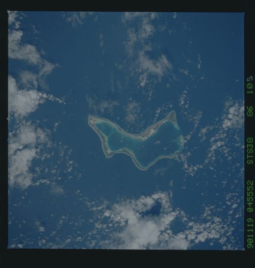
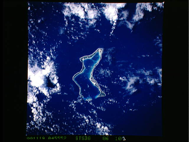
Spacecraft nadir point: 7.9° S, 72.6° E
Photo center point: 7.5° S, 72.5° E
Photo center point by machine learning:
Photo center point: 7.5° S, 72.5° E
Photo center point by machine learning:
Nadir to Photo Center: North
Spacecraft Altitude: 130 nautical miles (241km)
Country or Geographic Name: | CHAGOS ARCHIPELAGO |
Features: | DIEGO GARCIA |
| Features Found Using Machine Learning: | |
Cloud Cover Percentage: | 45 (26-50)% |
Sun Elevation Angle: | 59° |
Sun Azimuth: | 115° |
Camera: | Hasselblad |
Focal Length: | 250mm |
Camera Tilt: | 11 degrees |
Format: | 5017: Kodak, natural color positive, Ektachrome, X Professional, ASA 64, standard base |
Film Exposure: | Normal |
| Additional Information | |
| Width | Height | Annotated | Cropped | Purpose | Links |
|---|---|---|---|---|---|
| 5700 pixels | 6000 pixels | No | No | Download Image | |
| 500 pixels | 526 pixels | No | No | Download Image | |
| 640 pixels | 480 pixels | No | No | Download Image | |
| 1634 pixels | 1542 pixels | No | Yes | ReefBase 1 | Download Image |
| 2674 pixels | 2761 pixels | No | ReefBase 1 | Download Image | |
| 909 pixels | 1181 pixels | Yes | Yes | Publisher Request | Download Image |
| 4880 pixels | 4800 pixels | No | No | Download Image | |
| 540 pixels | 702 pixels | Yes | Yes | Publisher Request | Download Image |
Download Packaged File
Download a Google Earth KML for this Image
View photo footprint information
Download a GeoTIFF for this photo
Image Caption: The southernmost atoll of Diego Garcia includes a major US military base. This atoll is also notable for the narrow but clearly continuous island following the atoll rim [STS038-86-105, 1990].
