STS036-151-100
| NASA Photo ID | STS036-151-100 |
| Focal Length | 250mm |
| Date taken | 1990.03.02 |
| Time taken | 09:30:17 GMT |
Resolutions offered for this image:
788 x 978 pixels 619 x 768 pixels 435 x 540 pixels 4457 x 5643 pixels 505 x 640 pixels 640 x 480 pixels 1619 x 1944 pixels 4379 x 5662 pixels 656 x 800 pixels
788 x 978 pixels 619 x 768 pixels 435 x 540 pixels 4457 x 5643 pixels 505 x 640 pixels 640 x 480 pixels 1619 x 1944 pixels 4379 x 5662 pixels 656 x 800 pixels


Cloud masks available for this image:
Spacecraft nadir point: 31.0° N, 30.0° E
Photo center point: 31.0° N, 30.0° E
Photo center point by machine learning:
Photo center point: 31.0° N, 30.0° E
Photo center point by machine learning:
Nadir to Photo Center:
Spacecraft Altitude: 127 nautical miles (235km)
Country or Geographic Name: | EGYPT |
Features: | ALEXANDRIA, SEDIMENT |
| Features Found Using Machine Learning: | |
Cloud Cover Percentage: | 0 (no clouds present) |
Sun Elevation Angle: | 51° |
Sun Azimuth: | 164° |
Camera: | Linhof |
Focal Length: | 250mm |
Camera Tilt: | 0 degrees |
Format: | QX868: Kodak, natural color positive, Ektachrome QX868(5017 emulsion), ASA 64, thin base |
Film Exposure: | Normal |
| Additional Information | |
| Width | Height | Annotated | Cropped | Purpose | Links |
|---|---|---|---|---|---|
| 788 pixels | 978 pixels | No | No | Cities collection | Download Image |
| 619 pixels | 768 pixels | Photographic Highlights | Download Image | ||
| 435 pixels | 540 pixels | Photographic Highlights | Download Image | ||
| 4457 pixels | 5643 pixels | No | No | Earth From Space collection | Download Image |
| 505 pixels | 640 pixels | No | No | Earth From Space collection | Download Image |
| 640 pixels | 480 pixels | No | No | ISD 1 | Download Image |
| 1619 pixels | 1944 pixels | Download Image | |||
| 4379 pixels | 5662 pixels | No | No | Download Image | |
| 656 pixels | 800 pixels | Yes | No | Download Image |
Download Packaged File
Download a Google Earth KML for this Image
View photo footprint information
Download a GeoTIFF for this photo
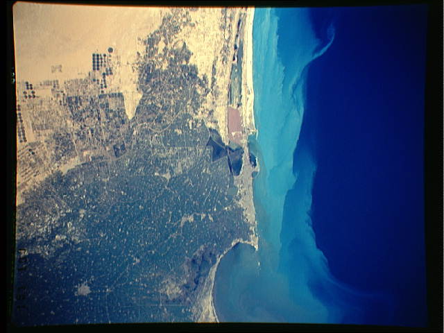
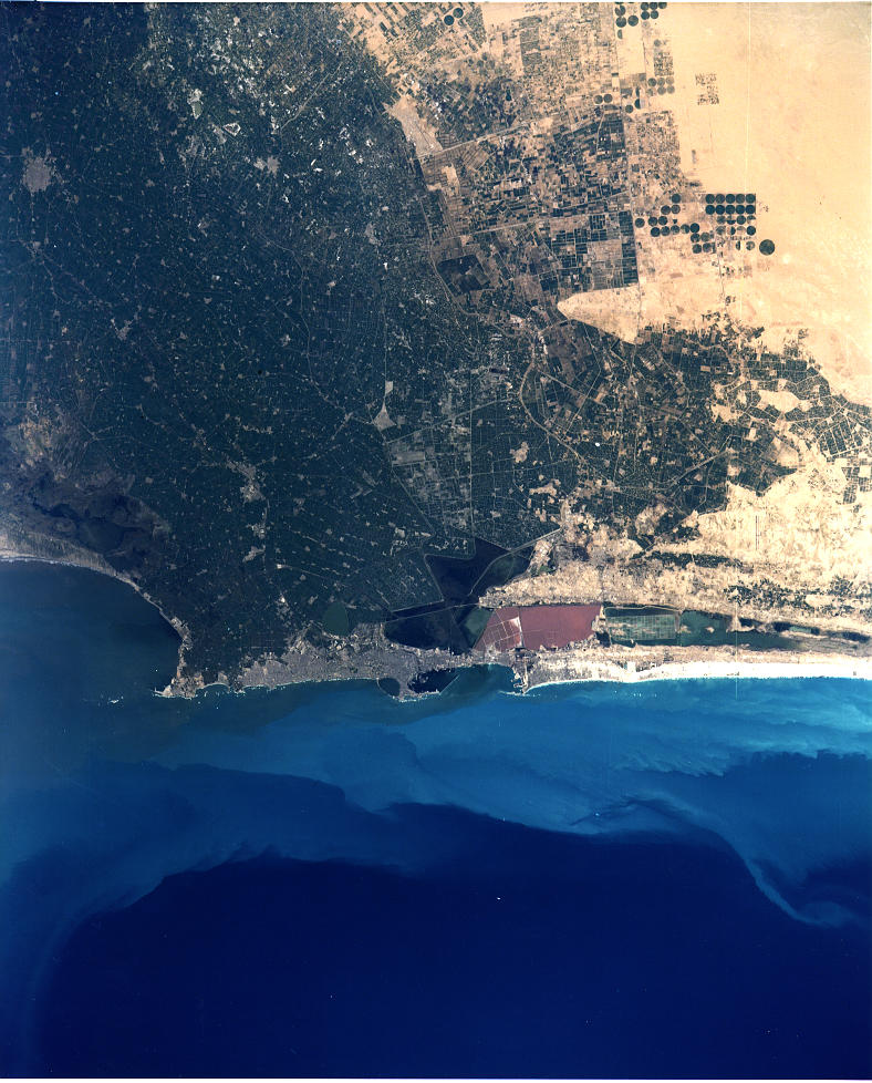
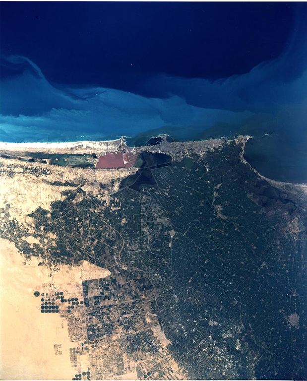
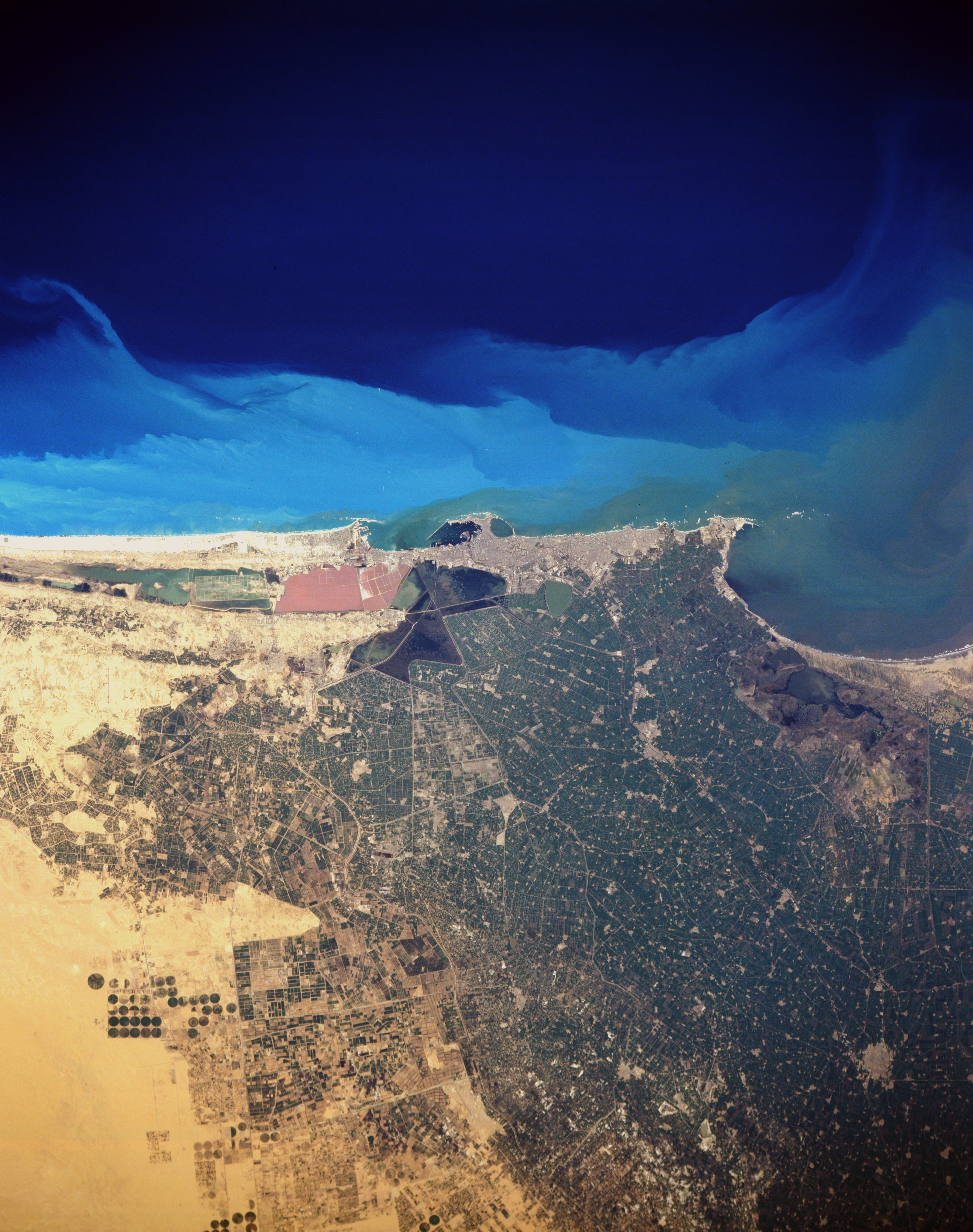
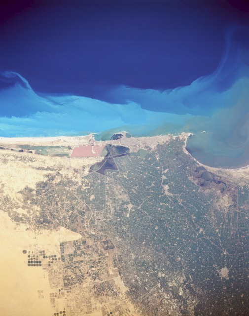
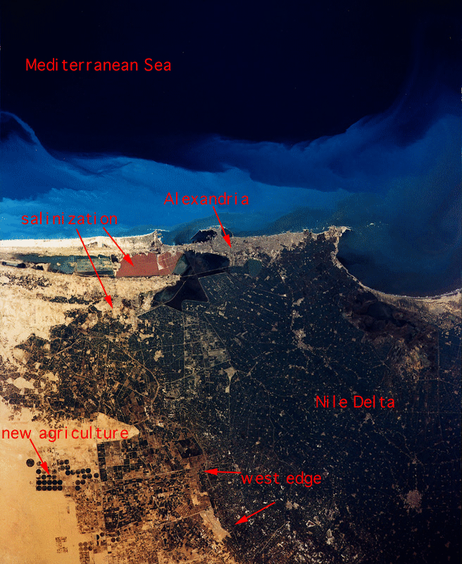
Image Caption: STS036-151-100 Alexandria, Egypt March 1990
The seaport city of Alexandria, with a population of more than 3.5 million, is built primarily on a sandy strip of land between the Mediterranean Sea and Lake Mareotis. An industrial and commercial city, Alexandria anchors the western extent of the large Nile River Delta. Although most of the city infrastructure is not visible, some of the large modern harbor facilities, including a breakwater structure, are discernible in the small bay. The unusual tan water body southwest of the port facilities is possibly a holding pond for industrial effluents. A narrow band of darker substance in the water current appears to be flowing toward the east, and farther offshore, an interesting light blue turbidity indicates water color boundaries along this part of the Mediterranean Sea. A series of canals and roadways appears within the darker green of the fertile, intensively cultivated and irrigated, agricultural Nile River Delta. Circular field patterns southwest of the city indicate that center-pivot irrigation is being used in addition to irrigation from ditches and canals. The smaller, highly reflective areas scattered among the irrigated farmland are villages and cities.
The seaport city of Alexandria, with a population of more than 3.5 million, is built primarily on a sandy strip of land between the Mediterranean Sea and Lake Mareotis. An industrial and commercial city, Alexandria anchors the western extent of the large Nile River Delta. Although most of the city infrastructure is not visible, some of the large modern harbor facilities, including a breakwater structure, are discernible in the small bay. The unusual tan water body southwest of the port facilities is possibly a holding pond for industrial effluents. A narrow band of darker substance in the water current appears to be flowing toward the east, and farther offshore, an interesting light blue turbidity indicates water color boundaries along this part of the Mediterranean Sea. A series of canals and roadways appears within the darker green of the fertile, intensively cultivated and irrigated, agricultural Nile River Delta. Circular field patterns southwest of the city indicate that center-pivot irrigation is being used in addition to irrigation from ditches and canals. The smaller, highly reflective areas scattered among the irrigated farmland are villages and cities.
