STS002-11-141
| NASA Photo ID | STS002-11-141 |
| Focal Length | 100mm |
| Date taken | 1981.11.__ |
| Time taken | GMT |


Cloud masks available for this image:
Spacecraft nadir point:
Photo center point: 30.5° N, 58.5° E
Photo center point by machine learning:
Photo center point: 30.5° N, 58.5° E
Photo center point by machine learning:
Nadir to Photo Center:
Spacecraft Altitude: nautical miles (0km)
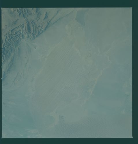
Country or Geographic Name: | IRAN |
Features: | LUT DESERT |
| Features Found Using Machine Learning: | |
Cloud Cover Percentage: | 0 (no clouds present) |
Sun Elevation Angle: | ° |
Sun Azimuth: | ° |
Camera: | Hasselblad |
Focal Length: | 100mm |
Camera Tilt: | Near Vertical |
Format: | QX824: Kodak Ektachrome 64 |
Film Exposure: | Normal |
| Additional Information | |
| Width | Height | Annotated | Cropped | Purpose | Links |
|---|---|---|---|---|---|
| 4393 pixels | 4600 pixels | No | No | Download Image | |
| 478 pixels | 500 pixels | No | No | Download Image | |
| 640 pixels | 480 pixels | No | No | Download Image |
Download Packaged File
Download a Google Earth KML for this Image
View photo footprint information
Download a GeoTIFF for this photo
Image Caption: Iran is a large country with several desert regions. In the Dasht-E-Lut (Lut Desert) (30.5N, 58.5E) an area known as Namak-Zar, about 100 miles east of the city of Kerman, is at the center of this photograph. Some of the world's most prominent Yardangs (very long, parallel ridges and depressions) have been wind eroded in these desert dry lake bed sediments. At the left of the photo is a large field of sand dunes at right angles to the wind.
