ISS040-E-018725
| NASA Photo ID | ISS040-E-018725 |
| Focal Length | 38mm |
| Date taken | 2014.06.24 |
| Time taken | 16:47:15 GMT |

Cloud masks available for this image:
Spacecraft nadir point: 27.8° N, 77.7° W
Photo center point:
Photo center point by machine learning:
Photo center point:
Photo center point by machine learning:
Nadir to Photo Center:
Spacecraft Altitude: 222 nautical miles (411km)
Country or Geographic Name: | |
Features: | |
| Features Found Using Machine Learning: | |
Cloud Cover Percentage: | 19 (11-25)% |
Sun Elevation Angle: | 83° |
Sun Azimuth: | 124° |
Camera: | NIKON D3S S/N: 2007931 |
Focal Length: | 38mm |
Camera Tilt: | |
Format: | |
Film Exposure: | |
| Additional Information | |
| Width | Height | Annotated | Cropped | Purpose | Links |
|---|---|---|---|---|---|
| 4256 pixels | 2832 pixels | No | No | Download Image | |
| 640 pixels | 426 pixels | No | No | Download Image |
Download Packaged File
Download a Google Earth KML for this Image
View photo footprint information
Download a GeoTIFF for this photo
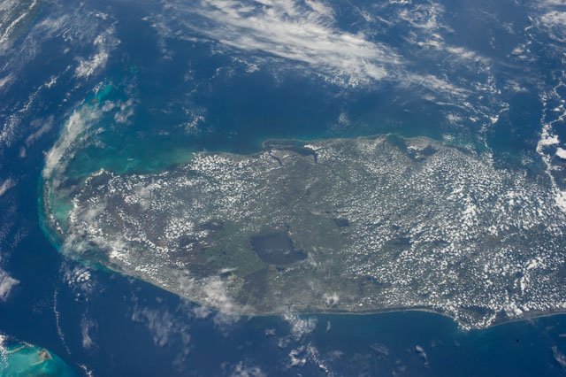
Image Caption: ISS040-E-018725 (24 June 2014) --- One of the Expedition 40 crew members aboard the Earth-orbiting International Space Station photographed this image featuring most of the peninsular portion of the state of Florida. Lake Okeechobee stands out in the south central part of the state. The heavily-populated area of Miami can be traced along the Atlantic Coast near the bottom of the scene. Cape Canaveral and the Kennedy Space Center are in lower right portion of the image on the Atlantic Coast. The Florida Keys are at the south (left) portion of the scene and the Gulf Coast, including the Tampa-St. Petersburg area, is near frame center.
