ISS040-E-006163
| NASA Photo ID | ISS040-E-006163 |
| Focal Length | 200mm |
| Date taken | 2014.05.31 |
| Time taken | 22:56:26 GMT |

Cloud masks available for this image:
Spacecraft nadir point: 44.1° S, 176.3° E
Photo center point: 39.3° S, 174.3° E
Photo center point by machine learning:
Photo center point: 39.3° S, 174.3° E
Photo center point by machine learning:
Nadir to Photo Center: North
Spacecraft Altitude: 228 nautical miles (422km)
Country or Geographic Name: | NEW ZEALAND-NI |
Features: | PUBLIC INPUTS (from public image detectives, not NASA): MOUNT TARANAKI,NEW ZEALAND,NORTH ISLAND,O.,VOL. |
| Features Found Using Machine Learning: | |
Cloud Cover Percentage: | 10 (1-10)% |
Sun Elevation Angle: | 22° |
Sun Azimuth: | 19° |
Camera: | Nikon D3S Electronic Still Camera |
Focal Length: | 200mm |
Camera Tilt: | 54 degrees |
Format: | 4256E: 4256 x 2832 pixel CMOS sensor, 36.0mm x 23.9mm, total pixels: 12.87 million, Nikon FX format |
Film Exposure: | |
| Additional Information | |
| Width | Height | Annotated | Cropped | Purpose | Links |
|---|---|---|---|---|---|
| 4256 pixels | 2832 pixels | No | No | Download Image | |
| 640 pixels | 426 pixels | No | No | Download Image |
Download Packaged File
Download a Google Earth KML for this Image
View photo footprint information
Download a GeoTIFF for this photo
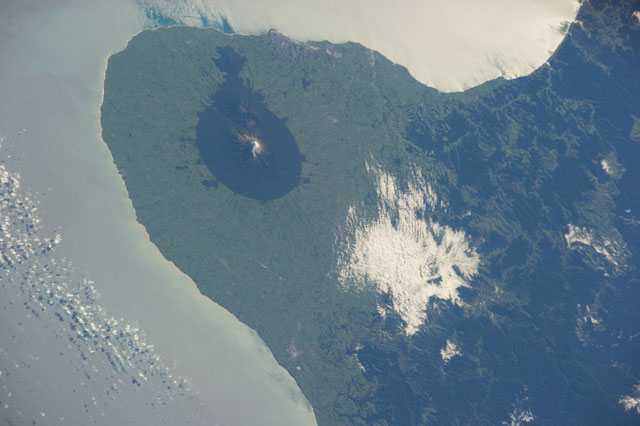
Image Caption: ISS040-E-006163 (31 May 2014) --- One of the Expedition 40 crew members aboard the International Space Station recorded this nearly vertical image of the Taranaki region on the west coast of New Zealand's North Island on May 31, 2014. Just above left center in the frame is Mount Egmont, an 8,261-ft. high (2,518 meters) volcano which last erupted in 1860, according to NASA scientists studying the space station imagery.
