ISS039-E-019482
| NASA Photo ID | ISS039-E-019482 |
| Focal Length | 400mm |
| Date taken | 2014.05.09 |
| Time taken | 07:11:27 GMT |
Resolutions offered for this image:
1000 x 706 pixels 540 x 381 pixels 1440 x 960 pixels 720 x 480 pixels 4256 x 2832 pixels 640 x 426 pixels
1000 x 706 pixels 540 x 381 pixels 1440 x 960 pixels 720 x 480 pixels 4256 x 2832 pixels 640 x 426 pixels

Cloud masks available for this image:
Spacecraft nadir point: 46.1° N, 12.2° E
Photo center point: 45.4° N, 12.3° E
Photo center point by machine learning:
Photo center point: 45.4° N, 12.3° E
Photo center point by machine learning:
Nadir to Photo Center: South
Spacecraft Altitude: 222 nautical miles (411km)
Country or Geographic Name: | ITALY |
Features: | VENICE LAGOON, VENICE, SEDIMENT PLUMES |
| Features Found Using Machine Learning: | |
Cloud Cover Percentage: | 10 (1-10)% |
Sun Elevation Angle: | 34° |
Sun Azimuth: | 100° |
Camera: | Nikon D3S Electronic Still Camera |
Focal Length: | 400mm |
Camera Tilt: | 11 degrees |
Format: | 4256E: 4256 x 2832 pixel CMOS sensor, 36.0mm x 23.9mm, total pixels: 12.87 million, Nikon FX format |
Film Exposure: | |
| Additional Information | |
| Width | Height | Annotated | Cropped | Purpose | Links |
|---|---|---|---|---|---|
| 1000 pixels | 706 pixels | No | Yes | Earth From Space collection | Download Image |
| 540 pixels | 381 pixels | Yes | Yes | Earth From Space collection | Download Image |
| 1440 pixels | 960 pixels | No | No | NASA's Earth Observatory web site | Download Image |
| 720 pixels | 480 pixels | Yes | Yes | NASA's Earth Observatory web site | Download Image |
| 4256 pixels | 2832 pixels | No | No | Download Image | |
| 640 pixels | 426 pixels | No | No | Download Image |
Download Packaged File
Download a Google Earth KML for this Image
View photo footprint information
Download a GeoTIFF for this photo
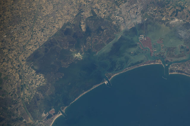
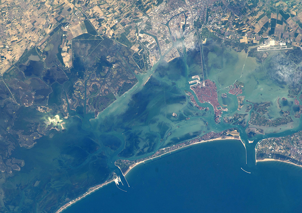
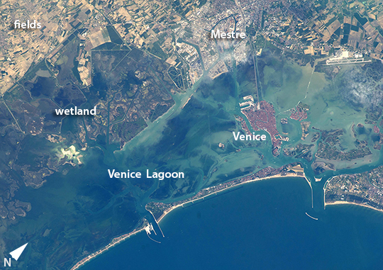
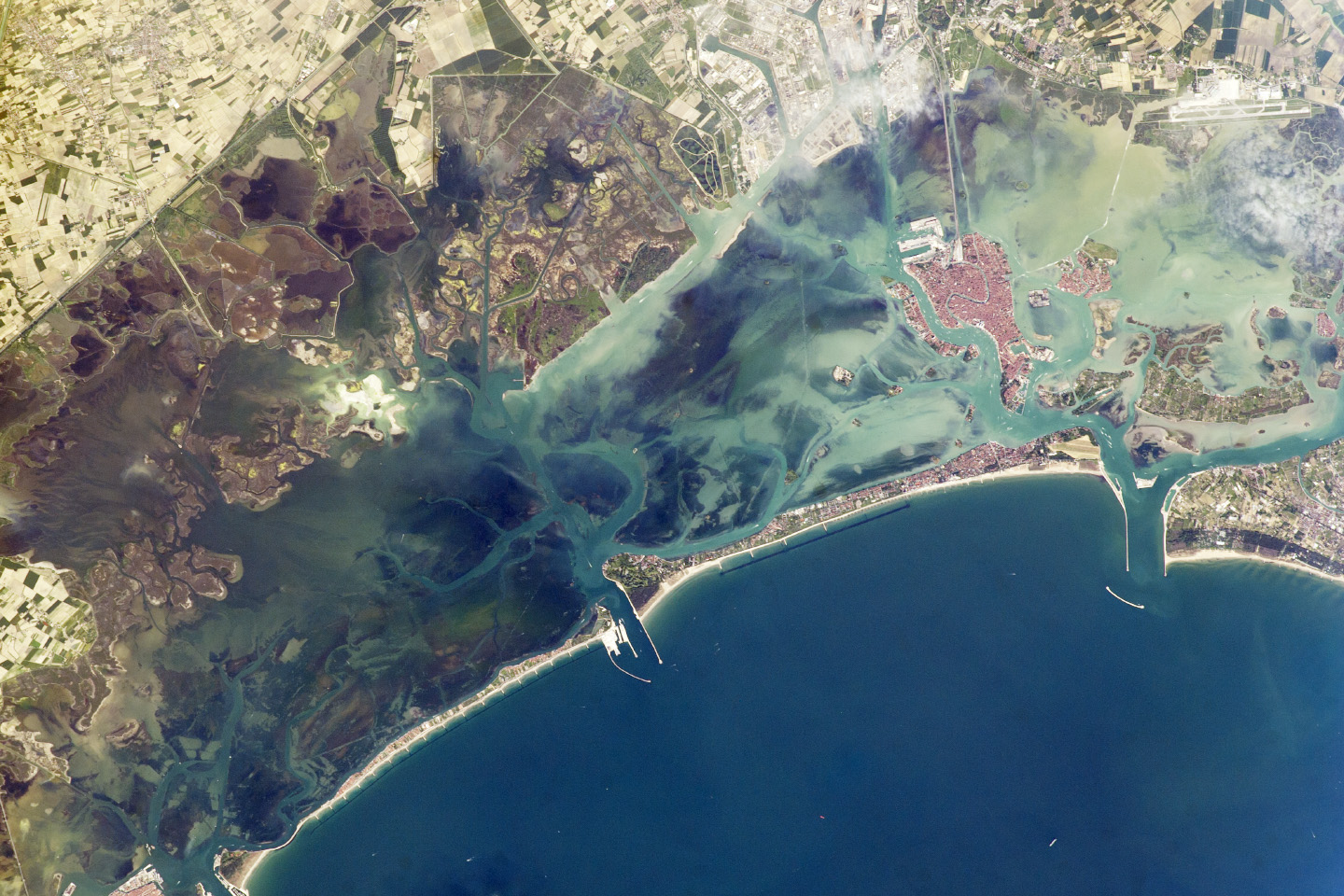
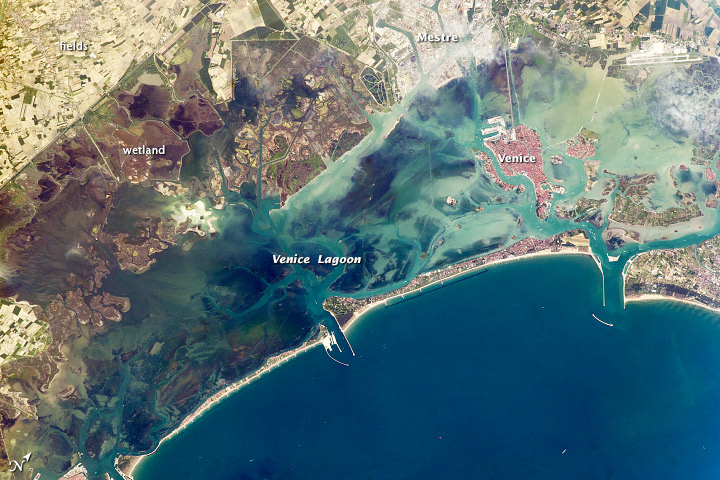
Image Caption: Venice Lagoon, Italy
A narrow barrier island protects the Lagoon of Venice from storm waves in the northern Adriatic Sea, and breakwaters protect inlets to the lagoon. Red tiles of the roofs on the island of Venice contrast with the grays of the mainland sister city of Mestre. The cities are joined by a prominent causeway. Another causeway joins the island to the airport (image top right). Small bright agricultural fields of well drained soils (top left) contrast with the darker vegetation of backbay swamps where fishing is a popular pastime.
Dense urban populations on its shores and heavy use by craft of all kinds result in turbid water in the northern half of the lagoon. This and other topics of environmental concern led to the creation of the Atlas of the Lagoon (Atlante della laguna) by the City of Venice and other regional partners in 2002 in order to document environmental conditions and track changes. Today, the Atlante della laguna is available online, and provides a comprehensive data collection of interpretive maps and imagery for the Lagoon of Venice - including astronaut photographs from the International Space Station.
