ISS038-E-57806
| NASA Photo ID | ISS038-E-57806 |
| Focal Length | 1000mm |
| Date taken | 2014.02.21 |
| Time taken | 19:01:00 GMT |
Resolutions offered for this image:
1000 x 667 pixels 540 x 360 pixels 1440 x 960 pixels 720 x 480 pixels 6048 x 4032 pixels 640 x 427 pixels
1000 x 667 pixels 540 x 360 pixels 1440 x 960 pixels 720 x 480 pixels 6048 x 4032 pixels 640 x 427 pixels

Spacecraft nadir point: 30.0° N, 98.3° W
Photo center point: 27.9° N, 97.1° W
Photo center point by machine learning:
Photo center point: 27.9° N, 97.1° W
Photo center point by machine learning:
Nadir to Photo Center: Southeast
Spacecraft Altitude: 223 nautical miles (413km)
Country or Geographic Name: | USA-TEXAS |
Features: | INTRACOASTAL WATERWAY, PORT ARANSAS |
| Features Found Using Machine Learning: | |
Cloud Cover Percentage: | 10 (1-10)% |
Sun Elevation Angle: | 50° |
Sun Azimuth: | 185° |
Camera: | Nikon D3X Electronic Still Camera |
Focal Length: | 1000mm |
Camera Tilt: | 33 degrees |
Format: | 6048E: 6048 x 4032 pixel CMOS sensor, 35.9mm x 24.0mm, total pixels: 25.72 million, Nikon FX format |
Film Exposure: | |
| Additional Information | |
| Width | Height | Annotated | Cropped | Purpose | Links |
|---|---|---|---|---|---|
| 1000 pixels | 667 pixels | No | No | Earth From Space collection | Download Image |
| 540 pixels | 360 pixels | Yes | No | Earth From Space collection | Download Image |
| 1440 pixels | 960 pixels | No | No | Download Image | |
| 720 pixels | 480 pixels | Yes | No | NASA's Earth Observatory web site | Download Image |
| 6048 pixels | 4032 pixels | No | No | Download Image | |
| 640 pixels | 427 pixels | No | No | Download Image |
Download Packaged File
Download a Google Earth KML for this Image
View photo footprint information
Download a GeoTIFF for this photo
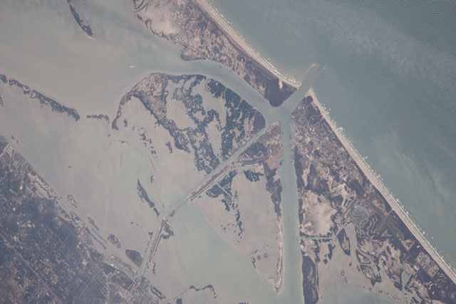
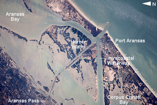
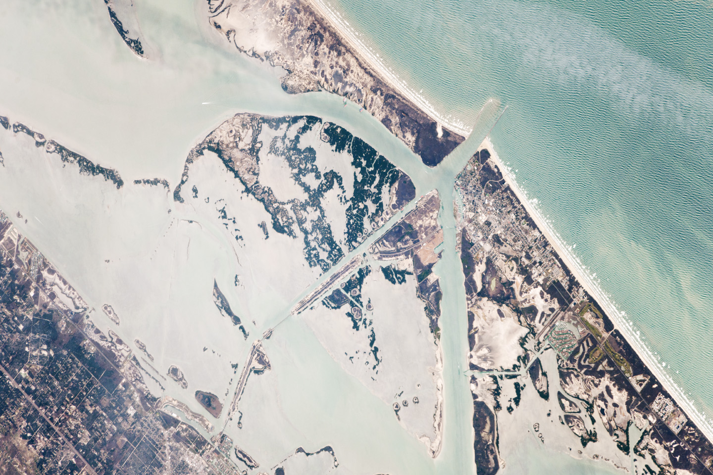
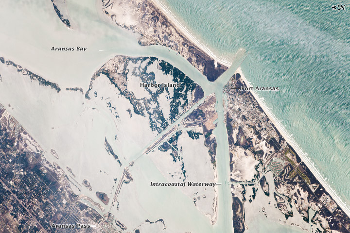
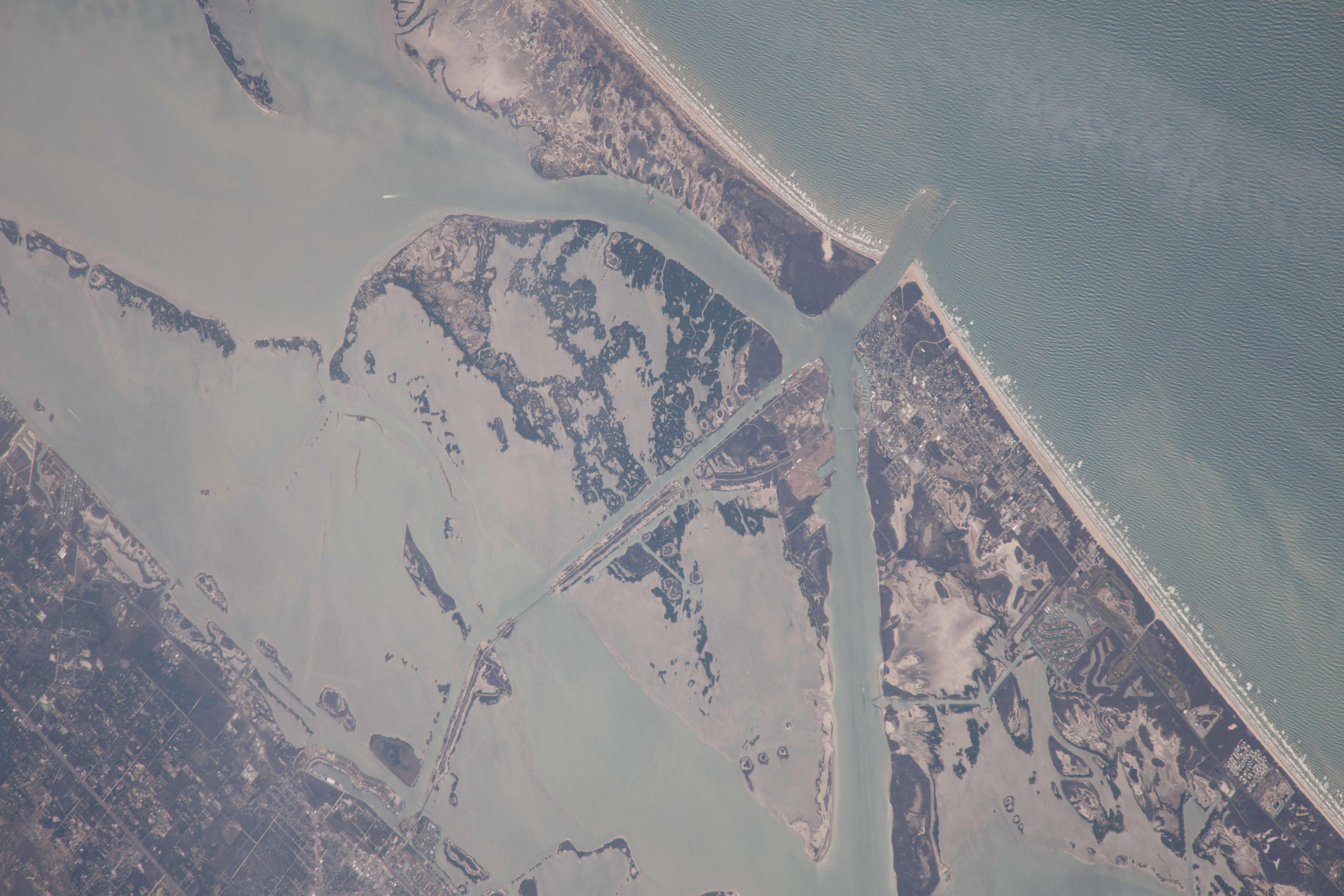
Image Caption: Port Aransas and the Intracoastal Waterway, Texas
This image from the International Space Station shows 18 km (11.2 mi) of Intracoastal Waterway, the 4800 km-long (3000 mi) barge channel that lies on the protected inshore of the coastal islands of the southern and eastern USA, including coastal Texas. The small city of Port Aransas lies on a barrier island fully 18 km (11.2 mi) seaward of the mainland and its sister city, Aransas Pass (image lower left). This image shows parts of the waterway that are artificial, as in the straight sector leading into Corpus Christi Bay. (Corpus Christi lies outside the lower margin of the image.) Other sectors of the waterway are natural bays such as Aransas Bay.
Jetties protect the inlet into the Gulf of Mexico (image top right). Inlets at many points cut through the barrier islands to give shipping access to the Gulf of Mexico and the Atlantic Ocean. Several large rivers allow access from the waterway to distant inland ports, as in the cases of the Mississippi and Hudson Rivers. A recent study concluded that barge shipment in the Gulf Coast sector of the waterway remains the least-cost alternative for many commodities, with petroleum and petroleum products amounting to 30% of the total tonnage.
