ISS038-E-057977
| NASA Photo ID | ISS038-E-057977 |
| Focal Length | 1000mm |
| Date taken | 2014.02.22 |
| Time taken | 19:52:59 GMT |
Resolutions offered for this image:
1000 x 667 pixels 540 x 360 pixels 1440 x 960 pixels 720 x 480 pixels 6048 x 4032 pixels 640 x 427 pixels
1000 x 667 pixels 540 x 360 pixels 1440 x 960 pixels 720 x 480 pixels 6048 x 4032 pixels 640 x 427 pixels


Cloud masks available for this image:
Spacecraft nadir point: 46.4° N, 88.8° W
Photo center point: 45.3° N, 86.7° W
Photo center point by machine learning:
Photo center point: 45.3° N, 86.7° W
Photo center point by machine learning:
Nadir to Photo Center: Southeast
Spacecraft Altitude: 221 nautical miles (409km)
Country or Geographic Name: | USA-WISCONSIN |
Features: | WASHINGTON ISLAND, ICE |
| Features Found Using Machine Learning: | |
Cloud Cover Percentage: | 10 (1-10)% |
Sun Elevation Angle: | 29° |
Sun Azimuth: | 210° |
Camera: | Nikon D3X Electronic Still Camera |
Focal Length: | 1000mm |
Camera Tilt: | 33 degrees |
Format: | 6048E: 6048 x 4032 pixel CMOS sensor, 35.9mm x 24.0mm, total pixels: 25.72 million, Nikon FX format |
Film Exposure: | |
| Additional Information | |
| Width | Height | Annotated | Cropped | Purpose | Links |
|---|---|---|---|---|---|
| 1000 pixels | 667 pixels | No | No | Earth From Space collection | Download Image |
| 540 pixels | 360 pixels | Yes | No | Earth From Space collection | Download Image |
| 1440 pixels | 960 pixels | No | No | NASA's Earth Observatory web site | Download Image |
| 720 pixels | 480 pixels | Yes | No | NASA's Earth Observatory web site | Download Image |
| 6048 pixels | 4032 pixels | No | No | Download Image | |
| 640 pixels | 427 pixels | No | No | Download Image |
Download Packaged File
Download a Google Earth KML for this Image
View photo footprint information
Download a GeoTIFF for this photo
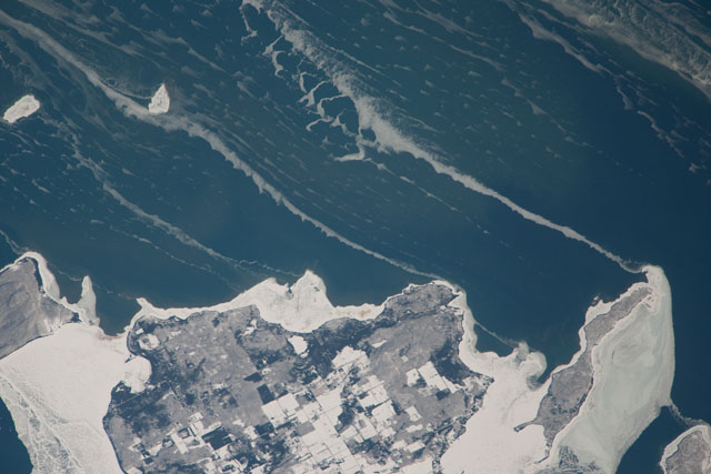
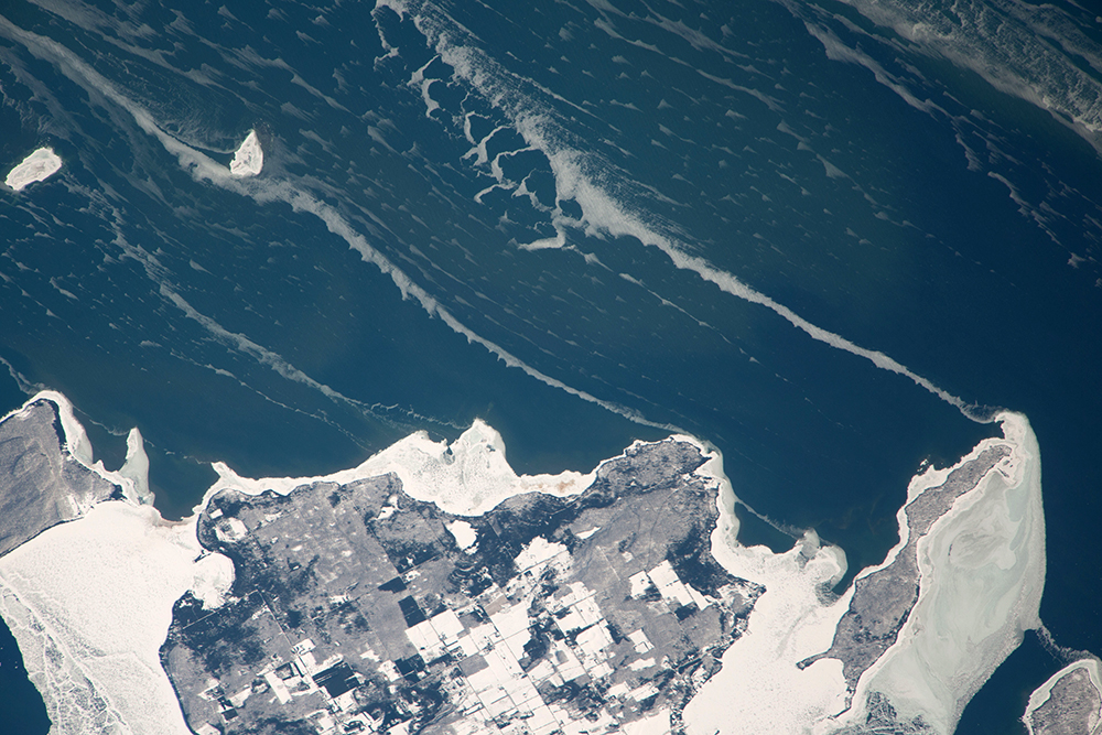
Image Caption: Snow-covered fields appear as geometric patterns on Lake Michigan's Washington Island in this photograph taken by the crew of the International Space Station. The island is 9 km long (5.6 miles) and lies on Lake Michigan's western shore, as a continuation of Wisconsin's Door Peninsula. (Note that north is to the lower left in the image.)
White coastal ice hugs the shoreline and connects Washington Island with Detroit Island and Rock Island. Ice typically accumulates first near land, where cooling is more rapid than in deeper lake water. Two other snow-covered islands (image top left) are small enough and far enough from land to evade the collars of ice.
On the day this image was taken, southwesterly winds were blowing ice into the lake in the form of long, coherent stringers. The thickness of a stringer is related to the length of coastline that feeds it. The smallest northern stringer (image left) is fed by the shortest section of upwind coastline, and the longest (image right) is supplied by the large amount of shore ice around Detroit Island. These dominant winds keep a narrow zone (along the western shore of the lake) clear of ice, even as accumulations in the winter of 2014 reach the highest levels ever recorded in Lake Michigan.
