ISS038-E-035123
| NASA Photo ID | ISS038-E-035123 |
| Focal Length | 1000mm |
| Date taken | 2014.01.21 |
| Time taken | 16:15:05 GMT |
Resolutions offered for this image:
1000 x 671 pixels 540 x 362 pixels 1440 x 960 pixels 720 x 480 pixels 6048 x 4032 pixels 640 x 427 pixels
1000 x 671 pixels 540 x 362 pixels 1440 x 960 pixels 720 x 480 pixels 6048 x 4032 pixels 640 x 427 pixels


Cloud masks available for this image:
Spacecraft nadir point: 10.1° N, 86.9° W
Photo center point: 12.2° N, 86.3° W
Photo center point by machine learning:
Photo center point: 12.2° N, 86.3° W
Photo center point by machine learning:
Nadir to Photo Center: North
Spacecraft Altitude: 225 nautical miles (417km)
Country or Geographic Name: | NICARAGUA |
Features: | APOYEQUE VOLCANO, CHILTEPE PENINSULA, XILOA LAKE, LAKE MANAGUA |
| Features Found Using Machine Learning: | |
Cloud Cover Percentage: | 10 (1-10)% |
Sun Elevation Angle: | 51° |
Sun Azimuth: | 139° |
Camera: | Nikon D3X Electronic Still Camera |
Focal Length: | 1000mm |
Camera Tilt: | 30 degrees |
Format: | 6048E: 6048 x 4032 pixel CMOS sensor, 35.9mm x 24.0mm, total pixels: 25.72 million, Nikon FX format |
Film Exposure: | |
| Additional Information | |
| Width | Height | Annotated | Cropped | Purpose | Links |
|---|---|---|---|---|---|
| 1000 pixels | 671 pixels | No | Yes | Earth From Space collection | Download Image |
| 540 pixels | 362 pixels | Yes | Yes | Earth From Space collection | Download Image |
| 1440 pixels | 960 pixels | No | No | NASA's Earth Observatory web site | Download Image |
| 720 pixels | 480 pixels | Yes | Yes | NASA's Earth Observatory web site | Download Image |
| 6048 pixels | 4032 pixels | No | No | Download Image | |
| 640 pixels | 427 pixels | No | No | Download Image |
Download Packaged File
Download a Google Earth KML for this Image
View photo footprint information
Download a GeoTIFF for this photo
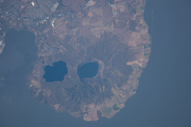
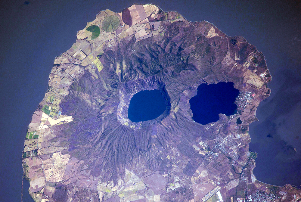
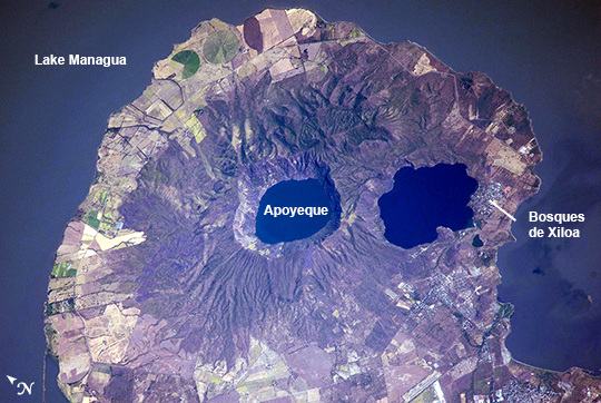
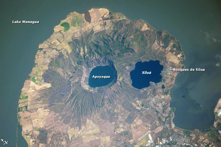
Image Caption: Apoyeque Volcano, Nicaragua
Note: This caption refers to the image versions labeled "NASA's Earth Observatory web site".
The Chiltepe Peninsula, highlighted in this astronaut photograph from the International Space Station, extends into Lake Managua in west-central Nicaragua. The peninsula is formed from part of a large ignimbrite shield, a geologic structure created by deposition of primarily low density materials (such as pumice) ejected during violent, explosive eruptive activity. Ignimbrite deposits are most commonly emplaced during large pyroclastic flows - gravity-driven mixtures of rock, ash, and volcanic gases that can cover 100s of kilometers at speeds of 100s of kilometers per hour - with ignimbrite shields formed over geologic time by successive flows.
The Apoyeque caldera, filled with a 2.8 km wide and 400 meter deep lake, dominates the center of the peninsula. Geological evidence indicates that Apoyeque last erupted around 50 BCE (plus or minus 100 years). The Laguna Xiloa maar - a volcanic crater formed by the explosive interaction of magma and groundwater - is located immediately to the southeast of Apoyeque and is also filled with a lake. Laguna Xiloa last erupted approximately 6100 years ago.
More recently, a swarm of small earthquakes was detected near Apoyeque in 2012. These seismic swarms, when detected in volcanically active areas, may indicate movement of magma prior to an eruption. The capital city of Managua, not visible in the image, is located approximately 15 kilometers to the southeast of Apoyeque, while the town of Bosques de Xiloa is considerably closer (approximately 4 km).
