ISS037-E-005104

| NASA Photo ID | ISS037-E-005104 |
| Focal Length | 300mm |
| Date taken | 2013.10.02 |
| Time taken | 17:46:52 GMT |
Resolutions offered for this image:
1000 x 580 pixels 540 x 313 pixels 720 x 480 pixels 4256 x 2832 pixels 640 x 426 pixels
1000 x 580 pixels 540 x 313 pixels 720 x 480 pixels 4256 x 2832 pixels 640 x 426 pixels

Cloud masks available for this image:
Spacecraft nadir point: 51.8° S, 74.1° W
Photo center point: 49.9° S, 73.3° W
Photo center point by machine learning:
Photo center point: 49.9° S, 73.3° W
Photo center point by machine learning:
Nadir to Photo Center: North
Spacecraft Altitude: 228 nautical miles (422km)
Country or Geographic Name: | ARGENTINA |
Features: | SOUTHERN PATAGONIA ICEFIELD, UPSALA GL. |
| Features Found Using Machine Learning: | |
Cloud Cover Percentage: | 10 (1-10)% |
Sun Elevation Angle: | 41° |
Sun Azimuth: | 340° |
Camera: | Nikon D3 Electronic Still Camera |
Focal Length: | 300mm |
Camera Tilt: | 29 degrees |
Format: | 4256E: 4256 x 2832 pixel CMOS sensor, 36.0mm x 23.9mm, total pixels: 12.87 million, Nikon FX format |
Film Exposure: | |
| Additional Information | |
| Width | Height | Annotated | Cropped | Purpose | Links |
|---|---|---|---|---|---|
| 1000 pixels | 580 pixels | No | Yes | Earth From Space collection | Download Image |
| 540 pixels | 313 pixels | Yes | Yes | Earth From Space collection | Download Image |
| 720 pixels | 480 pixels | Yes | Yes | NASA's Earth Observatory web site | Download Image |
| 4256 pixels | 2832 pixels | No | No | Download Image | |
| 640 pixels | 426 pixels | No | No | Download Image |
Download Packaged File
Download a Google Earth KML for this Image
View photo footprint information
Download a GeoTIFF for this photo
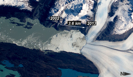
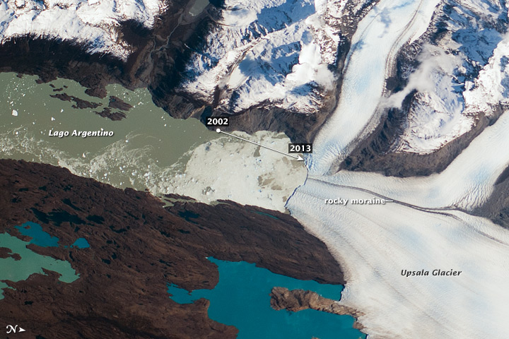
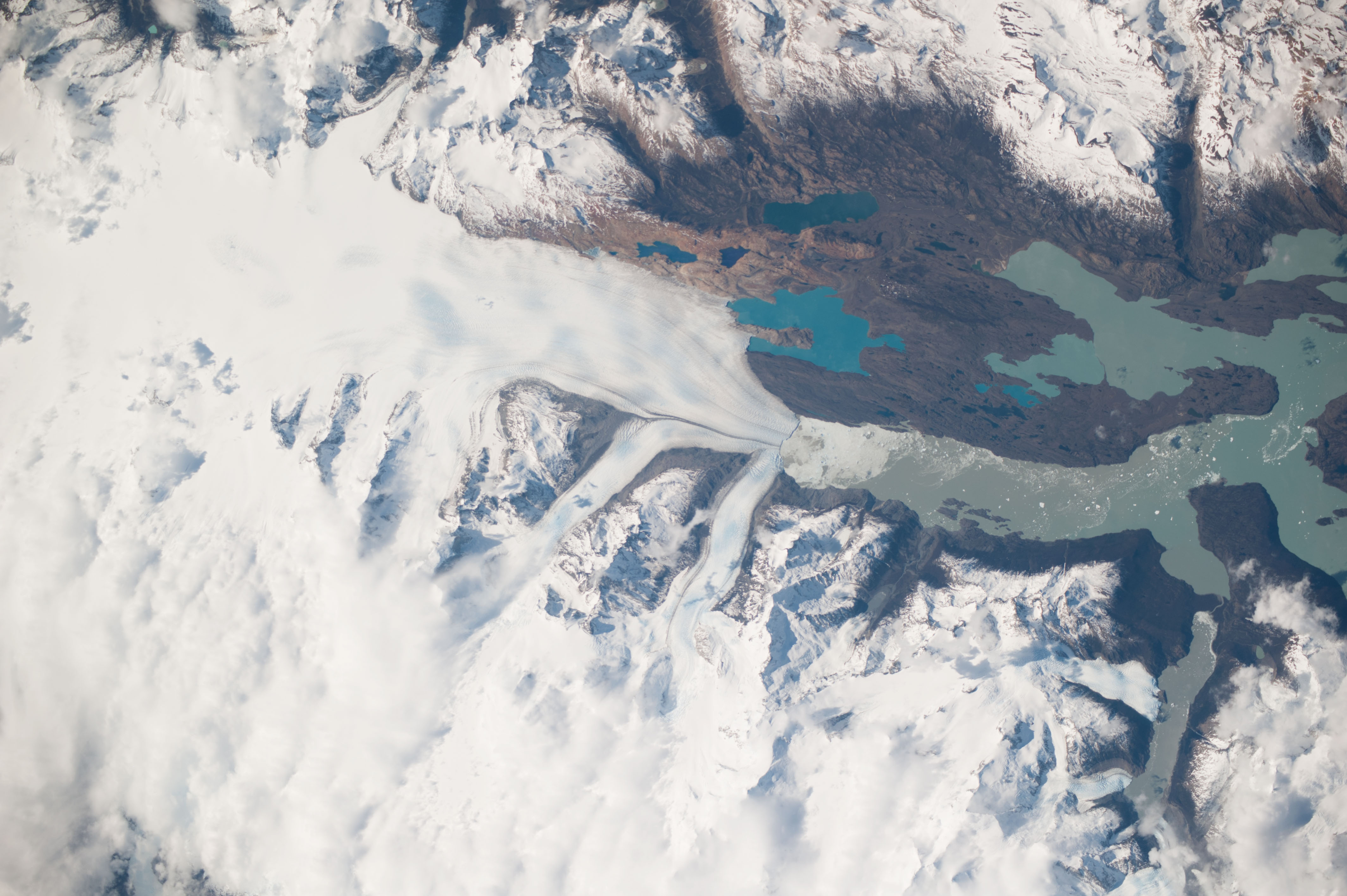
Image Caption: Upsala Glacier Retreat, Patagonia Icefield, 2002-2013
Note: This caption refers to the image versions labeled "NASA's Earth Observatory web site".
This astronaut photograph highlights the snout of the Upsala Glacier (49.88S 73.3W) on the Argentine side of the Southern Patagonian Icefield. Ice flow in this glacier (white mass, image right) is from the north (right). Dark lines of rocky moraine within the ice give a sense of the slow ice flow from right to left. A smaller side glacier joins Upsala at the present-day ice front--the wall from which masses of ice periodically collapse into Lake Argentino. In this image the 2.75 km-long wall casts a thin, dark shadow. The surface of Lake Argentino is whitened by a mass of ice debris from a recent collapse of the ice wall. Larger icebergs that have calved appear as white dots on the lake surface at image left.
Remotely sensed data, including detailed astronaut images such as this, have recorded the position of the ice front over the years. Even though the ice actually flows slowly southward, comparison of this October 2013 image with older data (not shown) indicates that the ice wall of the glacier has moved backwards--upstream--an average of 3.6 km since early 2002. This so-called "retreat" is believed by scientists to indicate local climatic warming in this part of South America. The warming not only causes the ice front to retreat but more importantly, causes overall thinning of the glacier ice mass, as a study of 63 glaciers in Patagonia has shown is now a general trend (Rignot et al. 2003). Ice-front retreat is now known to be related to volumetric loss due to melting.
Water color is related to glacier flow. Lake Argentino receives most of the ice from the glacier and thus also receives most of the "rock flour" (rocks ground to white powder by the ice scraping against the rock floor of the valley) from underneath the glacier. Glacial flour turns the lake water a gray-green hue in this image. The darker blue of the smaller lakes (image bottom) indicates that they are receiving much less rock flour.
Rignot E, Rivera A, and Casassa G, 2003, Contribution of the Patagonia Icefields of South America to sea level rise. Science 302:434 - 437.
