ISS036-E-9405
| NASA Photo ID | ISS036-E-9405 |
| Focal Length | 50mm |
| Date taken | 2013.06.17 |
| Time taken | 06:20:43 GMT |
Resolutions offered for this image:
1000 x 598 pixels 540 x 323 pixels 1440 x 960 pixels 720 x 480 pixels 4256 x 2832 pixels 640 x 426 pixels
1000 x 598 pixels 540 x 323 pixels 1440 x 960 pixels 720 x 480 pixels 4256 x 2832 pixels 640 x 426 pixels


Cloud masks available for this image:
Spacecraft nadir point: 24.7° N, 94.1° W
Photo center point: 30.5° N, 96.5° W
Photo center point by machine learning:
Photo center point: 30.5° N, 96.5° W
Photo center point by machine learning:
Nadir to Photo Center: North
Spacecraft Altitude: 221 nautical miles (409km)
Country or Geographic Name: | USA-TEXAS |
Features: | HOUSTON AT NIGHT, AUSTIN AT NIGHT, SAN ANTONIO AT NIGHT, STORMS |
| Features Found Using Machine Learning: | |
Cloud Cover Percentage: | 0 (no clouds present) |
Sun Elevation Angle: | -42° |
Sun Azimuth: | 1° |
Camera: | Nikon D3S Electronic Still Camera |
Focal Length: | 50mm |
Camera Tilt: | High Oblique |
Format: | 4256E: 4256 x 2832 pixel CMOS sensor, 36.0mm x 23.9mm, total pixels: 12.87 million, Nikon FX format |
Film Exposure: | |
| Additional Information | |
| Width | Height | Annotated | Cropped | Purpose | Links |
|---|---|---|---|---|---|
| 1000 pixels | 598 pixels | No | Yes | Earth From Space collection | Download Image |
| 540 pixels | 323 pixels | Yes | Yes | Earth From Space collection | Download Image |
| 1440 pixels | 960 pixels | No | Yes | NASA's Earth Observatory web site | Download Image |
| 720 pixels | 480 pixels | Yes | Yes | NASA's Earth Observatory web site | Download Image |
| 4256 pixels | 2832 pixels | No | No | Download Image | |
| 640 pixels | 426 pixels | No | No | Download Image |
Download Packaged File
Download a Google Earth KML for this Image
View photo footprint information
Download a GeoTIFF for this photo
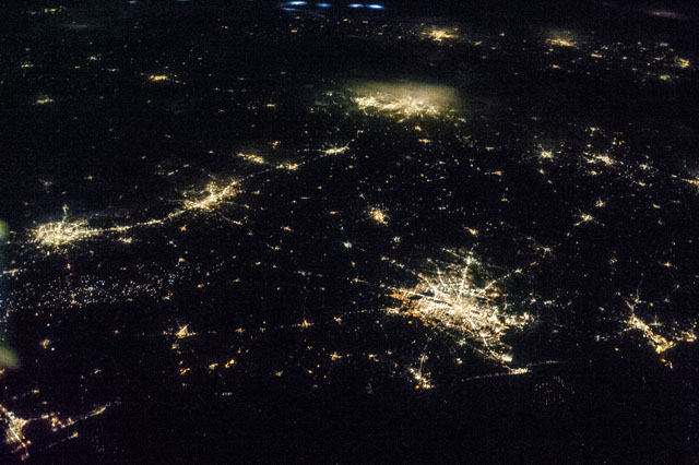
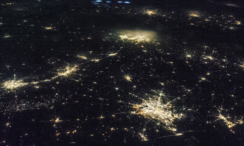
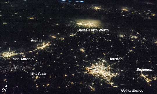
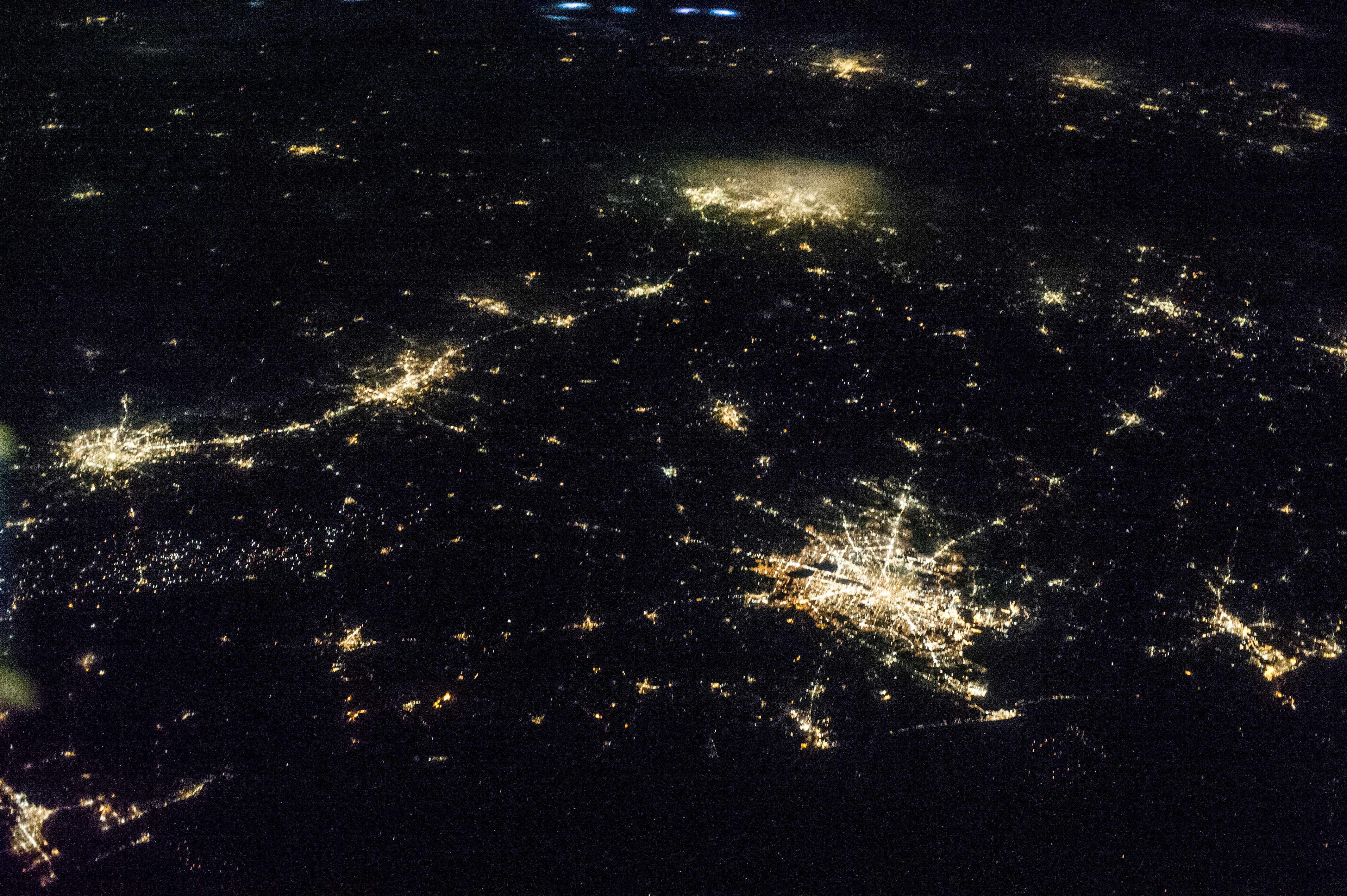
Image Caption: Texas Metropolitan Areas at Night
This striking astronaut photograph taken from the International Space Station (ISS) illustrates the four largest metropolitan areas of Texas (by population, using 2010 US Census estimates). The extent of the metropolitan areas is readily visible at night due to city and roadway lighting networks. The largest metro area, Dallas-Fort Worth-Arlington(population over 6.5 million) is visible at image top center; the lighting pattern appears less distinct due to local cloud cover. Four brightly illuminated cloud tops to the northwest (image top center) indicate thunderstorm activity over neighboring Oklahoma.
Coming in a close second with a population of approximately 6.1 million, the Houston-Sugar Land-Baytown metro area is located along the Gulf of Mexico coastline at image lower right. To the east near the border with Louisiana, the metropolitan area of Beaumont-Port Arthur ranks tenth (pop. near 400,000) within Texas.
Moving inland to south-central Texas, the San Antonio-New Braunfels metro area (image left) has the third largest population of over 2 million. A band of lighting visible to the southeast of San Antonio marks well pads associated with the Eagle Ford Formation (also known as the Eagle Ford Shale); this geologic formation is an important producer of both oil and natural gas.
The capital city of Texas (Austin) is included within the Austin-Round Rock-San Marcos metro area to the northeast of San Antonio; it ranks fourth in terms of population with over 1.7 million. The greater Austin metro area is located in central Texas between the Hill Country to the west and the coastal plain to the east-southeast.
This image was taken with a relatively high viewing angle from the ISS, as opposed to looking "straight down" towards the Earth's surface as is typical for most orbital remote sensing instruments. Oblique viewing angles tend to change the apparent distance between objects - for a sense of scale, the actual distance between the central Houston and Dallas-Fort Worth metro areas is approximately 367 kilometers (228 miles).
