ISS036-E-35632
| NASA Photo ID | ISS036-E-35632 |
| Focal Length | 50mm |
| Date taken | 2013.08.24 |
| Time taken | 18:33:34 GMT |

Spacecraft nadir point: 43.9° N, 73.9° W
Photo center point: 44.0° N, 77.5° W
Photo center point by machine learning:
Photo center point: 44.0° N, 77.5° W
Photo center point by machine learning:
Nadir to Photo Center: West
Spacecraft Altitude: 220 nautical miles (407km)
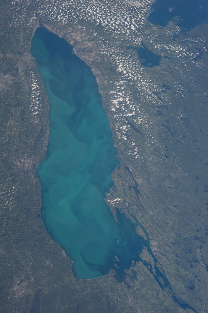
Country or Geographic Name: | CANADA-O |
Features: | L. ONTARIO, KINGSTON, SYRACUSE, ROCHESTER, TORONTO |
| Features Found Using Machine Learning: | |
Cloud Cover Percentage: | 10 (1-10)% |
Sun Elevation Angle: | 51° |
Sun Azimuth: | 219° |
Camera: | Nikon D3S Electronic Still Camera |
Focal Length: | 50mm |
Camera Tilt: | 45 degrees |
Format: | 4256E: 4256 x 2832 pixel CMOS sensor, 36.0mm x 23.9mm, total pixels: 12.87 million, Nikon FX format |
Film Exposure: | |
| Additional Information | |
| Width | Height | Annotated | Cropped | Purpose | Links |
|---|---|---|---|---|---|
| 2832 pixels | 4256 pixels | No | No | Download Image | |
| 426 pixels | 640 pixels | No | No | Download Image |
Download Packaged File
Download a Google Earth KML for this Image
View photo footprint information
Download a GeoTIFF for this photo
Image Caption: ISS036-E-035632 (24 Aug. 2013) --- One of the Expedition 36 crew members aboard the International Space Station recorded this
vertical image of Lake Ontario on Aug. 24, 2013. Lake Simcoe in Southern Ontario, Canada, is easily recognizable by its odd shape in upper right, just below the southeastern tip of Georgian Bay.
vertical image of Lake Ontario on Aug. 24, 2013. Lake Simcoe in Southern Ontario, Canada, is easily recognizable by its odd shape in upper right, just below the southeastern tip of Georgian Bay.
