ISS035-E-27265

| NASA Photo ID | ISS035-E-27265 |
| Focal Length | 400mm |
| Date taken | 2013.04.23 |
| Time taken | 20:47:41 GMT |
Resolutions offered for this image:
1277 x 850 pixels 540 x 359 pixels 1440 x 960 pixels 720 x 480 pixels 4256 x 2832 pixels 640 x 426 pixels
1277 x 850 pixels 540 x 359 pixels 1440 x 960 pixels 720 x 480 pixels 4256 x 2832 pixels 640 x 426 pixels
Cloud masks available for this image:
Spacecraft nadir point: 32.2° N, 116.4° W
Photo center point: 32.6° N, 117.1° W
Photo center point by machine learning:
Photo center point: 32.6° N, 117.1° W
Photo center point by machine learning:
Nadir to Photo Center: Northwest
Spacecraft Altitude: 221 nautical miles (409km)
Country or Geographic Name: | USA-CALIFORNIA |
Features: | SAN DIEGO, TIJUANA, CORONADO, POINT LOMA, PACIFIC OCEAN |
| Features Found Using Machine Learning: | |
Cloud Cover Percentage: | 0 (no clouds present) |
Sun Elevation Angle: | 66° |
Sun Azimuth: | 221° |
Camera: | Nikon D3S Electronic Still Camera |
Focal Length: | 400mm |
Camera Tilt: | 12 degrees |
Format: | 4256E: 4256 x 2832 pixel CMOS sensor, 36.0mm x 23.9mm, total pixels: 12.87 million, Nikon FX format |
Film Exposure: | |
| Additional Information | |
| Width | Height | Annotated | Cropped | Purpose | Links |
|---|---|---|---|---|---|
| 1277 pixels | 850 pixels | No | Yes | Earth From Space collection | Download Image |
| 540 pixels | 359 pixels | Yes | Yes | Earth From Space collection | Download Image |
| 1440 pixels | 960 pixels | No | Yes | NASA's Earth Observatory web site | Download Image |
| 720 pixels | 480 pixels | Yes | No | NASA's Earth Observatory web site | Download Image |
| 4256 pixels | 2832 pixels | No | No | Download Image | |
| 640 pixels | 426 pixels | No | No | Download Image |
Download Packaged File
Download a Google Earth KML for this Image
View photo footprint information
Download a GeoTIFF for this photo
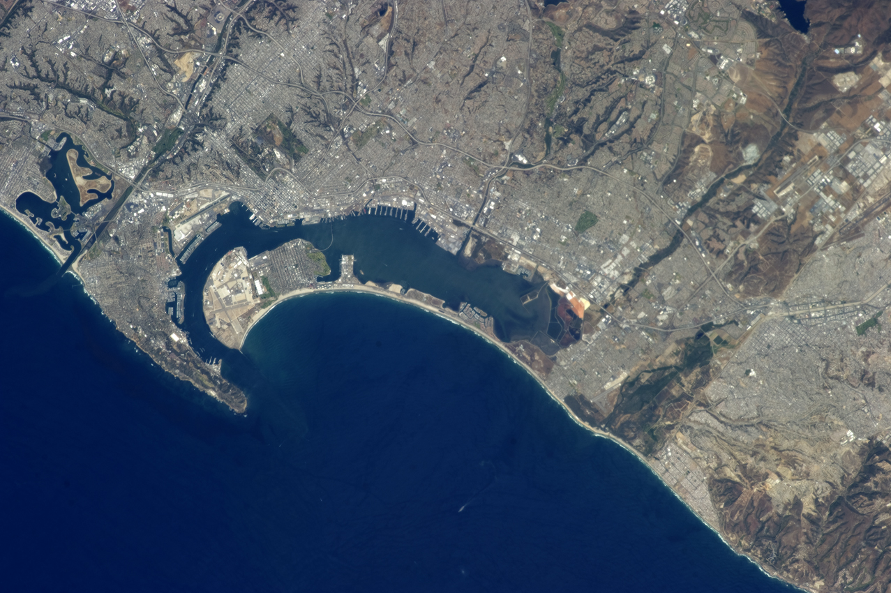
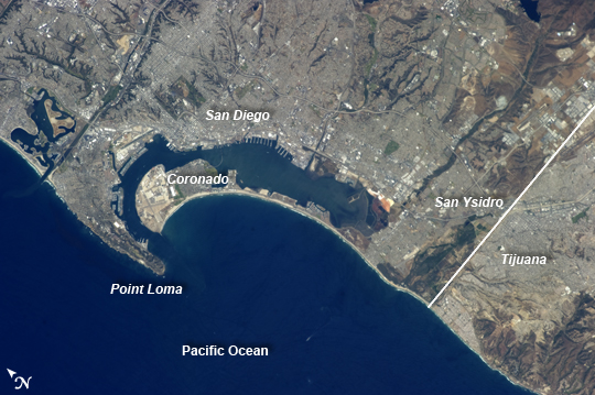
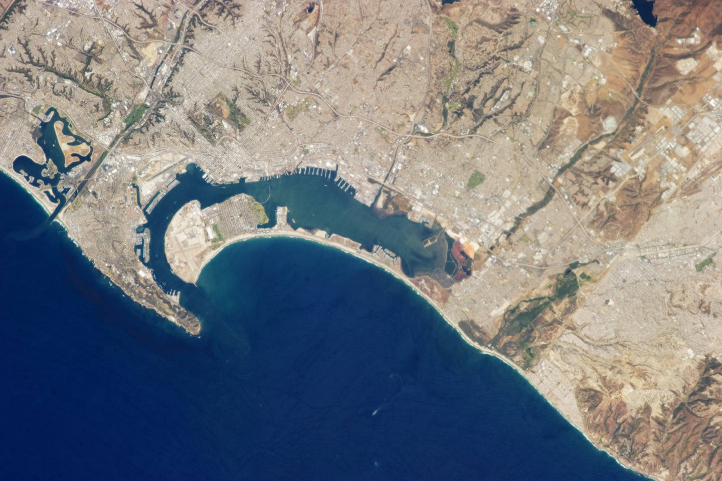
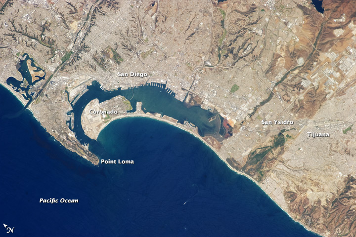
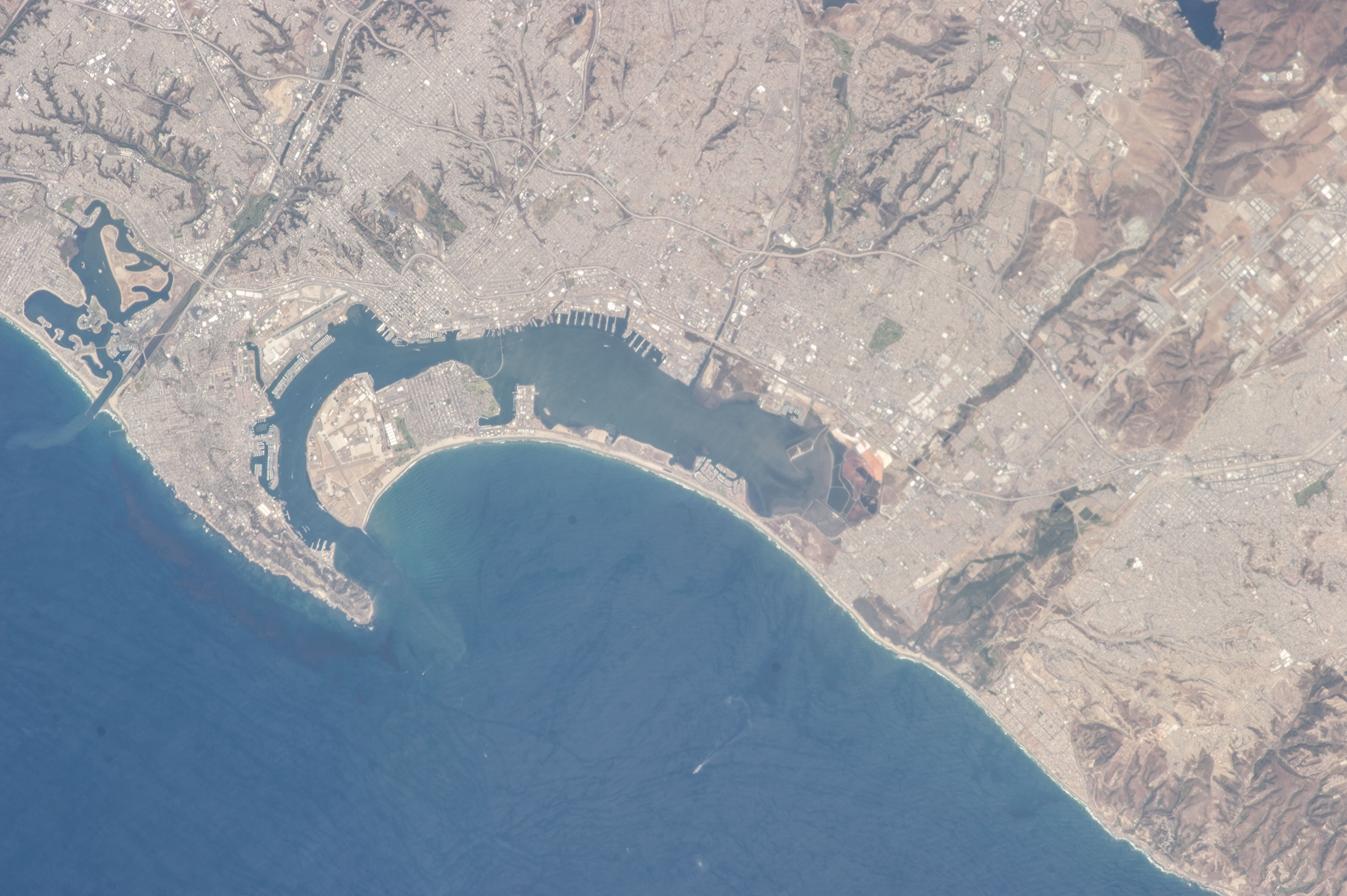
Image Caption: San Diego-Tijuana Region, USA and Mexico
The metropolitan areas of San Diego, California, USA; and Tijuana, Baja California, Mexico together form an international conurbation that crosses the USA-Mexico border (white line) at the northern end of the peninsula of Baja California near the city of San Ysidro, CA. This detailed astronaut photograph, taken from the International Space Station, highlights the region. Urban and suburban areas appear a light gray, speckled with white rooftops indicating large industrial and commercial buildings and centers. Vegetated areas - parks, golf courses, and the foothills of nearby mountains - appear green, in contrast to the tan and dark brown of exposed soils and bedrock in highland areas.
The city of San Diego was founded in 1769 by Franciscan friar Junipero Serra. While the valley of Tijuana was explored at this time, the city of Tijuana would not be founded until 1889. Today, the San Diego-Tijuana conurbation also includes the cities of Chula Vista, Carlsbad, San Marcos, National City in the USA; and Tecate, and Rosarito Beach in Mexico. The combined population of the region is approximately 5 million according to 2010 census information from both the USA and Mexico.
The city of Coronado CA, situated on an artificial peninsula across the bay from San Diego, is both a popular beach resort and the location of US Navy air station and training facilities. Point Loma defines the western boundary of San Diego Bay, and is part of the city of San Diego. While the northern half of the Point Loma peninsula hosts various residential communities, the southern half is federal land occupied by US Navy installations, the Fort Rosecrans National Cemetery and the Cabrillo National Monument that marks the landing of the first European on the west coast of the United States.
