ISS034-E-57550

| NASA Photo ID | ISS034-E-57550 |
| Focal Length | 400mm |
| Date taken | 2013.02.28 |
| Time taken | 17:29:53 GMT |
Resolutions offered for this image:
1000 x 665 pixels 540 x 359 pixels 1440 x 960 pixels 720 x 480 pixels 4256 x 2832 pixels 640 x 426 pixels
1000 x 665 pixels 540 x 359 pixels 1440 x 960 pixels 720 x 480 pixels 4256 x 2832 pixels 640 x 426 pixels
Cloud masks available for this image:
Spacecraft nadir point: 35.4° N, 100.2° W
Photo center point: 35.0° N, 101.8° W
Photo center point by machine learning:
Photo center point: 35.0° N, 101.8° W
Photo center point by machine learning:
Nadir to Photo Center: West
Spacecraft Altitude: 218 nautical miles (404km)
Country or Geographic Name: | USA-TEXAS |
Features: | PALO DURO CANYON, SNOW, CANYON, LAKE TANGLEWOOD |
| Features Found Using Machine Learning: | |
Cloud Cover Percentage: | 10 (1-10)% |
Sun Elevation Angle: | 43° |
Sun Azimuth: | 151° |
Camera: | Nikon D3S Electronic Still Camera |
Focal Length: | 400mm |
Camera Tilt: | 24 degrees |
Format: | 4256E: 4256 x 2832 pixel CMOS sensor, 36.0mm x 23.9mm, total pixels: 12.87 million, Nikon FX format |
Film Exposure: | |
| Additional Information | |
| Width | Height | Annotated | Cropped | Purpose | Links |
|---|---|---|---|---|---|
| 1000 pixels | 665 pixels | No | Yes | Earth From Space collection | Download Image |
| 540 pixels | 359 pixels | Yes | Yes | Earth From Space collection | Download Image |
| 1440 pixels | 960 pixels | No | Yes | NASA's Earth Observatory web site | Download Image |
| 720 pixels | 480 pixels | Yes | No | Download Image | |
| 4256 pixels | 2832 pixels | No | No | Download Image | |
| 640 pixels | 426 pixels | No | No | Download Image |
Download Packaged File
Download a Google Earth KML for this Image
View photo footprint information
Download a GeoTIFF for this photo
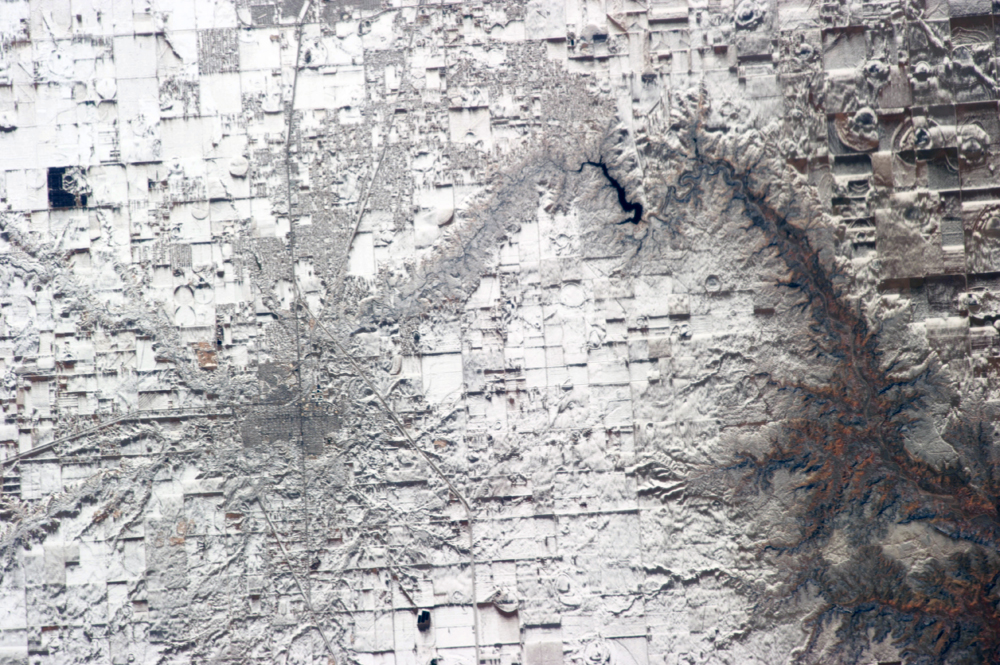
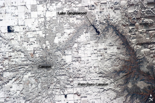
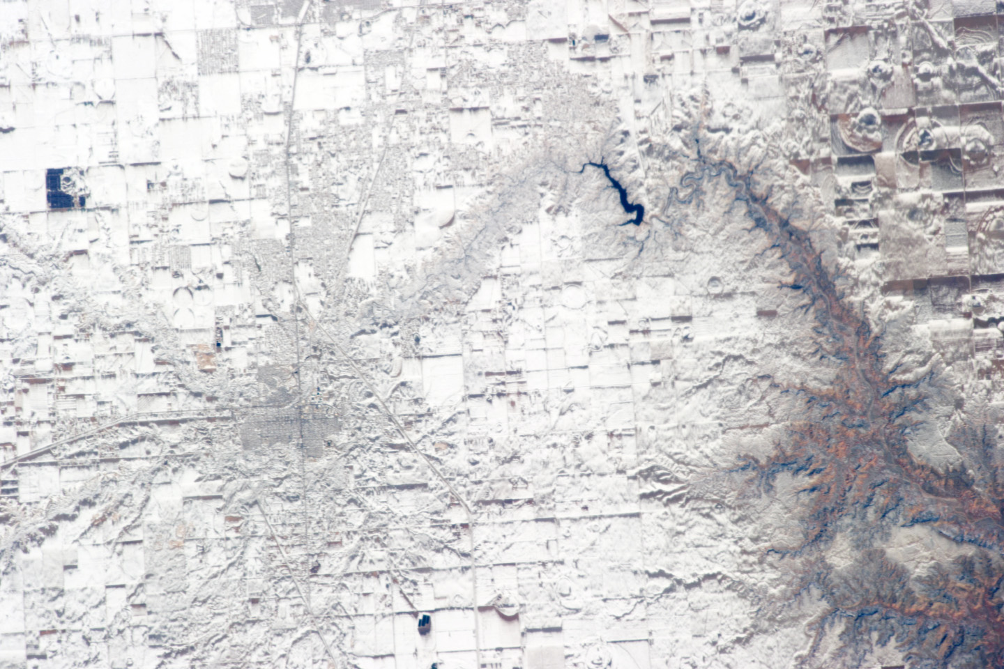
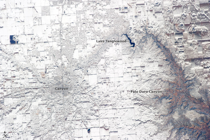
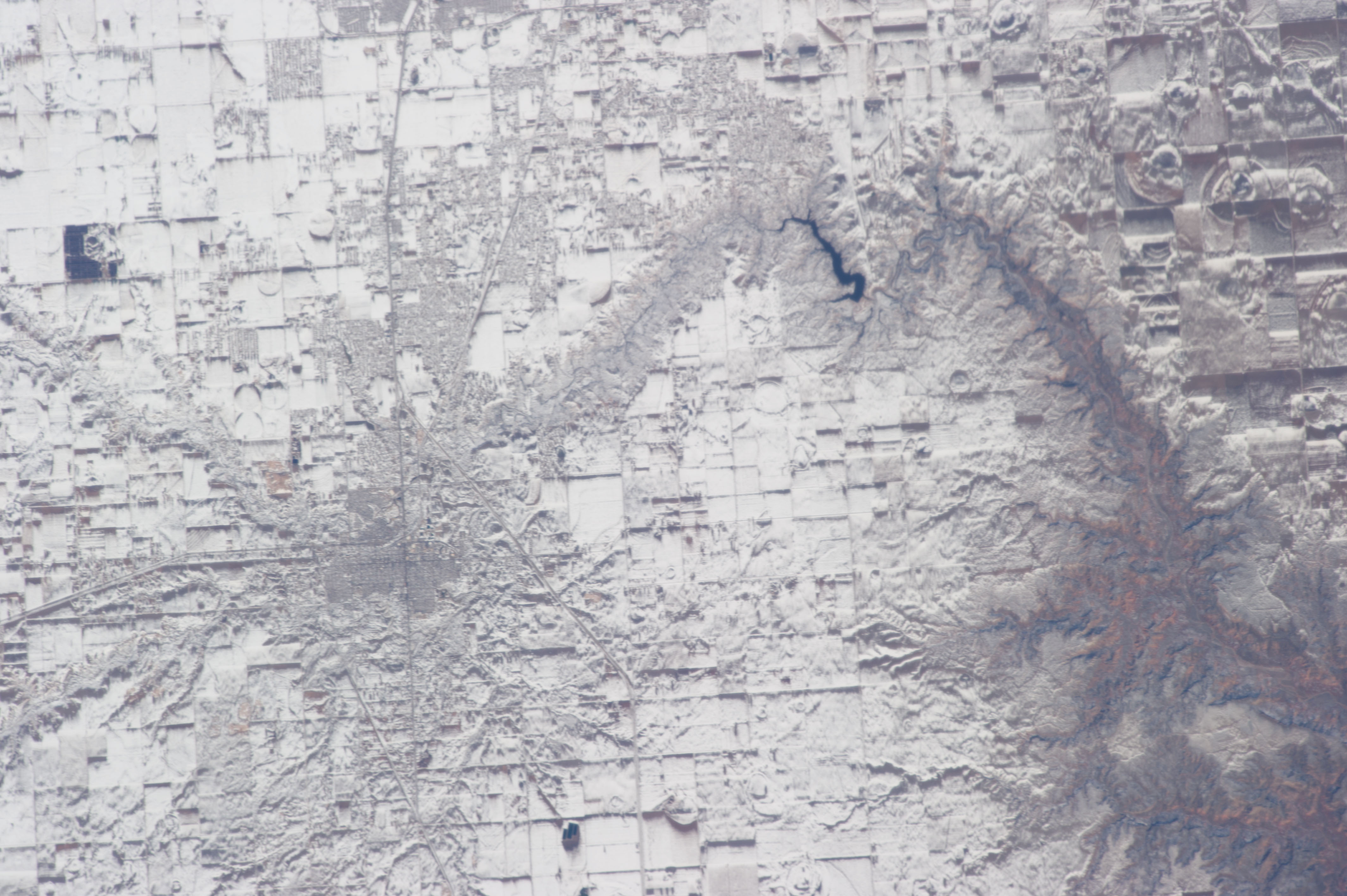
Image Caption: Record Snowfall in North Texas
The winter season of 2012-2013 has been marked by powerful snowstorms with record-setting levels of snowfall throughout much of the Midwestern United States. This astronaut photograph, taken from the International Space Station, features the Southern High Plains of north Texas directly south of the city of Amarillo, TX (off image to the north). The snowstorm that had passed through this area before the image was taken left a record snowfall of approximately 43 centimeters (17 inches).
Snow blankets the city of Canyon, TX at image left. Urban area street grids and stream channels appear etched into the landscape by the snow - a result of both melting and street clearing in the urban regions, and the incised nature of the stream channels into the surrounding plains. Palo Duro Canyon at image right is largely free of snow along the Prairie Dog Town Fork of the Red River channel and lower elevations, allowing the red sedimentary rocks forming the canyon walls to be visible. Agricultural fields in the area are easily identified due to the even snow cover broken only by roadways between the fields.
Lake Tanglewood, a reservoir located to the northeast of Canyon appears dark due to a lack of ice cover. Another dark region to the northwest of Canyon is a feed yard for cattle; any snowfall is this area has been removed by the actions of the livestock.
