ISS033-E-14856
| NASA Photo ID | ISS033-E-14856 |
| Focal Length | 70mm |
| Date taken | 2012.10.13 |
| Time taken | 22:27:50 GMT |
Resolutions offered for this image:
1000 x 665 pixels 540 x 359 pixels 1440 x 958 pixels 720 x 480 pixels 4256 x 2832 pixels 640 x 426 pixels
1000 x 665 pixels 540 x 359 pixels 1440 x 958 pixels 720 x 480 pixels 4256 x 2832 pixels 640 x 426 pixels

Cloud masks available for this image:
Spacecraft nadir point: 23.4° N, 51.6° E
Photo center point: 25.0° N, 51.5° E
Photo center point by machine learning:
Photo center point: 25.0° N, 51.5° E
Photo center point by machine learning:
Nadir to Photo Center: North
Spacecraft Altitude: 216 nautical miles (400km)
Country or Geographic Name: | QATAR |
Features: | QATAR AT NIGHT, BAHRAIN AT NIGHT |
| Features Found Using Machine Learning: | |
Cloud Cover Percentage: | 0 (no clouds present) |
Sun Elevation Angle: | -56° |
Sun Azimuth: | 69° |
Camera: | Nikon D3S Electronic Still Camera |
Focal Length: | 70mm |
Camera Tilt: | 24 degrees |
Format: | 4256E: 4256 x 2832 pixel CMOS sensor, 36.0mm x 23.9mm, total pixels: 12.87 million, Nikon FX format |
Film Exposure: | |
| Additional Information | |
| Width | Height | Annotated | Cropped | Purpose | Links |
|---|---|---|---|---|---|
| 1000 pixels | 665 pixels | No | Yes | Earth From Space collection | Download Image |
| 540 pixels | 359 pixels | Yes | Yes | Earth From Space collection | Download Image |
| 1440 pixels | 958 pixels | No | Yes | NASA's Earth Observatory web site | Download Image |
| 720 pixels | 480 pixels | Yes | No | NASA's Earth Observatory web site | Download Image |
| 4256 pixels | 2832 pixels | No | No | Download Image | |
| 640 pixels | 426 pixels | No | No | Download Image |
Download Packaged File
Download a Google Earth KML for this Image
View photo footprint information
Download a GeoTIFF for this photo
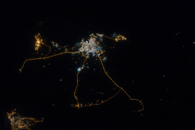
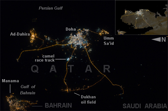
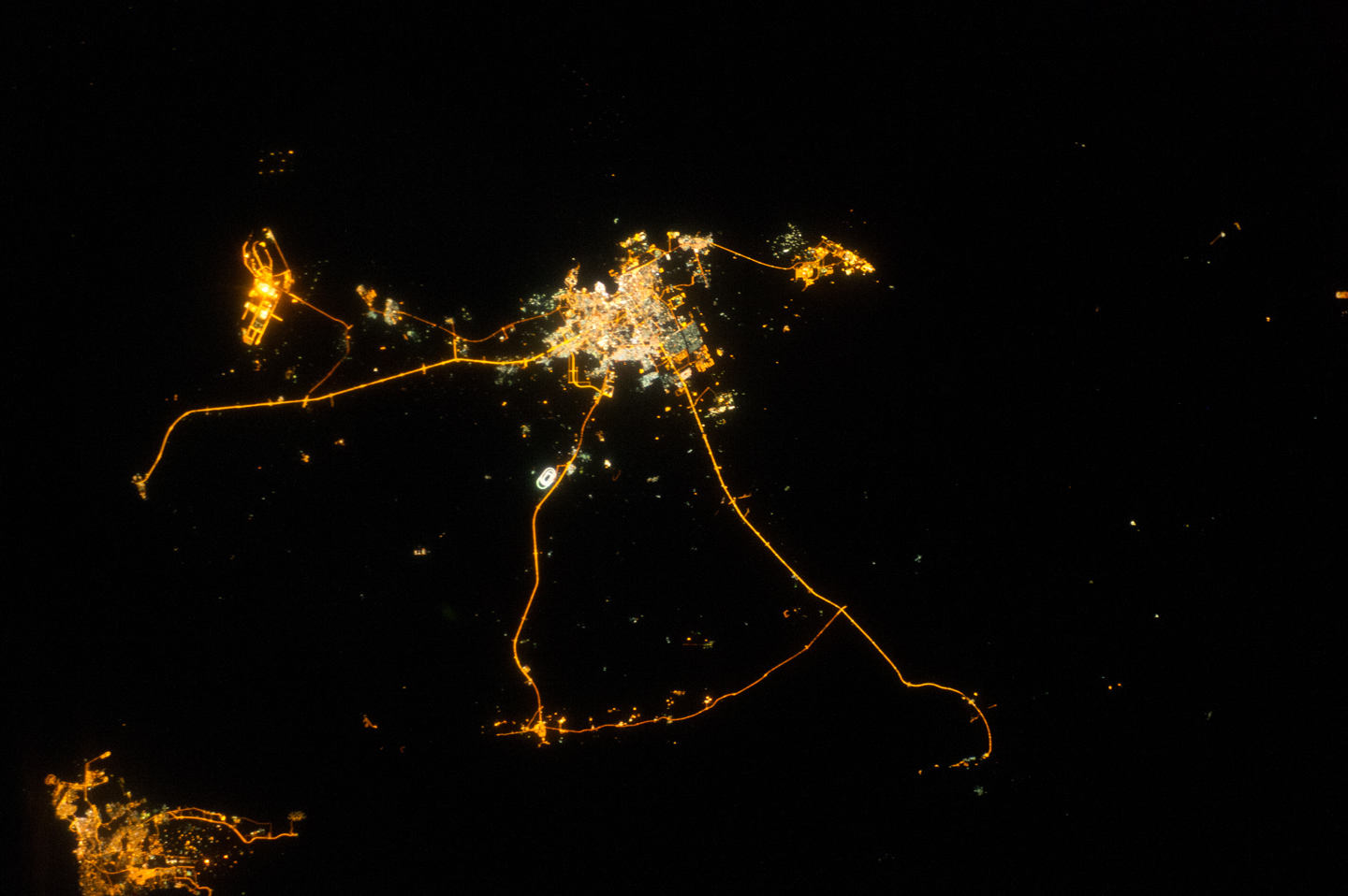
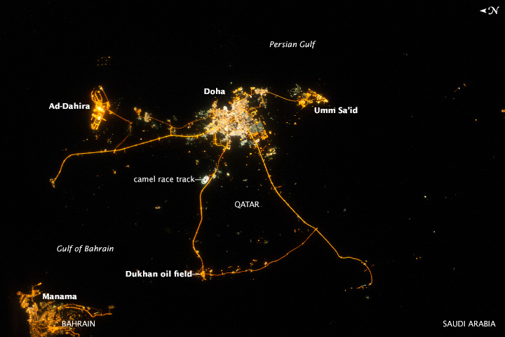
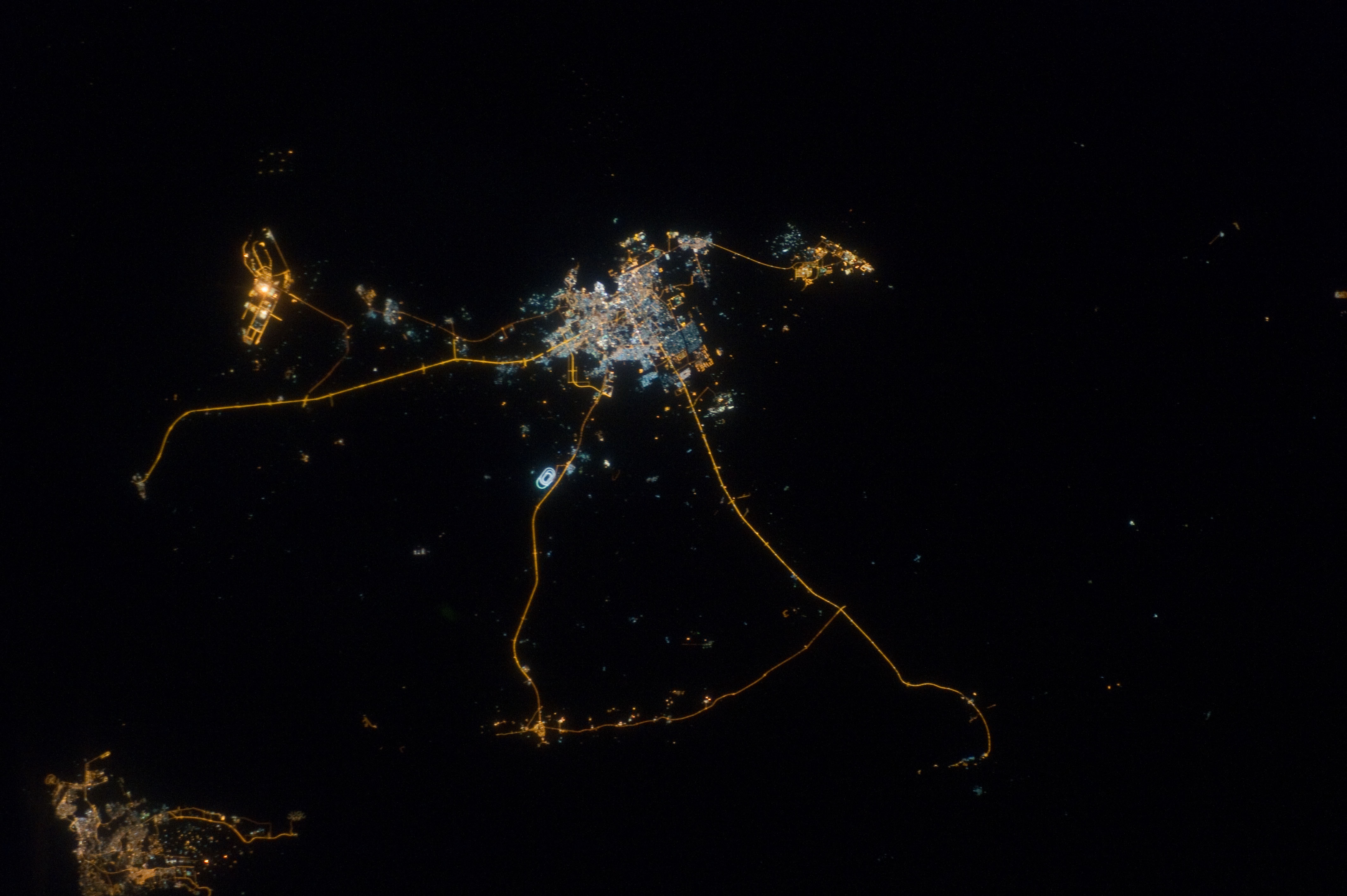
Image Caption: Qatar, Persian Gulf, at Night
Night lights can be very revealing regarding the distribution of people on the landscape. Here the lights of Qatar show the precise demographic geography of the country. The brightest group at image center shows the capital city Doha with the neighboring smaller ports of Ad-Dahira and Umm Sa'id to the north and south, respectively. Even highways and their relative importance can be discerned. Highways are clearly visible leading from the capital west to the Dukhan oil fields, to Saudi Arabia, and to the north of the country--where, judging by the lack of night lights, the population is very low. The relatively minor coast road between the oil fields and the Saudi frontier also stands out. This kind of highly informative human geographic detail is very difficult to discern in daylight images, in which even larger cities, especially in deserts, are hard to see.
Almost the entire island nation of Bahrain appears at lower left, with its capital city Manama nearly as bright as the lights of Doha. The difference in light intensity reflects a difference in population--Doha has 1.45 million inhabitants, while the very dense Manama metro area has a population of 1.2 million.
While some night views are highly informative about a landscape, they can also be difficult and confusing to locate. Astronauts learn to recognize where they are at night by flying over populated places repeatedly, even though coastlines--one of their best geographic indicators--are generally lost to view because water surfaces and unpopulated land surfaces look the same without illumination (such as from a full moon). Thus the thumb-shaped Qatari peninsula, so well-known in Middle Eastern geography, cannot be discerned at all in this night image.
