ISS032-E-6129
| NASA Photo ID | ISS032-E-6129 |
| Focal Length | 1200mm |
| Date taken | 2012.07.10 |
| Time taken | 06:12:56 GMT |
Resolutions offered for this image:
1000 x 667 pixels 540 x 360 pixels 720 x 480 pixels 6048 x 4032 pixels 640 x 427 pixels
1000 x 667 pixels 540 x 360 pixels 720 x 480 pixels 6048 x 4032 pixels 640 x 427 pixels
Cloud masks available for this image:
Spacecraft nadir point: 45.2° N, 37.6° E
Photo center point: 44.9° N, 38.0° E
Photo center point by machine learning: 44.93° N, 38.01° E
Photo center point: 44.9° N, 38.0° E
Photo center point by machine learning: 44.93° N, 38.01° E
Nadir to Photo Center: Southeast
Spacecraft Altitude: 211 nautical miles (391km)
Country or Geographic Name: | RUSSIAN FEDERATION |
Features: | KRYMSK, FLOODING, AGRICULTURE, URBAN AREA |
| Features Found Using Machine Learning: | |
Cloud Cover Percentage: | 10 (1-10)% |
Sun Elevation Angle: | 43° |
Sun Azimuth: | 102° |
Camera: | Nikon D3X Electronic Still Camera |
Focal Length: | 1200mm |
Camera Tilt: | 08 degrees |
Format: | 6048E: 6048 x 4032 pixel CMOS sensor, 35.9mm x 24.0mm, total pixels: 25.72 million, Nikon FX format |
Film Exposure: | |
| Additional Information | |
| Width | Height | Annotated | Cropped | Purpose | Links |
|---|---|---|---|---|---|
| 1000 pixels | 667 pixels | No | Yes | Earth From Space collection | Download Image |
| 540 pixels | 360 pixels | Yes | Yes | Earth From Space collection | Download Image |
| 720 pixels | 480 pixels | Yes | Yes | NASA's Earth Observatory web site | Download Image |
| 6048 pixels | 4032 pixels | No | No | Download Image | |
| 640 pixels | 427 pixels | No | No | Download Image |
Download Packaged File
Download a Google Earth KML for this Image
View photo footprint information
Download a GeoTIFF for this photo
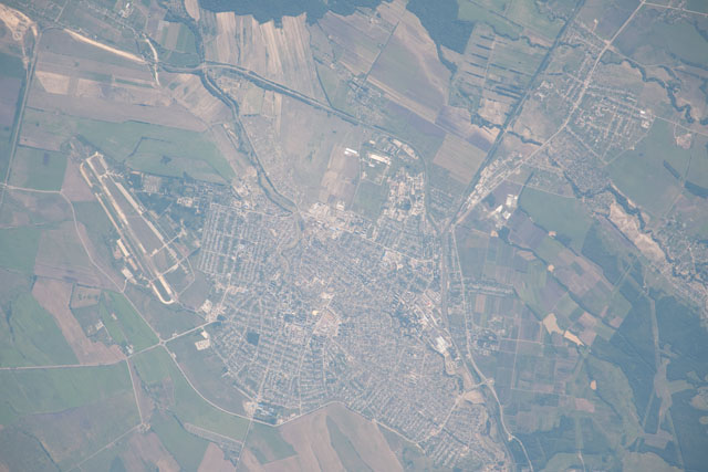
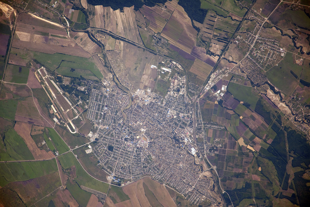
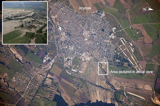
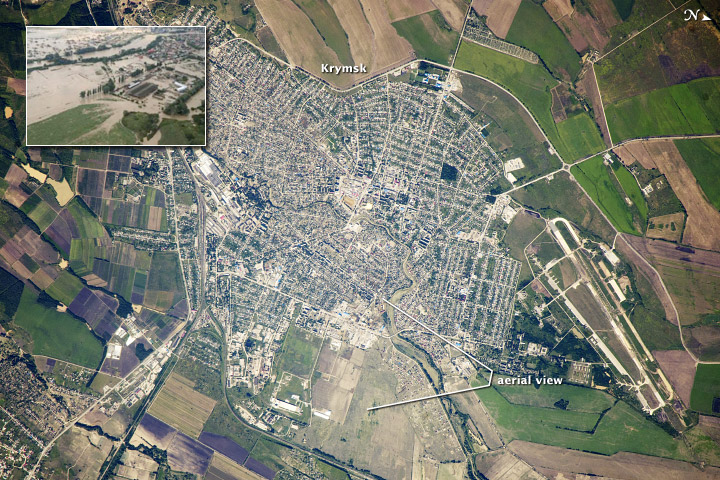
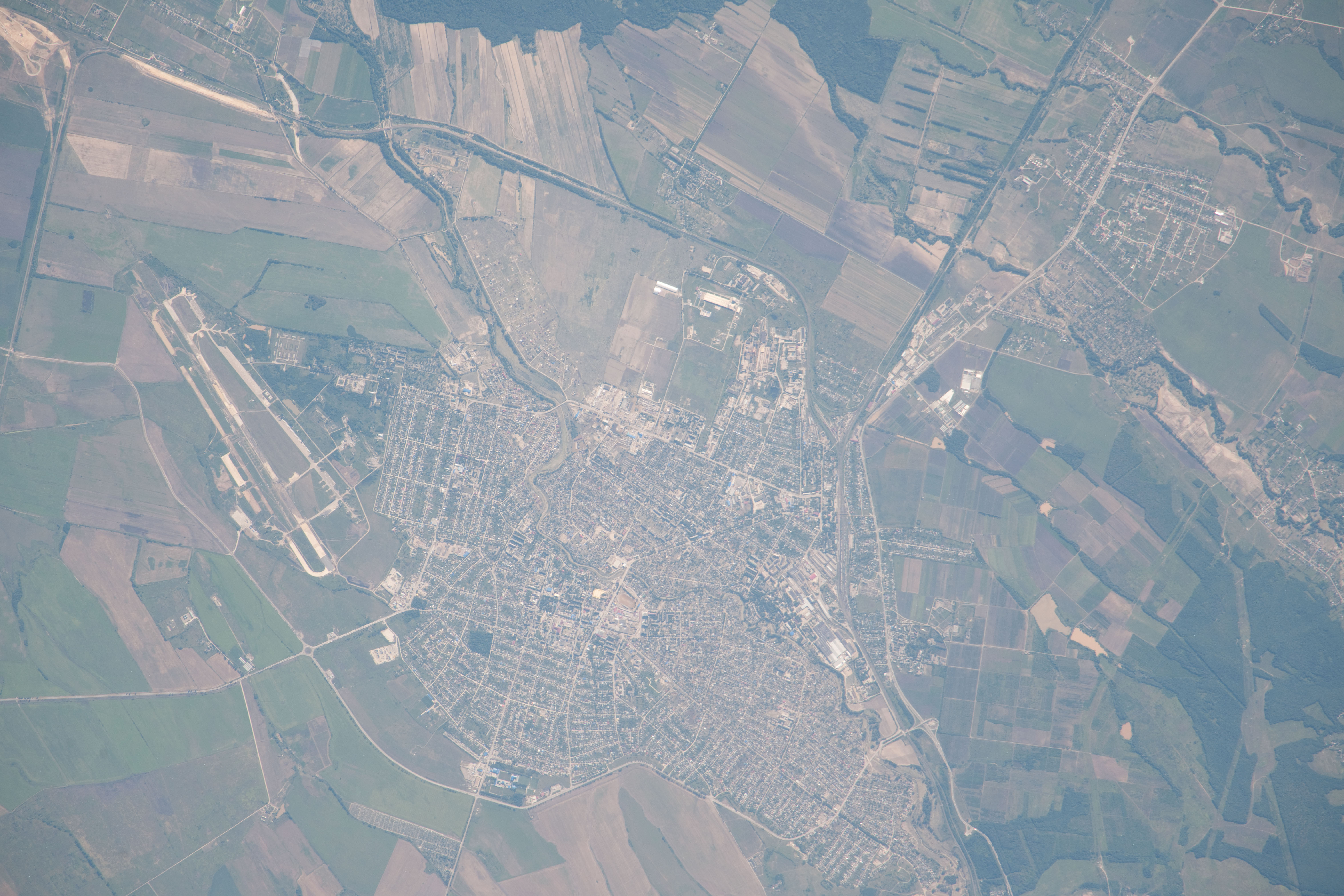
Image Caption: Flooding in Krymsk, Krasnodar region, Southern Russia
Note: This caption refers to the image versions labeled "NASA's Earth Observatory web site".
On the night of July 7, 2012 a major storm dumped more than a foot of water on the southern Russian area of Krasnodar, near the Black Sea. The resulting flood was likened to a tsunami, and to date, more than 170 people died, most from the city of Krymsk. The Moscow times reports that more than 19,000 people lost everything.
This image taken by cosmonauts aboard the International Space Station shows the city of Krymsk. For context, an aerial view (inset) that was posted in the Moscow Times shows the flooding of the Kuban River tributary that flows through the center of the city, three days before the astronaut photograph was taken - the box denotes the area represented by that photo. Regions that were flooded along the channel have tan to brown coloration in the astronaut photograph. The color is probably due to the mud and debris that was left behind by the floodwaters.
Krymsk is located in the western foothills on the northern slope of the Caucasus Mountains--a range that stretches between the Black Sea and the Caspian Sea. The vast amount of rain quickly overwhelmed the small river channels that flow northward from the mountains to the Russian lowlands and the Kuban River; Krymsk, located on one of those tributaries, was directly in the pathway of the flash flood.
As part of the international partner agreement to use the International Space Station to benefit humanity, crew members and other Earth observing instruments provide best-effort support to the International Disaster Charter (IDC) when it is activated by collecting imagery of areas on the ground impacted by natural events such as the flooding in Krymsk. This image was acquired July 10, 2012 in response to the IDC activation. Collected data may be used by relief efforts, or to communicate more clearly the geographic impacts of activation events through annotated maps.
