ISS030-E-174652
| NASA Photo ID | ISS030-E-174652 |
| Focal Length | 70mm |
| Date taken | 2012.02.28 |
| Time taken | 19:33:22 GMT |
Resolutions offered for this image:
1000 x 664 pixels 540 x 359 pixels 720 x 480 pixels 4288 x 2848 pixels 640 x 425 pixels
1000 x 664 pixels 540 x 359 pixels 720 x 480 pixels 4288 x 2848 pixels 640 x 425 pixels
Cloud masks available for this image:
Spacecraft nadir point: 35.5° N, 106.7° W
Photo center point: 33.0° N, 106.0° W
Photo center point by machine learning:
Photo center point: 33.0° N, 106.0° W
Photo center point by machine learning:
Nadir to Photo Center: South
Spacecraft Altitude: 203 nautical miles (376km)
Country or Geographic Name: | USA-NEW MEXICO |
Features: | WHITE SANDS NATIONAL MONUMENT, DUST PLUMES |
| Features Found Using Machine Learning: | |
Cloud Cover Percentage: | 10 (1-10)% |
Sun Elevation Angle: | 47° |
Sun Azimuth: | 185° |
Camera: | Nikon D2Xs Electronic Still Camera |
Focal Length: | 70mm |
Camera Tilt: | 37 degrees |
Format: | 4288E: 4288 x 2848 pixel CMOS sensor, RGBG imager color filter |
Film Exposure: | |
| Additional Information | |
| Width | Height | Annotated | Cropped | Purpose | Links |
|---|---|---|---|---|---|
| 1000 pixels | 664 pixels | No | Yes | Earth From Space collection | Download Image |
| 540 pixels | 359 pixels | Yes | Yes | Earth From Space collection | Download Image |
| 720 pixels | 480 pixels | Yes | Yes | NASA's Earth Observatory web site | Download Image |
| 4288 pixels | 2848 pixels | No | No | Download Image | |
| 640 pixels | 425 pixels | No | No | Download Image |
Download Packaged File
Download a Google Earth KML for this Image
View photo footprint information
Download a GeoTIFF for this photo
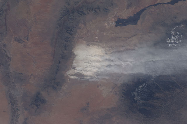
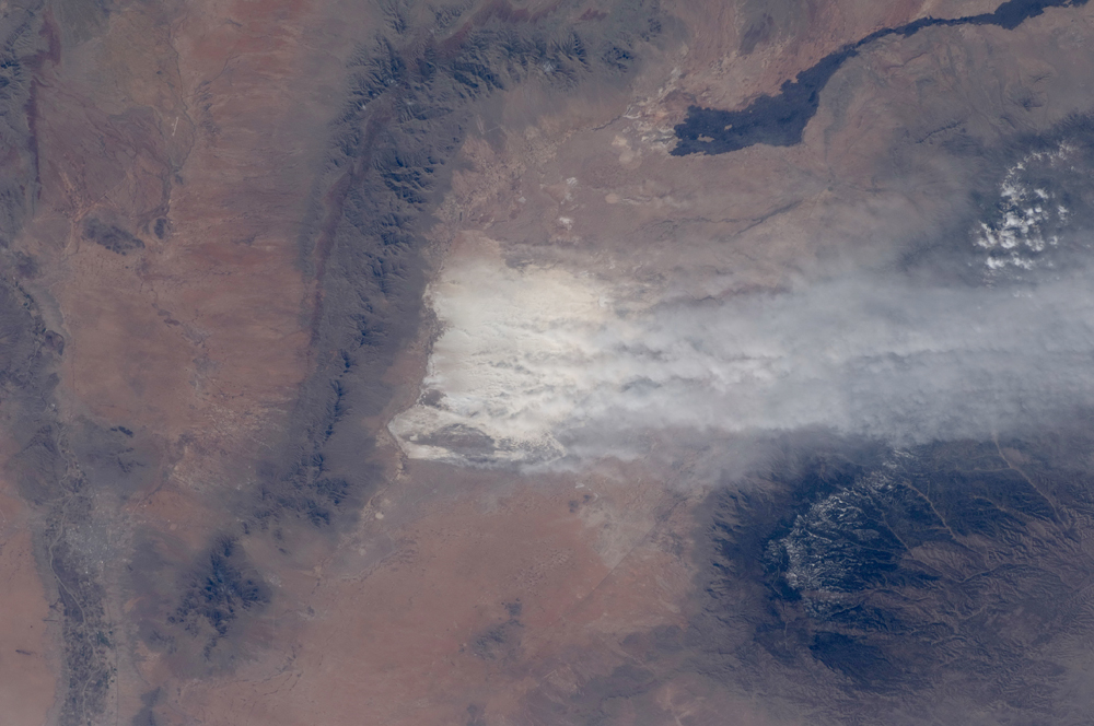
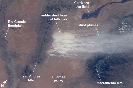
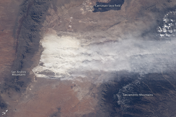
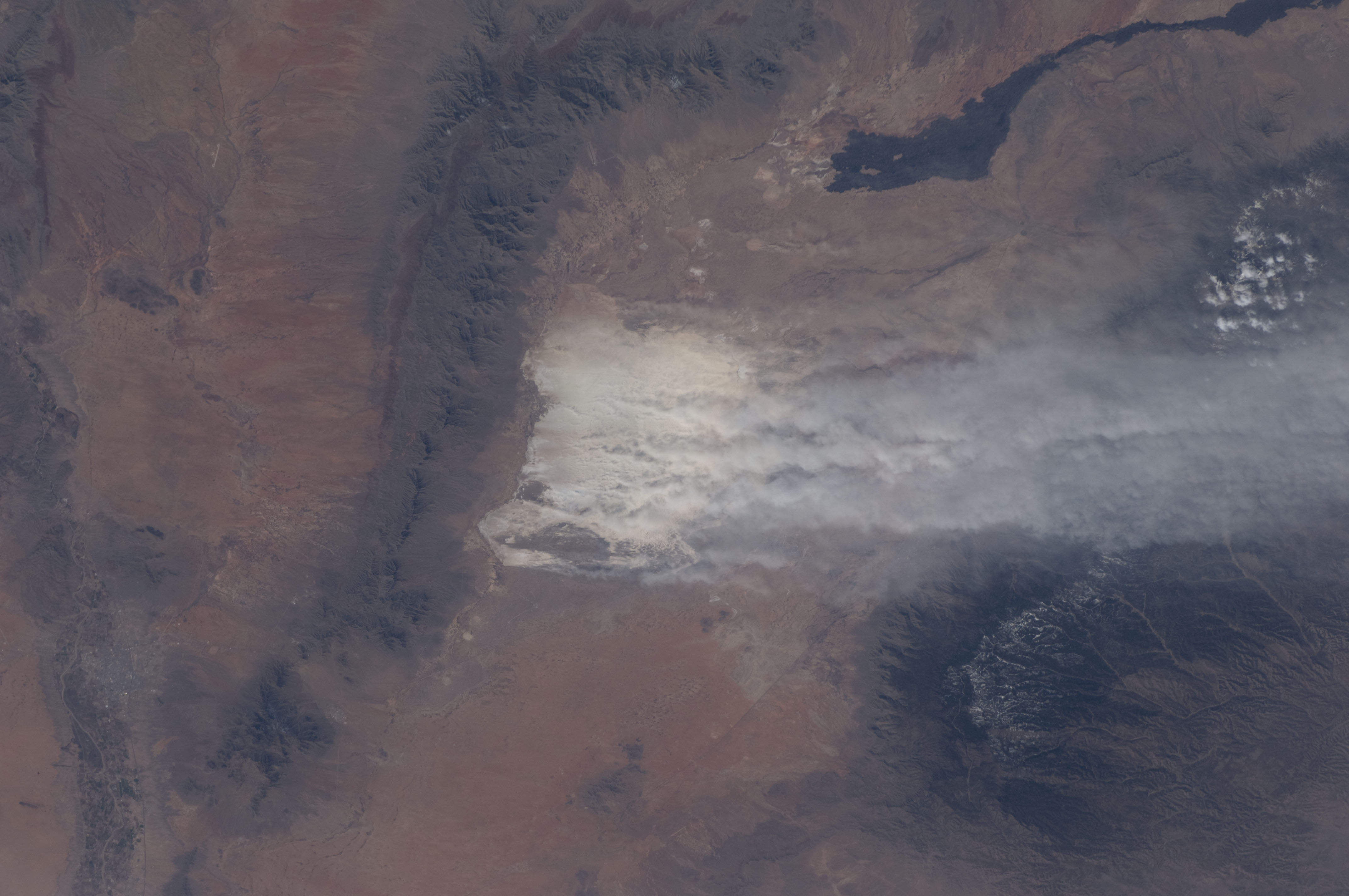
Image Caption: White Sands National Monument Dust Storm, New Mexico, USA
Driven by winter winds from the southwest, white dust from the White Sands dune field (image center) in New Mexico rises thousands of feet from the valley floor, up and over the snowy peaks of the Sacramento Mts. downwind (image right). White Sands National Monument lies in the 50 km-wide Tularosa valley, between the dark rocks and forested slopes of the Sacramento Mts. and the San Andres Mts. (image left center). The lower and warmer ridge line of the San Andres was without snow on this day. The striking black lava flows of the Carrizozo lava field also occupy the valley floor (image top right). The darker tones of agriculture in the Rio Grande floodplain can be seen along the left margin of the image.
The length of the dust plumes in this astronaut photograph is more than 120 km. The vigor of the winds on this day can be judged also from the fact that they are lifting the dust particles from the valley floor more than 1200 m over the mountains. Winds channel the dust through a low point on the Sacramento Mts., some 800 m below the ridge crests to north and south (image right).
In most parts of the world blowing dust is some shade of light brown or red. It is interesting to observe two colors of dust that contribute to this dust plume: redder dust from the local hillsides north of White Sands (seen by the small brown zone along the northern margin of the dust mass), and the white dust from the dune field.
The sand dunes of the Monument are white since they are composed of the mineral gypsum, a relatively rare dune-forming mineral. The gypsum is deposited during evaporation of mineral-rich waters in an ephemeral lake located in the western part of the Monument. Erosion of the deposits, together with wind transport, provides the granular material for the dunes. The dunes' brilliance, especially contrasted against the nearby dark mountain slopes, makes the dunes easily identifiable at great distances by orbiting astronauts. The white speck of the dunes is even visible in images taken looking back at Earth by crews on the way to the Moon.
