ISS027-E-20395

| NASA Photo ID | ISS027-E-20395 |
| Focal Length | 800mm |
| Date taken | 2011.05.02 |
| Time taken | 06:21:56 GMT |
Resolutions offered for this image:
1000 x 664 pixels 540 x 359 pixels 720 x 480 pixels 4288 x 2929 pixels 640 x 437 pixels
1000 x 664 pixels 540 x 359 pixels 720 x 480 pixels 4288 x 2929 pixels 640 x 437 pixels
Cloud masks available for this image:
Spacecraft nadir point: 51.2° N, 159.0° E
Photo center point: 53.2° N, 158.9° E
Photo center point by machine learning:
Photo center point: 53.2° N, 158.9° E
Photo center point by machine learning:
Nadir to Photo Center: North
Spacecraft Altitude: 183 nautical miles (339km)
Country or Geographic Name: | RUSSIAN FEDERATION |
Features: | AVACHINSKLY VOLCANO, KOZELSKY VOLCANO, CLOUDS |
| Features Found Using Machine Learning: | |
Cloud Cover Percentage: | 50 (26-50)% |
Sun Elevation Angle: | 21° |
Sun Azimuth: | 268° |
Camera: | Nikon D2Xs Electronic Still Camera |
Focal Length: | 800mm |
Camera Tilt: | 33 degrees |
Format: | 4288E: 4288 x 2848 pixel CMOS sensor, RGBG imager color filter |
Film Exposure: | |
| Additional Information | |
| Width | Height | Annotated | Cropped | Purpose | Links |
|---|---|---|---|---|---|
| 1000 pixels | 664 pixels | No | Yes | Earth From Space collection | Download Image |
| 540 pixels | 359 pixels | Yes | Yes | Earth From Space collection | Download Image |
| 720 pixels | 480 pixels | Yes | Yes | NASA's Earth Observatory web site | Download Image |
| 4288 pixels | 2929 pixels | No | No | Download Image | |
| 640 pixels | 437 pixels | No | No | Download Image |
Download Packaged File
Download a Google Earth KML for this Image
View photo footprint information
Download a GeoTIFF for this photo
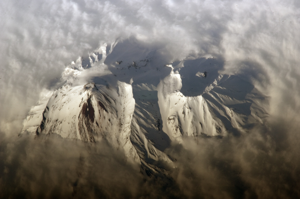
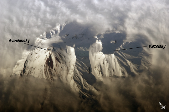
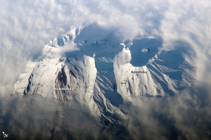
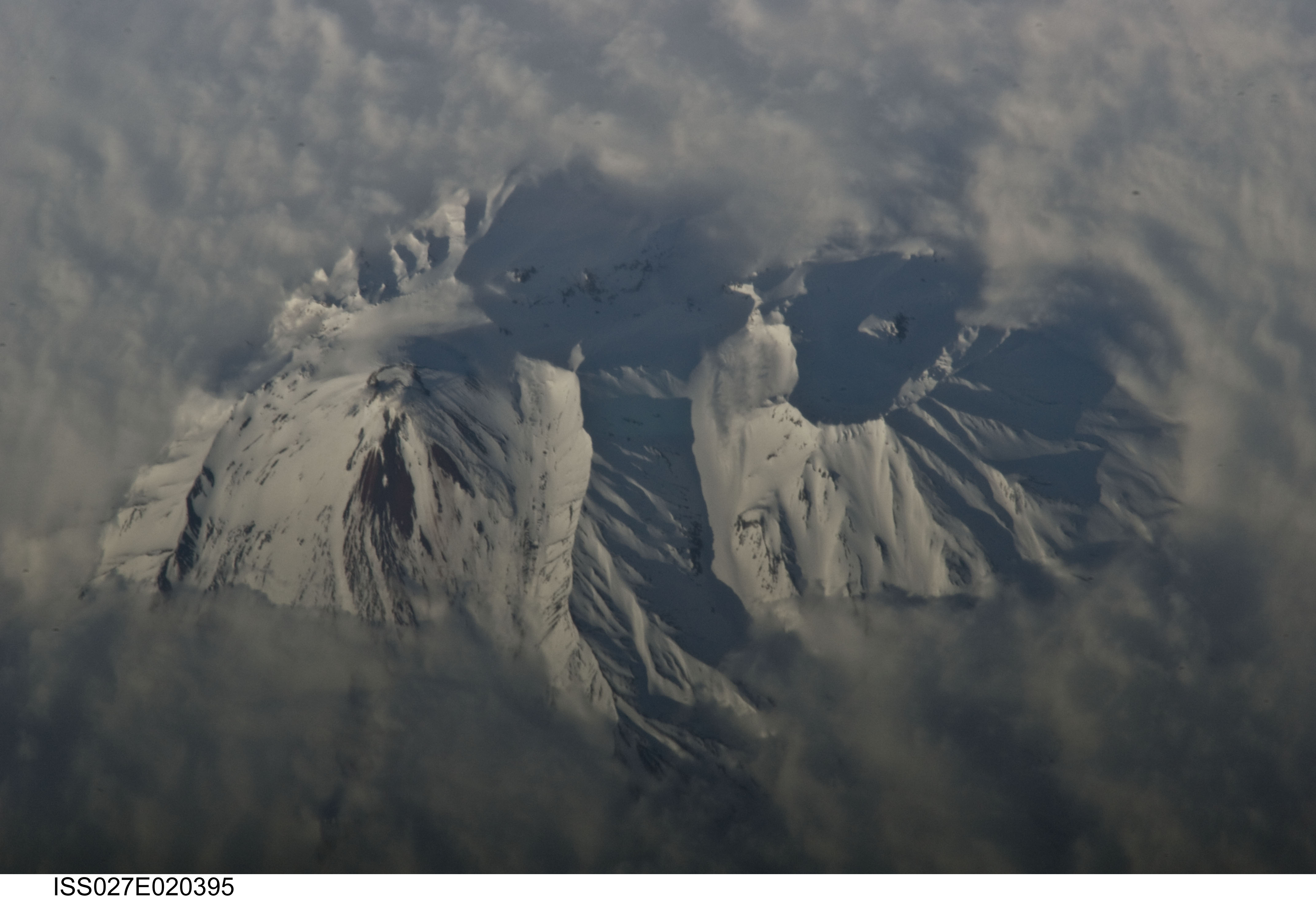
Image Caption: Avachinsky Volcano, Kamchatka Peninsula, Russia
The Kamchatka Peninsula of Russia, located along the Pacific "ring of fire", includes more than 100 identified volcanoes. While most of these volcanoes are not actively erupting, many are considered to be dangerous due to their past eruptive history and proximity to population centers and air travel corridors. This detailed astronaut photograph highlights the summit crater and snow-covered upper slopes of the Avachinsky stratovolcano exposed above a surrounding cloud deck.
The 2741 meter high Avachinsky volcano has an extensive historical and geological record of eruptions with the latest activity observed in 2008. The large city of Petropavlovsk, Kamchatka is located approximately 25 kilometers to the southwest and is built over approximately 30,000 - 40,000 year old debris avalanche deposits that originated from Avachinsky - suggesting that the city may be at risk from a similar hazard in the future. To the southeast (image right), the large breached crater of Kozelsky Volcano is also visible above the clouds. Kozelsky is a parasitic cone, formed by the eruption of material from vents along the flank of Avachinsky volcano.
The topography of the volcanoes is accentuated by shadows produced by the relatively low sun angle, and by the oblique viewing angle. Oblique images are taken looking outwards at an angle from the International Space Station, rather than the "straight down" (or nadir) view typical of most orbital Earth-observing sensor systems.
