ISS026-E-5121

| NASA Photo ID | ISS026-E-5121 |
| Focal Length | 800mm |
| Date taken | 2010.11.27 |
| Time taken | 18:55:38 GMT |
Resolutions offered for this image:
1000 x 664 pixels 540 x 360 pixels 540 x 359 pixels 720 x 480 pixels 4288 x 2929 pixels 640 x 437 pixels
1000 x 664 pixels 540 x 360 pixels 540 x 359 pixels 720 x 480 pixels 4288 x 2929 pixels 640 x 437 pixels

Cloud masks available for this image:
Spacecraft nadir point: 22.5° N, 76.2° W
Photo center point: 23.2° N, 75.2° W
Photo center point by machine learning:
Photo center point: 23.2° N, 75.2° W
Photo center point by machine learning:
Nadir to Photo Center: Northeast
Spacecraft Altitude: 190 nautical miles (352km)
Country or Geographic Name: | BAHAMAS |
Features: | LONG ISLAND, TIDAL FLATS, SCOUR CHANNELS |
| Features Found Using Machine Learning: | |
Cloud Cover Percentage: | 10 (1-10)% |
Sun Elevation Angle: | 37° |
Sun Azimuth: | 217° |
Camera: | Nikon D2Xs Electronic Still Camera |
Focal Length: | 800mm |
Camera Tilt: | 21 degrees |
Format: | 4288E: 4288 x 2848 pixel CMOS sensor, RGBG imager color filter |
Film Exposure: | |
| Additional Information | |
| Width | Height | Annotated | Cropped | Purpose | Links |
|---|---|---|---|---|---|
| 1000 pixels | 664 pixels | No | Yes | Earth From Space collection | Download Image |
| 540 pixels | 360 pixels | Yes | Yes | Earth From Space collection | Download Image |
| 540 pixels | 359 pixels | Yes | Yes | Earth From Space collection | Download Image |
| 720 pixels | 480 pixels | Yes | Yes | NASA's Earth Observatory web site | Download Image |
| 4288 pixels | 2929 pixels | No | No | Download Image | |
| 640 pixels | 437 pixels | No | No | Download Image |
Download Packaged File
Download a Google Earth KML for this Image
View photo footprint information
Download a GeoTIFF for this photo
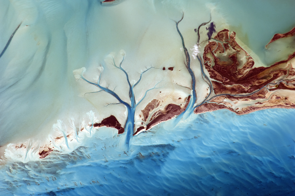
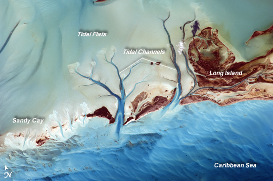
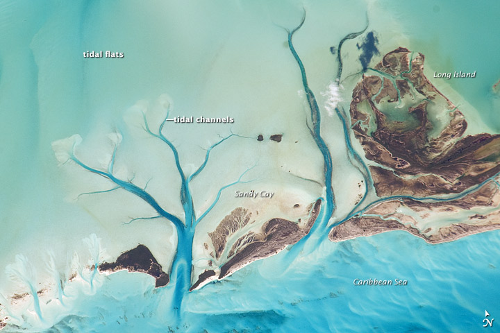
Image Caption: Tidal Flats and Channels, Long Island, Bahamas
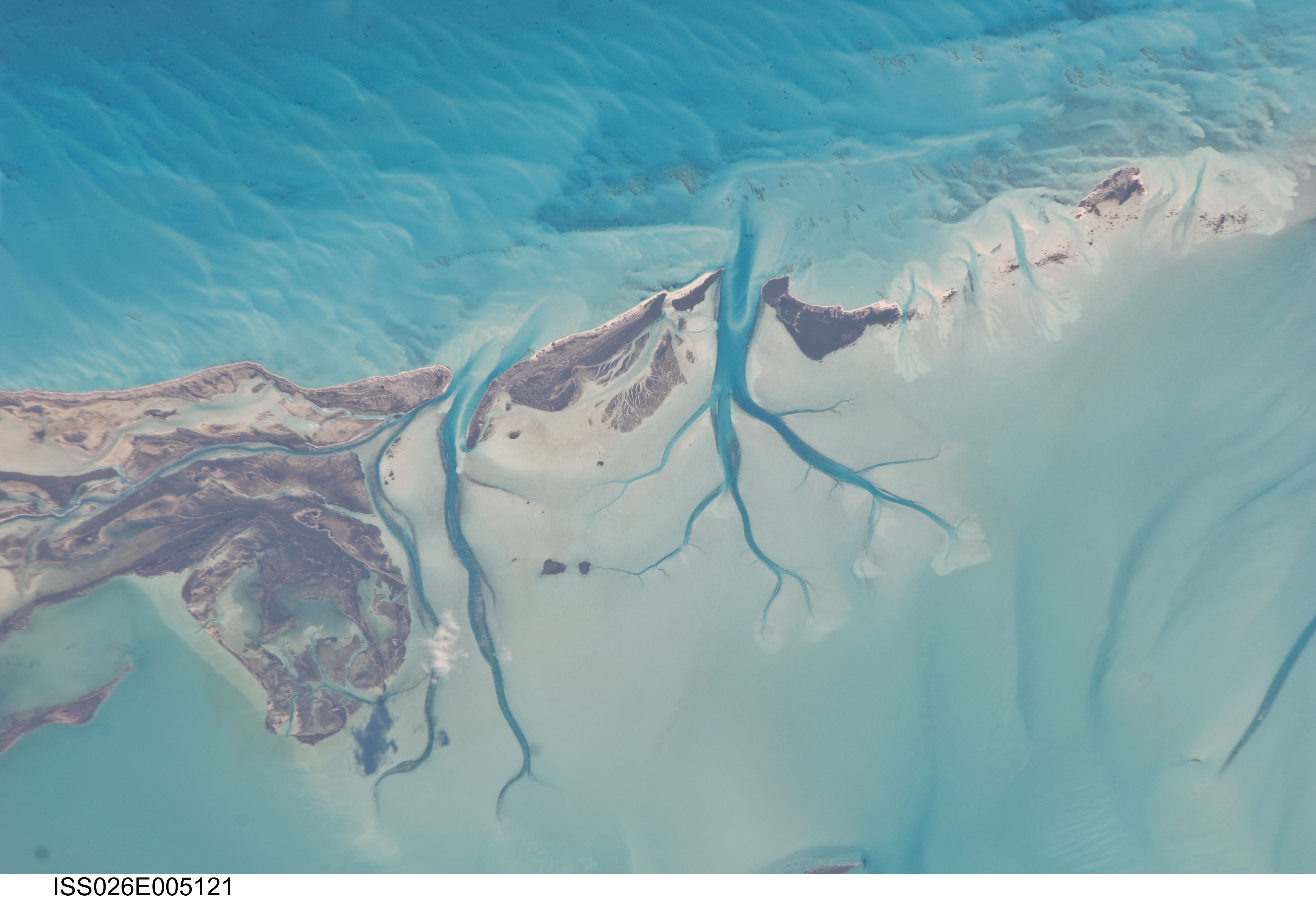
The islands of the Bahamas are situated on large depositional platforms--the Great and Little Bahama Banks--composed mainly of carbonate sediments ringed by reefs. The islands are the only parts of the platform currently exposed above sea level. The sediments were formed mostly from the skeletal remains of organisms settling to the sea floor; over geologic time, these sediments consolidated to form carbonate sedimentary rocks such as limestone.
This astronaut photograph provides a view of tidal flats and channels near Sandy Cay, on the western side of Long Island and along the eastern margin of the Great Bahama Bank. The continuously exposed parts of the island are brown, a result of soil formation and vegetation growth. To the north of Sandy Cay, an off-white tidal flat composed of carbonate sediments is visible; light blue-green regions indicate shallow water on the tidal flat. The tidal flow of seawater is concentrated through gaps in the land surface, leading to the formation of relatively deep channels that cut into the sediments. The channels and areas to the south of the island have a vivid blue color that indicates deeper water.
