ISS024-E-10403
| NASA Photo ID | ISS024-E-10403 |
| Focal Length | 400mm |
| Date taken | 2010.07.31 |
| Time taken | 20:01:23 GMT |
Resolutions offered for this image:
1000 x 664 pixels 540 x 359 pixels 720 x 480 pixels 4288 x 2929 pixels 640 x 437 pixels
1000 x 664 pixels 540 x 359 pixels 720 x 480 pixels 4288 x 2929 pixels 640 x 437 pixels

Cloud masks available for this image:
Spacecraft nadir point: 30.6° N, 95.3° W
Photo center point: 29.6° N, 95.1° W
Photo center point by machine learning:
Photo center point: 29.6° N, 95.1° W
Photo center point by machine learning:
Nadir to Photo Center: South
Spacecraft Altitude: 187 nautical miles (346km)
Country or Geographic Name: | USA-TEXAS |
Features: | JOHNSON SPACE CENTER, CLEAR LAKE, WEBSTER, GALVESTON BAY, SEABROOK, SUNGLINT |
| Features Found Using Machine Learning: | |
Cloud Cover Percentage: | 10 (1-10)% |
Sun Elevation Angle: | 65° |
Sun Azimuth: | 245° |
Camera: | Nikon D2Xs Electronic Still Camera |
Focal Length: | 400mm |
Camera Tilt: | 18 degrees |
Format: | 4288E: 4288 x 2848 pixel CMOS sensor, RGBG imager color filter |
Film Exposure: | |
| Additional Information | |
| Width | Height | Annotated | Cropped | Purpose | Links |
|---|---|---|---|---|---|
| 1000 pixels | 664 pixels | No | Yes | Earth From Space collection | Download Image |
| 540 pixels | 359 pixels | Yes | Yes | Earth From Space collection | Download Image |
| 720 pixels | 480 pixels | Yes | Yes | NASA's Earth Observatory web site | Download Image |
| 4288 pixels | 2929 pixels | No | No | Download Image | |
| 640 pixels | 437 pixels | No | No | Download Image |
Download Packaged File
Download a Google Earth KML for this Image
View photo footprint information
Download a GeoTIFF for this photo
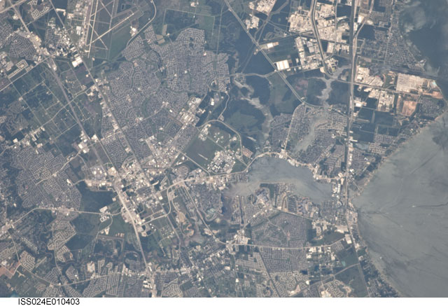
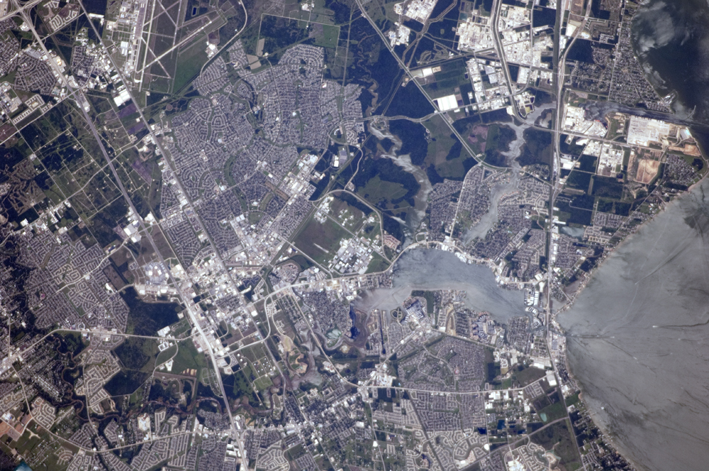
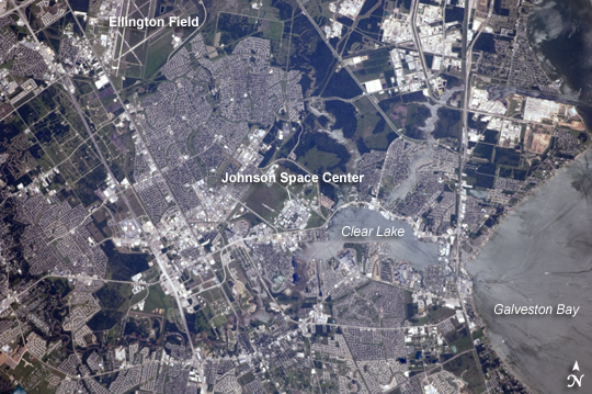
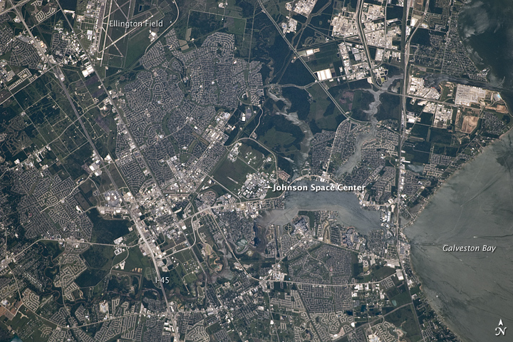
Image Caption: NASA Johnson Space Center, Houston, TX
This detailed astronaut photograph is centered on the NASA Lyndon B. Johnson Space Center (JSC), located in the southeastern Houston metropolitan area. The facility was established in 1961 as the Manned Spacecraft Center and renamed in honor of the late U.S. President Johnson (a Texas native) in 1973. JSC serves as the lead NASA center for both astronaut training and mission control of manned spacecraft--such as the International Space Station (ISS) and Space Shuttle--and has done so throughout the history of the U.S. manned space program. The Center also collaborates with other NASA and international partner facilities in a variety of scientific and engineering programs related to human space flight and planetary exploration.
JSC is located approximately midway between downtown Houston and Galveston, and is bordered by several smaller municipalities that form a mosaic of urban and suburban land use (grey areas with street grids, and commercial/industrial areas characterized by white rooftops). Large tracts of grassy fields and forests in the area (light to dark green respectively) include nature preserves, grazing lands, and flood control areas. Also visible at image upper left is Ellington Field. This airport services a variety of NASA aircraft used for astronaut training, scientific, and cargo transport purposes.
Clear Lake, an inlet of Galveston Bay, is located to the immediate southeast of JSC. Both Clear Lake and Galveston Bay appear silver-grey due to sunglint, or light reflected back towards the observer on the ISS that gives the water surface a mirror-like appearance. Several boat wakes are visible in Galveston Bay (image right) due to disruption of the water surface that reduces the sunglint effect.
Other astronaut photographs also feature the Houston and Galveston Bay area, including images of Houston at Night and the
Houston Ship Channel area.
