ISS022-E-15154
| NASA Photo ID | ISS022-E-15154 |
| Focal Length | 180mm |
| Date taken | 2009.12.24 |
| Time taken | 09:17:12 GMT |
Resolutions offered for this image:
1000 x 707 pixels 540 x 382 pixels 720 x 480 pixels 4288 x 2929 pixels 640 x 437 pixels
1000 x 707 pixels 540 x 382 pixels 720 x 480 pixels 4288 x 2929 pixels 640 x 437 pixels
Cloud masks available for this image:
Spacecraft nadir point: 22.9° S, 16.1° E
Photo center point: 24.7° S, 15.4° E
Photo center point by machine learning:
Photo center point: 24.7° S, 15.4° E
Photo center point by machine learning:
Nadir to Photo Center: South
Spacecraft Altitude: 185 nautical miles (343km)
Country or Geographic Name: | NAMIBIA |
Features: | NAMIB SAND SEA, SOSSUS VLEI |
| Features Found Using Machine Learning: | |
Cloud Cover Percentage: | 10 (1-10)% |
Sun Elevation Angle: | 68° |
Sun Azimuth: | 97° |
Camera: | Nikon D2Xs Electronic Still Camera |
Focal Length: | 180mm |
Camera Tilt: | 32 degrees |
Format: | 4288E: 4288 x 2848 pixel CMOS sensor, RGBG imager color filter |
Film Exposure: | |
| Additional Information | |
| Width | Height | Annotated | Cropped | Purpose | Links |
|---|---|---|---|---|---|
| 1000 pixels | 707 pixels | No | Yes | Earth From Space collection | Download Image |
| 540 pixels | 382 pixels | Yes | Yes | Earth From Space collection | Download Image |
| 720 pixels | 480 pixels | Yes | Yes | NASA's Earth Observatory web site | Download Image |
| 4288 pixels | 2929 pixels | No | No | Download Image | |
| 640 pixels | 437 pixels | No | No | Download Image |
Download Packaged File
Download a Google Earth KML for this Image
View photo footprint information
Download a GeoTIFF for this photo
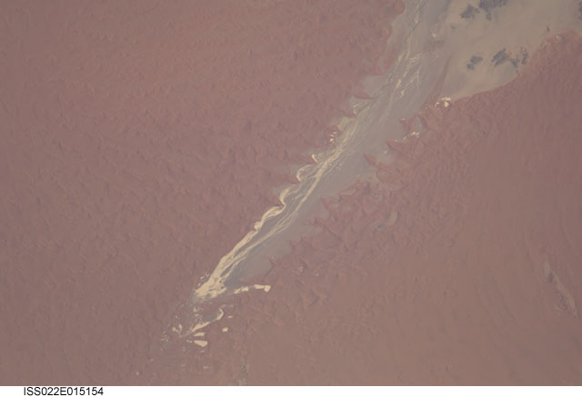
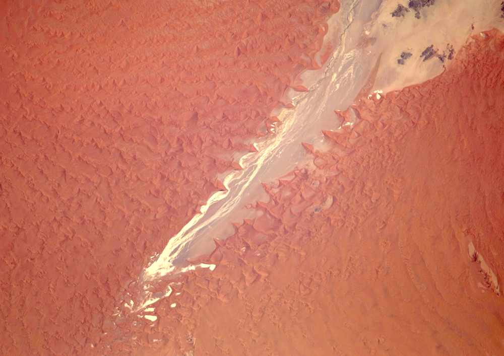
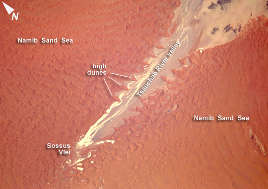
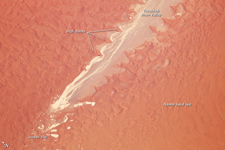
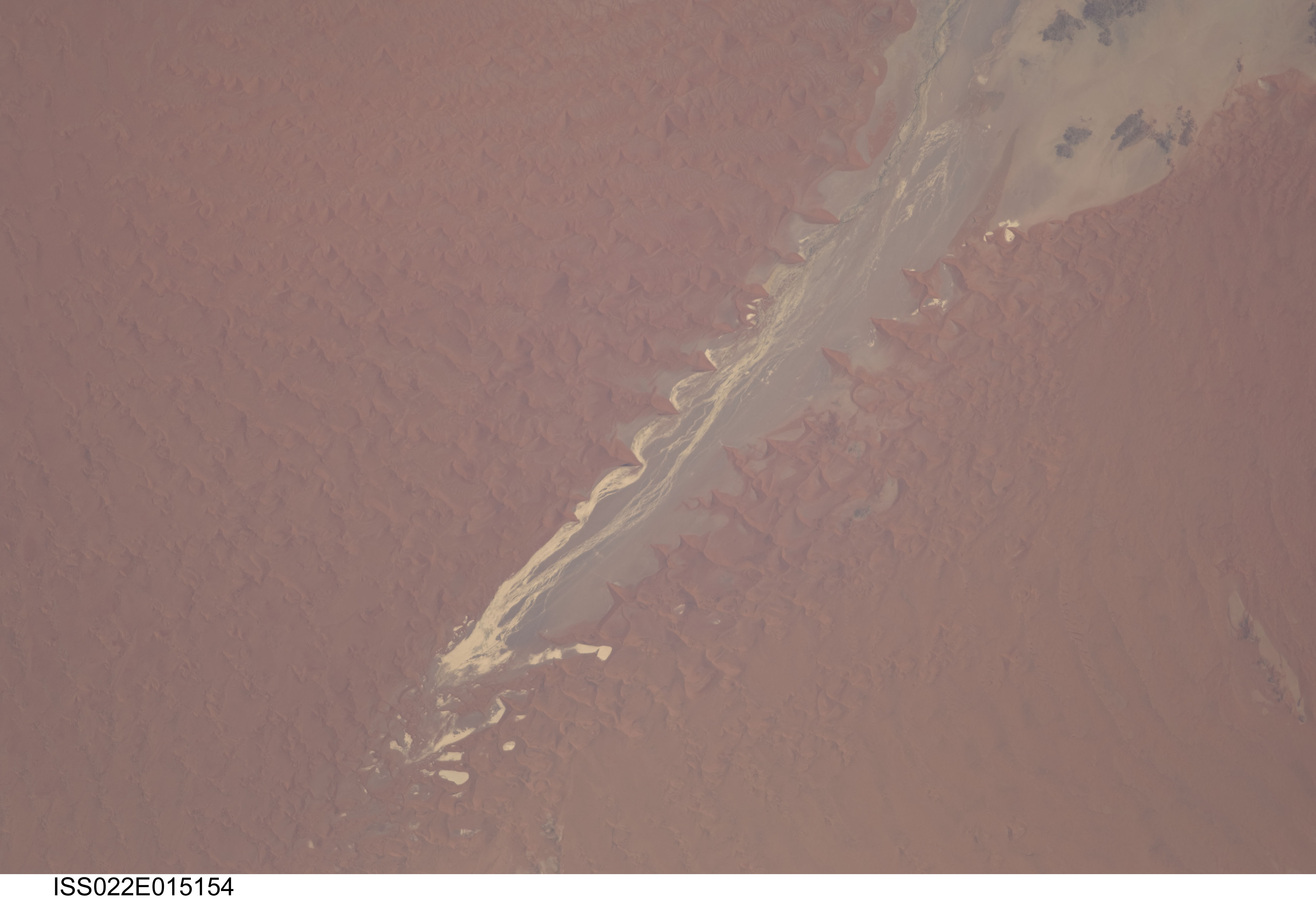
Image Caption: Tsauchab River and Sossus Vlei Lakebed, Namibia
Taken on Christmas Eve of 2009, this image shows the lower 45 kilometers of the Tsauchab River, a famous landmark for Namibians, tourists, and for orbiting astronauts. The Tsauchab River bed is seen jutting into the sea of red dunes near Namibia's hyper-arid coast. The riverbed ends in a series of light-colored, silty mud holes on the dry lake floor, known locally as Sossus Vlei ("small lake").
Because of the present arid climate, few people have ever seen the Tsauchab River with flowing water or a lake in Sossus Vlei. In times past, however, the Tsauchab appears to have reached the Atlantic coast, another 55 kilometers farther west. Like several other rivers of the coastal Namib Desert, the Tsauchab brings sediment down from the hinterland to the coastal lowland. This sediment is then blown from the river beds, and over probably tens of millions of years, has accumulated as the red dunes of the impressive Namib Sand Sea.
This astronaut photo shows sand heaped up in numerous star dunes, each of them with long arms extending in several directions. Unlike crescent-shaped barchan dunes, which form in areas where winds generally blow from one direction, star dunes are apparently generated where winds are variable. In this part of the Namib Sand Sea, winds are mainly from the south, but easterly winds, channeled along the Tsauchab valley, provide another component. And warm dry winter winds--similar to the Santa Ana winds of California--blow from the northeast.
These northeasterly winds are likely responsible for the regular dune arms that point into the valley from both sides. These large dunes facing the river valley are promoted as the highest dunes in the world. Although continuous dune slopes allow hikers to ascend to altitudes more than 300 meters above the river bottom, not all of that elevation gain has to be walked; the main base of the dunes lies on a terrace 180 meters above the river.
