ISS021-E-26475
| NASA Photo ID | ISS021-E-26475 |
| Focal Length | 800mm |
| Date taken | 2009.11.14 |
| Time taken | 13:04:57 GMT |
Resolutions offered for this image:
1000 x 662 pixels 540 x 357 pixels 720 x 480 pixels 4288 x 2929 pixels 640 x 437 pixels
1000 x 662 pixels 540 x 357 pixels 720 x 480 pixels 4288 x 2929 pixels 640 x 437 pixels

Cloud masks available for this image:
Spacecraft nadir point: 20.4° N, 21.4° E
Photo center point: 18.9° N, 20.9° E
Photo center point by machine learning:
Photo center point: 18.9° N, 20.9° E
Photo center point by machine learning:
Nadir to Photo Center: South
Spacecraft Altitude: 181 nautical miles (335km)
Country or Geographic Name: | CHAD |
Features: | OUNIANGA SERIR LAKE |
| Features Found Using Machine Learning: | |
Cloud Cover Percentage: | 0 (no clouds present) |
Sun Elevation Angle: | 34° |
Sun Azimuth: | 229° |
Camera: | Nikon D2Xs Electronic Still Camera |
Focal Length: | 800mm |
Camera Tilt: | 28 degrees |
Format: | 4288E: 4288 x 2848 pixel CMOS sensor, RGBG imager color filter |
Film Exposure: | |
| Additional Information | |
| Width | Height | Annotated | Cropped | Purpose | Links |
|---|---|---|---|---|---|
| 1000 pixels | 662 pixels | No | Yes | Earth From Space collection | Download Image |
| 540 pixels | 357 pixels | Yes | Yes | Earth From Space collection | Download Image |
| 720 pixels | 480 pixels | Yes | Yes | NASA's Earth Observatory web site | Download Image |
| 4288 pixels | 2929 pixels | No | No | Download Image | |
| 640 pixels | 437 pixels | No | No | Download Image |
Download Packaged File
Download a Google Earth KML for this Image
View photo footprint information
Download a GeoTIFF for this photo
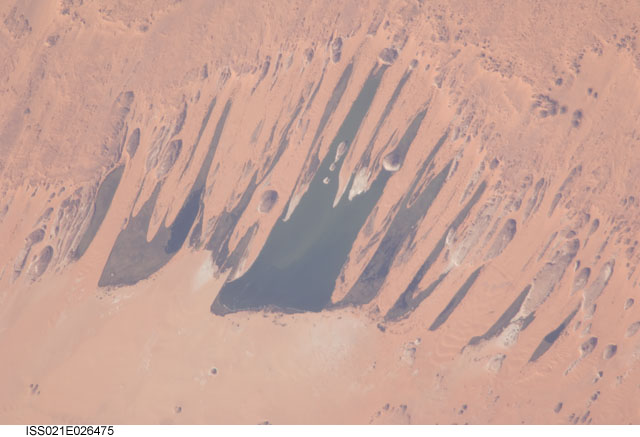
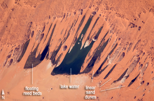
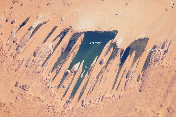
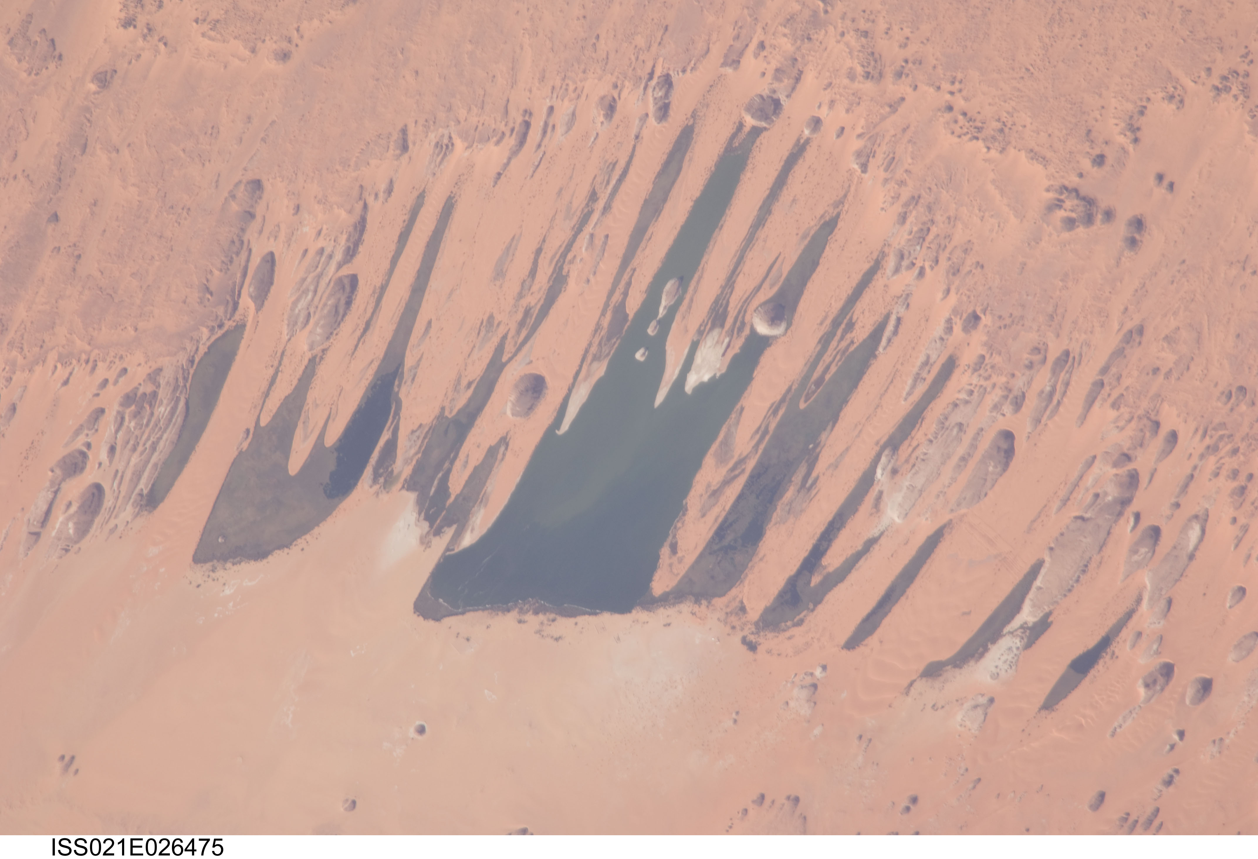
Image Caption: Ounianga Lakes, Sahara Desert, Chad
This astronaut photograph features one of the largest of a series of ten mostly fresh water lakes in the Ounianga Basin in the heart of the Sahara Desert of northeastern Chad. The lakes are remnants of a single large lake, probably tens of kilometers long, that once occupied this remote area approximately 14,800 to 5,500 years ago. As the climate dried out during the subsequent millennia, the lake shrank, and large, wind-driven sand dunes invaded the original depression, dividing it into several smaller basins.
The area shown in this image is approximately 11 by 9 kilometers. The lakes' dark surfaces are almost completely segregated by linear, orange sand dunes that stream into the depression from the northeast. The almost-year-round northeast winds and cloudless skies make for very high evaporation rates; an evaporation rate of more than 6 meters per year has been measured in one of the nearby lakes. Despite this, only one of the ten lakes is saline.
The reason for the apparent paradox--fresh water lakes in the heart of the desert--is that fresh water from a very large aquifer reaches the surface in the Ounianga Depression. The aquifer is large enough to keep supplying the small lakes with water despite the high evaporation rate. Mats of floating reeds also reduce the evaporation in places. The lakes form a hydrological system that is unique in the Sahara Desert.
The aquifer was charged with fresh water and the original lake evolved during the African Humid Period (about 14,800 to 5,500 years ago), when the West African summer monsoon was stronger than it is today. Associated southerly winds brought Atlantic moisture well north of modern limits, producing sufficient rainfall in the central Sahara to foster an almost complete savanna vegetation cover.
Pollen data from lake sediments of the original 50-meter-deep Ounianga Lake suggest to scientists that a mild tropical climate and a wooded grassland/savanna ecosystem existed in the region. Ferns grew in the stream floodplains. The same vegetation groups are now only encountered 300 kilometers farther south. Even shrubs that now occur only on the very high, cool summits (above 2,900 meters) of the Tibesti Mountains have been found in the Ounianga Lake sediments.
