ISS020-E-39932
| NASA Photo ID | ISS020-E-39932 |
| Focal Length | 80mm |
| Date taken | 2009.09.11 |
| Time taken | 22:14:27 GMT |
Resolutions offered for this image:
1000 x 649 pixels 540 x 350 pixels 720 x 480 pixels 4256 x 2913 pixels 640 x 438 pixels
1000 x 649 pixels 540 x 350 pixels 720 x 480 pixels 4256 x 2913 pixels 640 x 438 pixels


Cloud masks available for this image:
Spacecraft nadir point: 25.2° N, 55.2° E
Photo center point: 25.1° N, 55.1° E
Photo center point by machine learning:
Photo center point: 25.1° N, 55.1° E
Photo center point by machine learning:
Nadir to Photo Center: Southwest
Spacecraft Altitude: 185 nautical miles (343km)
Country or Geographic Name: | UNITED ARAB EMIRATES |
Features: | CITY OF DUBAI AT NIGHT, PALM ISLAND RESORT, PERSIAN GULF |
| Features Found Using Machine Learning: | |
Cloud Cover Percentage: | 0 (no clouds present) |
Sun Elevation Angle: | -49° |
Sun Azimuth: | 49° |
Camera: | Nikon D3 Electronic Still Camera |
Focal Length: | 80mm |
Camera Tilt: | 3 degrees |
Format: | 4256E: 4256 x 2832 pixel CMOS sensor, 36.0mm x 23.9mm, total pixels: 12.87 million, Nikon FX format |
Film Exposure: | |
| Additional Information | |
| Width | Height | Annotated | Cropped | Purpose | Links |
|---|---|---|---|---|---|
| 1000 pixels | 649 pixels | No | Yes | Earth From Space collection | Download Image |
| 540 pixels | 350 pixels | Yes | Yes | Earth From Space collection | Download Image |
| 720 pixels | 480 pixels | Yes | Yes | NASA's Earth Observatory web site | Download Image |
| 4256 pixels | 2913 pixels | No | No | Download Image | |
| 640 pixels | 438 pixels | No | No | Download Image |
Download Packaged File
Download a Google Earth KML for this Image
View photo footprint information
Download a GeoTIFF for this photo
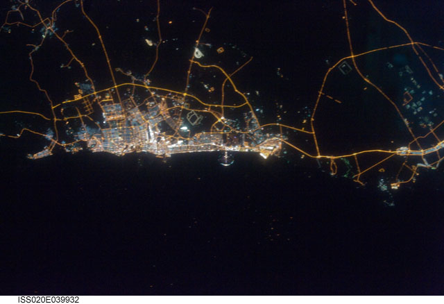
Image Caption: City of Dubai at night, United Arab Emirates
The city of Dubai is the largest metropolitan area in the emirate of Dubai, one of the member states of the United Arab Emirates. Dubai is located along the southern Persian Gulf on the Arabian Peninsula, and its signature city is known for high profile architectural and development projects. Among the most notable is the Palm Jumeirah, a man-made peninsula and surrounding islands built from over 50 million cubic meters of sand. Three other island projects, two similar to Palm Jumeirah and another crafted to look like a map of the world, are also underway along the Dubai coastline.
This nighttime astronaut photograph of the city of Dubai was taken at approximately 2 a.m. local time on September 11, 2009. Orange sodium vapor lights trace the major highways and street grid in and around the metropolitan area, while grey-white mercury vapor lamps fill in the commercial and residential areas. The lighted islands and peninsula of Palm Jumeirah are clearly visible along the coastline. A spiral pattern of lights on the southeastern fringe of the urban area is a camel racetrack. Nighttime images like these are useful to climate modelers, urban planners, and geographers as they allow for simple definition of urban (densely lit) and rural (sparely lit) areas.
