ISS014-E-19807
| NASA Photo ID | ISS014-E-19807 |
| Focal Length | 180mm |
| Date taken | 2007.04.18 |
| Time taken | 21:55:37 GMT |
Resolutions offered for this image:
1000 x 659 pixels 540 x 356 pixels 540 x 334 pixels 3032 x 2064 pixels 639 x 435 pixels
1000 x 659 pixels 540 x 356 pixels 540 x 334 pixels 3032 x 2064 pixels 639 x 435 pixels

Cloud masks available for this image:
Spacecraft nadir point: 45.4° N, 72.5° W
Photo center point: 45.5° N, 73.0° W
Photo center point by machine learning:
Photo center point: 45.5° N, 73.0° W
Photo center point by machine learning:
Nadir to Photo Center: West
Spacecraft Altitude: 171 nautical miles (317km)
Country or Geographic Name: | CANADA-Q |
Features: | MONTEREGION HILLS, AGR., GRANBY |
| Features Found Using Machine Learning: | |
Cloud Cover Percentage: | 10 (1-10)% |
Sun Elevation Angle: | 17° |
Sun Azimuth: | 268° |
Camera: | Kodak DCS760c Electronic Still Camera |
Focal Length: | 180mm |
Camera Tilt: | 10 degrees |
Format: | 3060E: 3060 x 2036 pixel CCD, RGBG array |
Film Exposure: | |
| Additional Information | |
| Width | Height | Annotated | Cropped | Purpose | Links |
|---|---|---|---|---|---|
| 1000 pixels | 659 pixels | No | Yes | Earth From Space collection | Download Image |
| 540 pixels | 356 pixels | Yes | Yes | Earth From Space collection | Download Image |
| 540 pixels | 334 pixels | Yes | Yes | NASA's Earth Observatory web site | Download Image |
| 3032 pixels | 2064 pixels | No | No | Download Image | |
| 639 pixels | 435 pixels | No | No | Download Image |
Download Packaged File
Download a Google Earth KML for this Image
View photo footprint information
Download a GeoTIFF for this photo
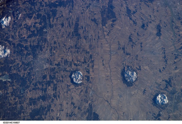
Image Caption: ISS014-E-19807 (18 April 2007) --- Monteregian Hills, Quebec, Canada are featured in this image photographed by an Expedition 14 crewmember on the International Space Station. This view captures two striking patterns, pointed out by NASA scientists who study the shuttle and station photography. The circular features are the central members of the Monteregian Hills located to the east of Montreal--Mont St. Hilaire, Rougemont, and Mont Yamaska. The rectangular pattern records the intensive agricultural land use of the fertile lowlands in southern Quebec. The Monteregian Hills are an isolated series of roughly east-west trending plutons--masses of igneous rock that crystallized below the land surface--located near Montreal. According to the scientists, magmas forming the Hills were intruded into pre-existing sedimentary rocks during the Cretaceous Era (roughly 123-125 million years ago). Over time, the sedimentary rock has eroded away, leaving the more resistant igneous rock of the plutons exposed as the Monteregian Hills in the surrounding flat St. Lawrence Plains. Rocks of these three plutons record a transition from silica-poor magmas (little to no minerals such as quartz or feldspar) to silica-rich magmas (abundant quartz and feldspar) along the line of the Hills. Snow cover on the three mountains provides additional contrast with surrounding tan to brown fallow agricultural fields. The city of Granby, Quebec is visible at left. In addition to their interesting geology, the Monteregian Hills also serve as important woodland habitat "islands" in the greater Montreal urban area.
Monteregian Hills, Quebec, Canada:
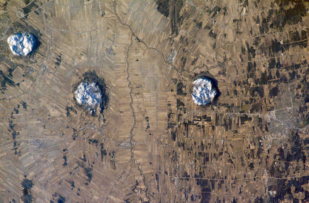
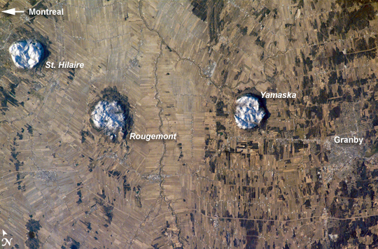
This astronaut photograph of the area to the east of Montreal, Canada, captures two striking patterns. The circular features are the central members of a group of unusual rock formations known as the Monteregian Hills: Mont St. Hilaire, Rougemont, and Mont Yamaska. The rectangular pattern blanketing the landscape in the background reveals the intensive agriculture in the fertile lowlands in southern Quebec.
The Monteregian Hills are an isolated series of roughly east-west trending plutons, masses of igneous (formed from magma) rock that crystallized below the land surface. The magmas that form the Hills intruded into pre-existing sedimentary rocks roughly 125 to 123 million years ago, during the Cretaceous Era. Over time, the sedimentary rock has eroded away, leaving the more resistant igneous rock of the plutons exposed as the Monteregian Hills, standing over the surrounding, flat St. Lawrence Plains.
Snow cover on the three mountains provides contrast with surrounding fallow agricultural fields, which are shades of brown and tan. A bright white circle nestled on top of Mont St. Hillaire is snow-covered Lac Hertel (Hertel Lake). In addition to their interesting geology, the Monteregian Hills also serve as important woodland habitat "islands" in the greater Montreal urban area. Several small town and cities are visible in the image, appearing as purplish-gray patches. The largest in the scene is the city of Beloeil, straddling the Richelieu River west of Mont St. Hillaire.
Monteregian Hills, Quebec, Canada:
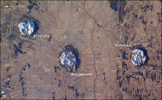
This astronaut photograph of the area to the east of Montreal, Canada, captures two striking patterns. The circular features are the central members of a group of unusual rock formations known as the Monteregian Hills: Mont St. Hilaire, Rougemont, and Mont Yamaska. The rectangular pattern blanketing the landscape in the background reveals the intensive agriculture in the fertile lowlands in southern Quebec.
The Monteregian Hills are an isolated series of roughly east-west trending plutons, masses of igneous (formed from magma) rock that crystallized below the land surface. The magmas that form the Hills intruded into pre-existing sedimentary rocks roughly 125 to 123 million years ago, during the Cretaceous Era. Over time, the sedimentary rock has eroded away, leaving the more resistant igneous rock of the plutons exposed as the Monteregian Hills, standing over the surrounding, flat St. Lawrence Plains.
Snow cover on the three mountains provides contrast with surrounding fallow agricultural fields, which are shades of brown and tan. A bright white circle nestled on top of Mont St. Hillaire is snow-covered Lac Hertel (Hertel Lake). In addition to their interesting geology, the Monteregian Hills also serve as important woodland habitat "islands" in the greater Montreal urban area. Several small town and cities are visible in the image, appearing as purplish-gray patches. The largest in the scene is the city of Beloeil, straddling the Richelieu River west of Mont St. Hillaire.
