ISS014-E-10499
| NASA Photo ID | ISS014-E-10499 |
| Focal Length | 400mm |
| Date taken | 2006.12.23 |
| Time taken | 14:57:25 GMT |
Resolutions offered for this image:
1000 x 663 pixels 540 x 358 pixels 540 x 405 pixels 3032 x 2064 pixels 639 x 435 pixels
1000 x 663 pixels 540 x 358 pixels 540 x 405 pixels 3032 x 2064 pixels 639 x 435 pixels

Cloud masks available for this image:
Spacecraft nadir point: 18.1° S, 40.3° W
Photo center point: 17.7° S, 39.2° W
Photo center point by machine learning:
Photo center point: 17.7° S, 39.2° W
Photo center point by machine learning:
Nadir to Photo Center: East
Spacecraft Altitude: 178 nautical miles (330km)
Country or Geographic Name: | BRAZIL |
Features: | STRANDPLAIN, AIRPORT, CARAVELAS |
| Features Found Using Machine Learning: | |
Cloud Cover Percentage: | 10 (1-10)% |
Sun Elevation Angle: | 83° |
Sun Azimuth: | 215° |
Camera: | Kodak DCS760c Electronic Still Camera |
Focal Length: | 400mm |
Camera Tilt: | 22 degrees |
Format: | 3060E: 3060 x 2036 pixel CCD, RGBG array |
Film Exposure: | |
| Additional Information | |
| Width | Height | Annotated | Cropped | Purpose | Links |
|---|---|---|---|---|---|
| 1000 pixels | 663 pixels | No | Yes | Earth From Space collection | Download Image |
| 540 pixels | 358 pixels | Yes | Yes | Earth From Space collection | Download Image |
| 540 pixels | 405 pixels | Yes | Yes | NASA's Earth Observatory web site | Download Image |
| 3032 pixels | 2064 pixels | No | No | Download Image | |
| 639 pixels | 435 pixels | No | No | Download Image |
Download Packaged File
Download a Google Earth KML for this Image
View photo footprint information
Download a GeoTIFF for this photo
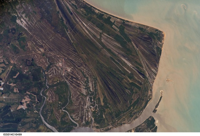
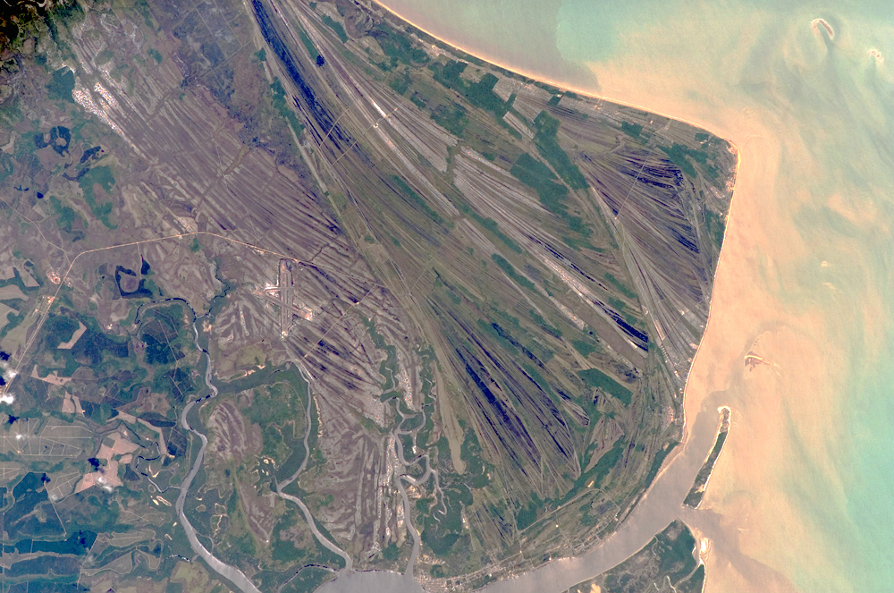
Image Caption: Caravelas Strandplain, Bahia Province, Brazil
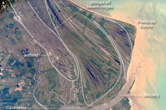
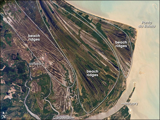
This astronaut photograph highlights an ancient shoreline, or strandplain, on the coast of Brazil. The image is dominated by numerous fine, parallel lines (trending diagonally from upper left to lower right), each of which is an ancient shoreline made up of sand transported from rivers to the north. The strandplain grew as the narrow shorelines accumulated line by line, in their dozens or even hundreds, over thousands of years. The shorelines group into "packets" with different orientations (outlined in white) that indicate their relative ages. Younger packets cut into or overlie older packets. Based on those relationships, the packet nearest the coast (farthest right) is the youngest, while the packet north of the city of Caravelas is the oldest (image bottom).
The Caravelas River flows into the Atlantic Ocean at the bottom of the view. Sediment from this river and the current shoreline produces the light browns and dun colors visible offshore. On the day the astronaut took this image, the river water was relatively clear; clear water (gray) flows out of the main river mouth and also off to one side to the south, over a levee. The Caravelas airport appears near the middle of the view, and is built on one of the ancient shoreline packets. Caravelas itself, a fishing town of about 20,000 residents, lies on an estuary and was once a flourishing whaling center--the prominent cape at image top right is known as Ponta da Baleia (Whale Point).
