ISS011-E-7471
| NASA Photo ID | ISS011-E-7471 |
| Focal Length | 400mm |
| Date taken | 2005.05.28 |
| Time taken | 19:14:49 GMT |
1977 x 1979 pixels 540 x 541 pixels 540 x 540 pixels 3032 x 2008 pixels 639 x 435 pixels

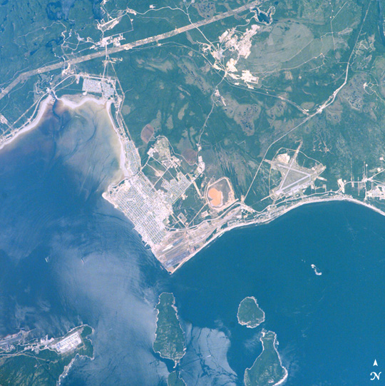


Photo center point: 50.2° N, 66.3° W
Photo center point by machine learning:
Camera: | Kodak DCS760c Electronic Still Camera |
Focal Length: | 400mm |
Camera Tilt: | 51 degrees |
Format: | 3060E: 3060 x 2036 pixel CCD, RGBG array |
Film Exposure: | |
| Additional Information | |
| Width | Height | Annotated | Cropped | Purpose | Links |
|---|---|---|---|---|---|
| 1977 pixels | 1979 pixels | No | Yes | Earth From Space collection | Download Image |
| 540 pixels | 541 pixels | Yes | Yes | Earth From Space collection | Download Image |
| 540 pixels | 540 pixels | Yes | Yes | NASA's Earth Observatory web site | Download Image |
| 3032 pixels | 2008 pixels | No | No | Not enhanced | Download Image |
| 639 pixels | 435 pixels | No | No | Download Image |
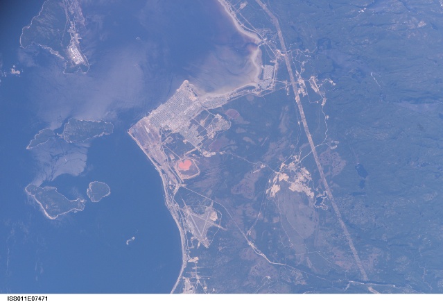
Seven Island Bay (left side of the image) is one of the largest and best-protected harbors on Quebec's north shore of the Gulf of St. Lawrence. Because this is both a deep-water port and ice-free year round, Sept-iles is one of Quebec's busiest ports. Locally produced materials (iron ore, alumina) comprise the bulk of port traffic, but Sept-iles also acts as a trans-shipment point for goods moving to Europe, the Far East, and South America.
The small city of Sept-iles (~30,000 people) appears in the center of the view; Pointe Noir is opposite the city in the lower left corner. The industrial park is at top left, and the angled runways of the airport appear east of the city. Five of the bay's seven islands appear at the bottom of the view. Wind and swells produce patterns on the water. Ships can be seen in the bay, and a ship wake appears between the two left islands at the bottom of the view.
