ISS007-E-15149
| NASA Photo ID | ISS007-E-15149 |
| Focal Length | 400mm |
| Date taken | 2003.09.21 |
| Time taken | 13:26:46 GMT |
Resolutions offered for this image:
540 x 358 pixels 999 x 662 pixels 540 x 405 pixels 1000 x 662 pixels 3032 x 2064 pixels 6144 x 4068 pixels 639 x 435 pixels
540 x 358 pixels 999 x 662 pixels 540 x 405 pixels 1000 x 662 pixels 3032 x 2064 pixels 6144 x 4068 pixels 639 x 435 pixels

Cloud masks available for this image:
Spacecraft nadir point: 26.5° S, 29.9° E
Photo center point: 26.0° S, 28.0° E
Photo center point by machine learning:
Photo center point: 26.0° S, 28.0° E
Photo center point by machine learning:
Nadir to Photo Center: West
Spacecraft Altitude: 206 nautical miles (382km)
Country or Geographic Name: | REPUBLIC SOUTH AFRICA |
Features: | JOHANNESBURG, ROADS, SUBURBS |
| Features Found Using Machine Learning: | JOHANNESBURG |
Cloud Cover Percentage: | 10 (1-10)% |
Sun Elevation Angle: | 32° |
Sun Azimuth: | 289° |
Camera: | Kodak DCS760c Electronic Still Camera |
Focal Length: | 400mm |
Camera Tilt: | 30 degrees |
Format: | 3060E: 3060 x 2036 pixel CCD, RGBG array |
Film Exposure: | |
| Additional Information | |
| Width | Height | Annotated | Cropped | Purpose | Links |
|---|---|---|---|---|---|
| 540 pixels | 358 pixels | Photographic Highlights | Download Image | ||
| 999 pixels | 662 pixels | Photographic Highlights | Download Image | ||
| 540 pixels | 405 pixels | Yes | Yes | Earth From Space collection | Download Image |
| 1000 pixels | 662 pixels | No | Yes | NASA's Earth Observatory web site | Download Image |
| 3032 pixels | 2064 pixels | No | No | Download Image | |
| 6144 pixels | 4068 pixels | No | No | Presentation | Download Image |
| 639 pixels | 435 pixels | No | No | Download Image |
Download Packaged File
Download a Google Earth KML for this Image
View photo footprint information
Download a GeoTIFF for this photo
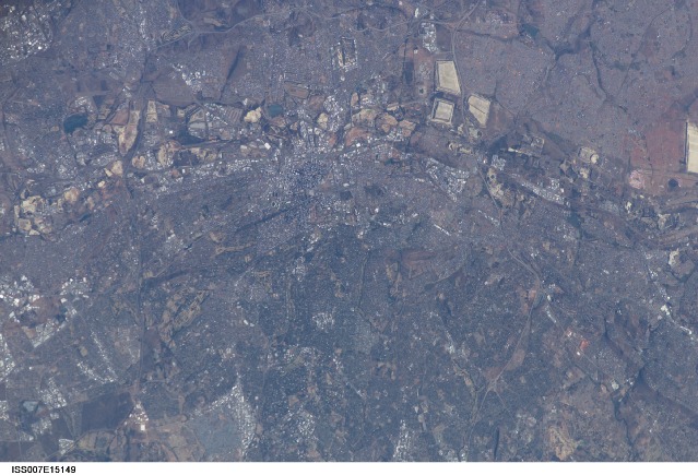
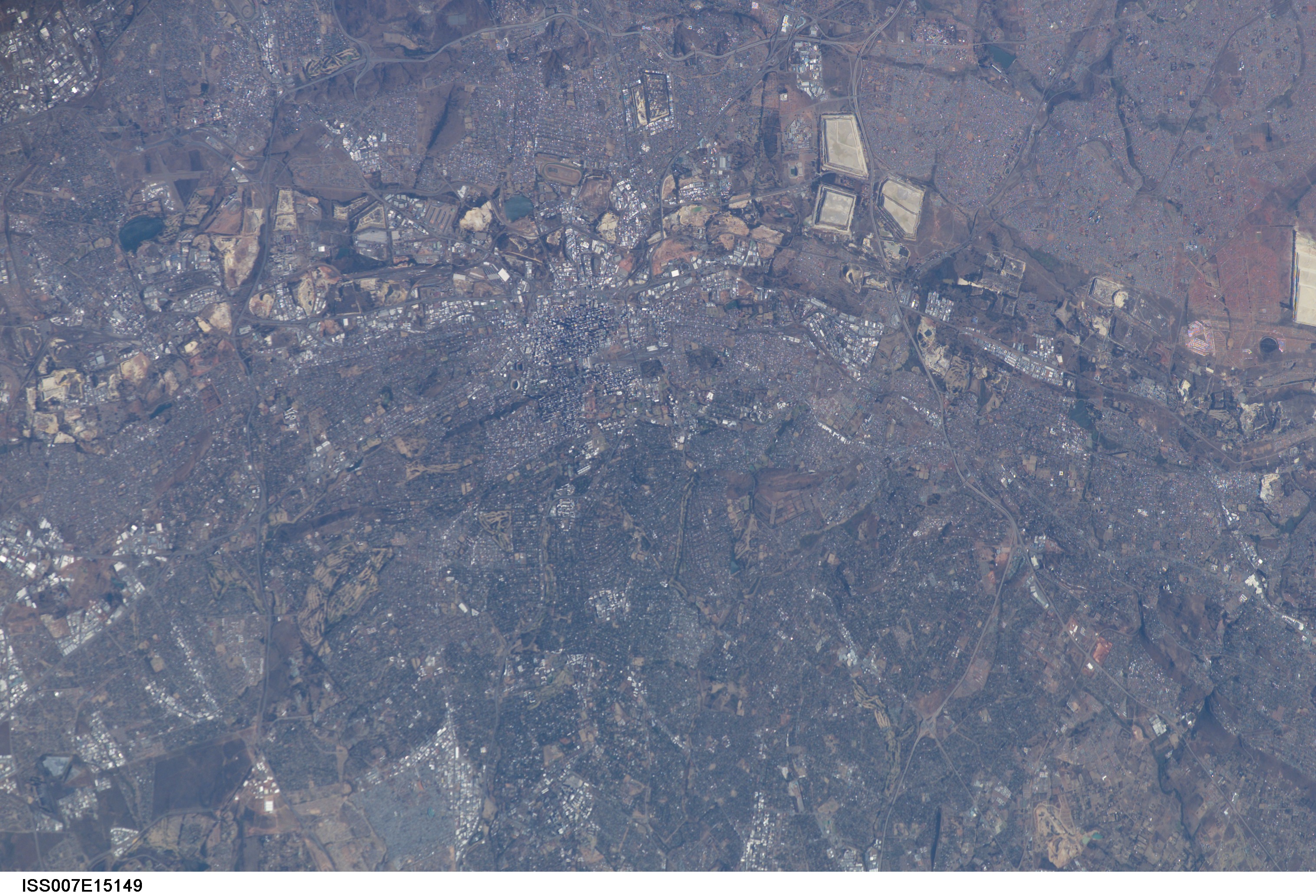
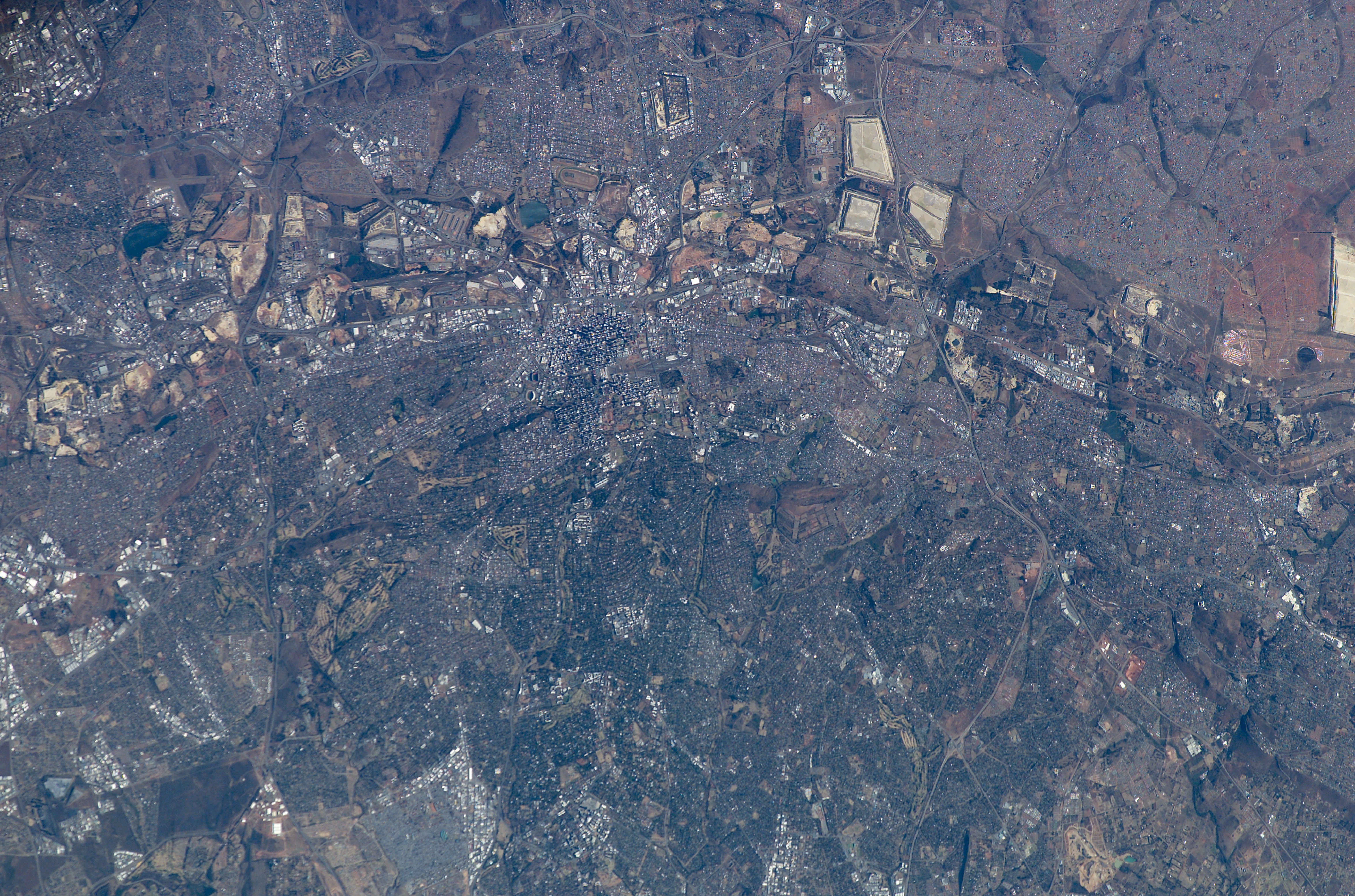
Image Caption: Johannesburg, South Africa: Why are cities established where they are? How do local economies and politics influence patterns of human settlement and development at such a grand scale that these patterns can be identified from space? This photograph of Johannesburg, South Africa, taken from the International Space Station illustrates the human geography of the region.
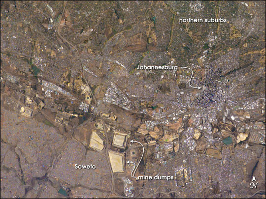
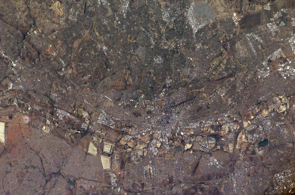
In this case, the cityscape of Johannesburg is the most difficult pattern to discern. The center of Johannesburg is the fine-grained pattern (created by shadows cast from the high rise buildings in the city) in the center of this mosaic. On the southern fringe of Johannesburg is a line of light colored, angular patches stretching across the scene. These patches are the great "mine dumps" (an example is arrowed), the crushed rock that remains after gold extraction from numerous gold mines. These are the mines that underpinned the South African economy for decades, and their dumps, or tailing piles, are the visuals that orbiting crews see when they overfly Johannesburg and neighboring cities, delineating the east-west outcrop of the gold-rich rock strata discovered in 1886. Some mine dumps are so large that an outdoor movie theater was located on one of them. Neighboring industrial cities are nestled among the mine dumps as far as the edges of the photograph. Older mine dumps nearer the Johannesburg city center have disappeared from view in the last 25 years, having been re-mined for the gold that remained within them.
The green zone (top right) is the leafy northern suburbs, where hundreds of square miles of grassland have been progressively forested since Johannesburg was founded in 1886. Small light patches within the tree-rich zone are satellite businesses and shopping centers, typical of any major western city. By contrast, a major ghetto (established by the former South African government) typical of developing-world urban migration, appears as the grey zone lower left (the famous Soweto Township). Soweto appears largely treeless except for protected valley bottoms.
