ISS007-E-14361
| NASA Photo ID | ISS007-E-14361 |
| Focal Length | 800mm |
| Date taken | 2003.09.04 |
| Time taken | 11:01:47 GMT |
Resolutions offered for this image:
1024 x 768 pixels 540 x 405 pixels 540 x 544 pixels 1000 x 886 pixels 3032 x 2064 pixels 6144 x 4068 pixels 639 x 435 pixels
1024 x 768 pixels 540 x 405 pixels 540 x 544 pixels 1000 x 886 pixels 3032 x 2064 pixels 6144 x 4068 pixels 639 x 435 pixels


Cloud masks available for this image:
Spacecraft nadir point: 17.2° S, 26.6° E
Photo center point: 18.0° S, 26.0° E
Photo center point by machine learning:
Photo center point: 18.0° S, 26.0° E
Photo center point by machine learning:
Nadir to Photo Center: Southwest
Spacecraft Altitude: 205 nautical miles (380km)
Country or Geographic Name: | ZIMBABWE |
Features: | ZAMBEZI RIVER, VICTORIA FALLS |
| Features Found Using Machine Learning: | |
Cloud Cover Percentage: | 10 (1-10)% |
Sun Elevation Angle: | 63° |
Sun Azimuth: | 333° |
Camera: | Kodak DCS760c Electronic Still Camera |
Focal Length: | 800mm |
Camera Tilt: | 16 degrees |
Format: | 3060E: 3060 x 2036 pixel CCD, RGBG array |
Film Exposure: | |
| Additional Information | |
| Width | Height | Annotated | Cropped | Purpose | Links |
|---|---|---|---|---|---|
| 1024 pixels | 768 pixels | Photographic Highlights | Download Image | ||
| 540 pixels | 405 pixels | Photographic Highlights | Download Image | ||
| 540 pixels | 544 pixels | Yes | Yes | Earth From Space collection | Download Image |
| 1000 pixels | 886 pixels | No | Yes | NASA's Earth Observatory web site | Download Image |
| 3032 pixels | 2064 pixels | No | No | Download Image | |
| 6144 pixels | 4068 pixels | No | No | Presentation | Download Image |
| 639 pixels | 435 pixels | No | No | Download Image |
Download Packaged File
Download a Google Earth KML for this Image
View photo footprint information
Download a GeoTIFF for this photo
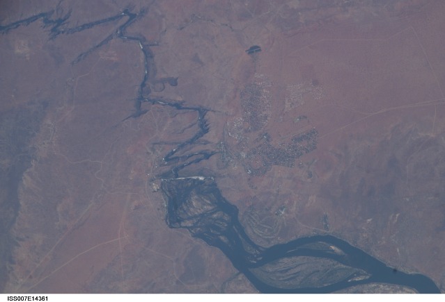
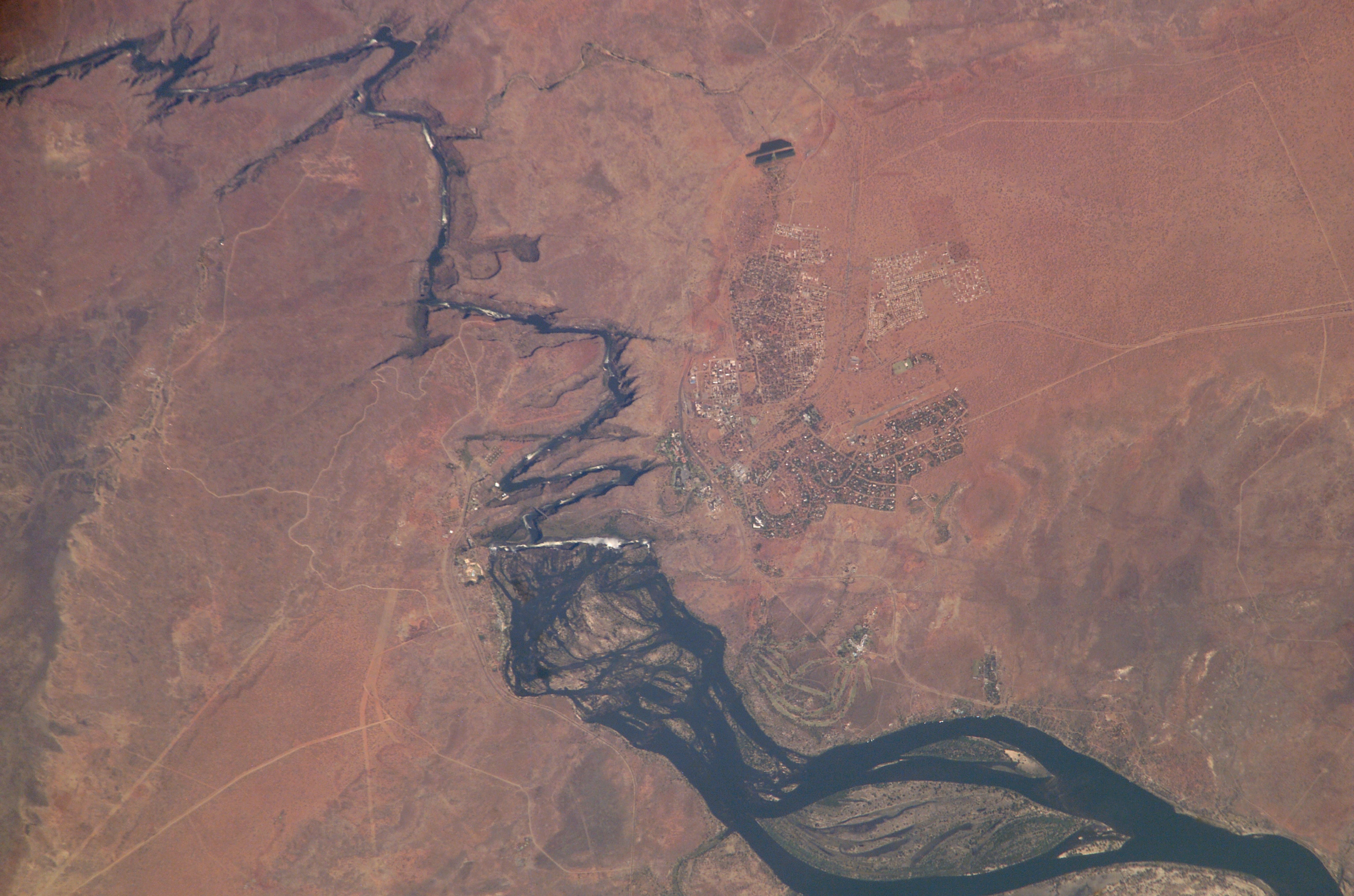
Image Caption: Victoria Falls, Zambezi River: Victoria Falls is one of the most famous tourist sites in subsaharan Africa. Details of the Falls are visible in this image taken with the 800 mm lens by Astronaut Edward Lu from the Space Station on September 4, 2003.
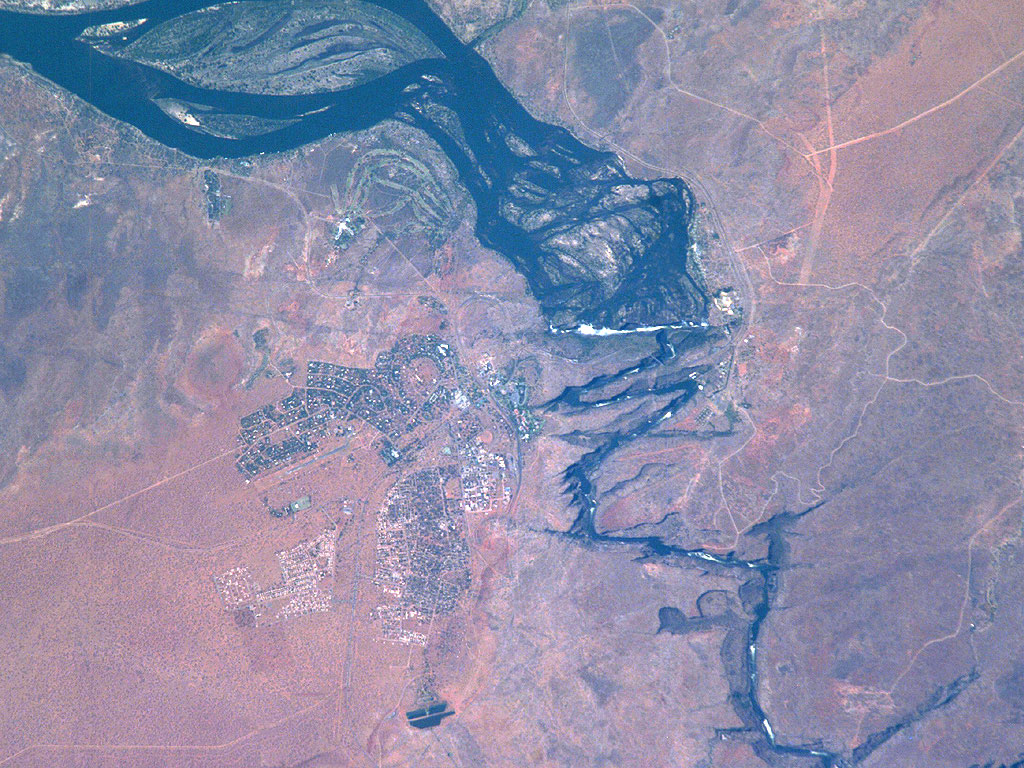
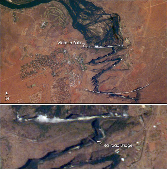
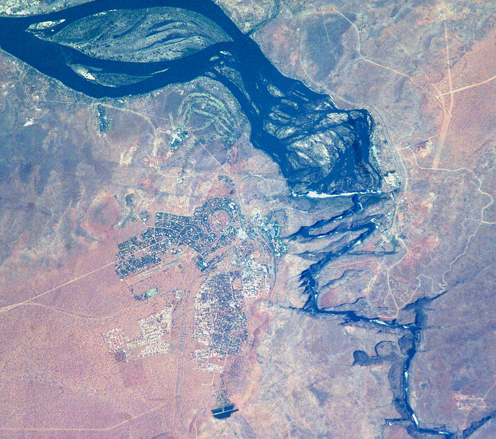
A major river in south-central Africa, the Zambezi River flows from western Zambia to the Indian Ocean in Mozambique. In the sector imaged here, it flows southeast (top left to bottom right) in a wide bed before plunging suddenly 130 meters over the Victoria Falls into a narrow gorge. The falls and their famous spray clouds are 1700 m long, the longest sheet of falling water in the world. The falls appear as a ragged white line. The small town of Victoria Falls in Zimbabwe appears just west (left) of the falls, with smaller tourist facilities on the east bank in Zambia. The international railroad bridge over the second gorge (between Zimbabwe and Zambia) can be seen in the detailed view on the bottom (arrow).
The positions of the falls are controlled by linear fault lines in the underlying basalt rocks. The falls have moved upstream (bottom to top) by intense river erosion, elongating the zig-zag gorge in the process. Prior positions of the strongly linear falls can be detected. The earliest on this cropped view may have been the longest (dashed line). The zig-zags represent subsequent positions, all with the characteristic water-worn lip on the upstream side. The falls will continue to erode northward.
