ISS005-E-6997
| NASA Photo ID | ISS005-E-6997 |
| Focal Length | 800mm |
| Date taken | 2002.07.06 |
| Time taken | 20:21:02 GMT |
Resolutions offered for this image:
539 x 360 pixels 540 x 405 pixels 1000 x 681 pixels 3032 x 2064 pixels 639 x 435 pixels
539 x 360 pixels 540 x 405 pixels 1000 x 681 pixels 3032 x 2064 pixels 639 x 435 pixels


Cloud masks available for this image:
Spacecraft nadir point: 2.9° S, 93.3° W
Photo center point: 0.5° S, 91.5° W
Photo center point by machine learning:
Photo center point: 0.5° S, 91.5° W
Photo center point by machine learning:
Nadir to Photo Center: Northeast
Spacecraft Altitude: 214 nautical miles (396km)
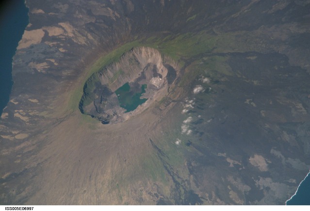
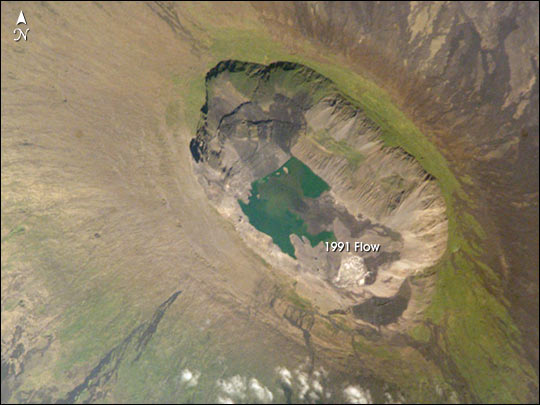
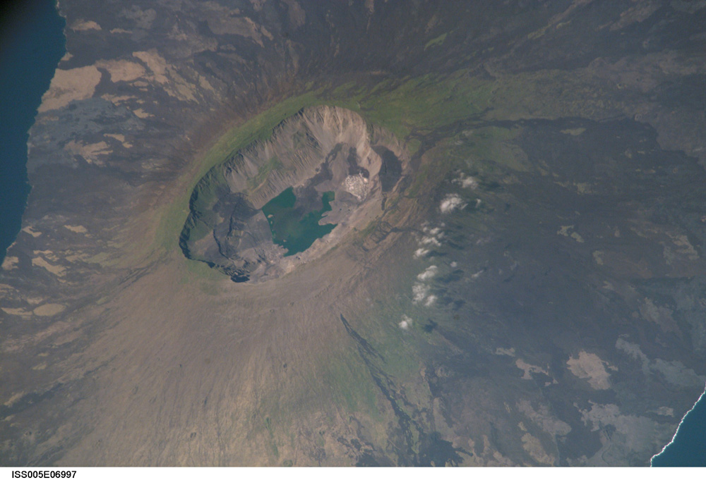
Country or Geographic Name: | GALAPAGOS ISLANDS |
Features: | LA CUMBRE VOLCANO, FERNANDINA |
| Features Found Using Machine Learning: | |
Cloud Cover Percentage: | 10 (1-10)% |
Sun Elevation Angle: | 51° |
Sun Azimuth: | 312° |
Camera: | Kodak DCS760c Electronic Still Camera |
Focal Length: | 800mm |
Camera Tilt: | 40 degrees |
Format: | 3060E: 3060 x 2036 pixel CCD, RGBG array |
Film Exposure: | |
| Additional Information | |
| Width | Height | Annotated | Cropped | Purpose | Links |
|---|---|---|---|---|---|
| 539 pixels | 360 pixels | Photographic Highlights | Download Image | ||
| 540 pixels | 405 pixels | Yes | Yes | Earth From Space collection | Download Image |
| 1000 pixels | 681 pixels | No | No | NASA's Earth Observatory web site | Download Image |
| 3032 pixels | 2064 pixels | No | No | Public Affairs Office (PAO) | Download Image |
| 639 pixels | 435 pixels | No | No | Download Image |
Download Packaged File
Download a Google Earth KML for this Image
View photo footprint information
Download a GeoTIFF for this photo
Image Caption: La Cumbre volcano on Fernandina Island is the most active volcano on the Galapagos, erupting most recently in 1995. The volcano rises 1495 m from sea level. This photo was taken by the Expedition 5 crew aboard the International Space Station. The scene provides a detailed view of the 850-m-deep summit caldera. The dark flows in the middle of the caldera floor were erupted in 1991. Today, these flows are partly covered by dark green vegetation.
