ISS003-E-6061
| NASA Photo ID | ISS003-E-6061 |
| Focal Length | 180mm |
| Date taken | 2001.09.25 |
| Time taken | 17:19:31 GMT |
Resolutions offered for this image:
1024 x 679 pixels 540 x 358 pixels 540 x 405 pixels 3060 x 2092 pixels 640 x 437 pixels 400 x 300 pixels
1024 x 679 pixels 540 x 358 pixels 540 x 405 pixels 3060 x 2092 pixels 640 x 437 pixels 400 x 300 pixels


Cloud masks available for this image:
Spacecraft nadir point: 50.5° S, 69.1° W
Photo center point: 49.0° S, 74.0° W
Photo center point by machine learning:
Photo center point: 49.0° S, 74.0° W
Photo center point by machine learning:
Nadir to Photo Center: West
Spacecraft Altitude: 214 nautical miles (396km)
Country or Geographic Name: | CHILE |
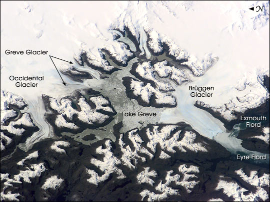
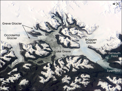
Features: | BRUGGEN GLACIER, EYRE FJORD |
| Features Found Using Machine Learning: | |
Cloud Cover Percentage: | 10 (1-10)% |
Sun Elevation Angle: | 40° |
Sun Azimuth: | 343° |
Camera: | Kodak DCS460 Electronic Still Camera |
Focal Length: | 180mm |
Camera Tilt: | High Oblique |
Format: | 3060E: 3060 x 2036 pixel CCD, RGBG array |
Film Exposure: | |
| Additional Information | |
| Width | Height | Annotated | Cropped | Purpose | Links |
|---|---|---|---|---|---|
| 1024 pixels | 679 pixels | Photographic Highlights | Download Image | ||
| 540 pixels | 358 pixels | Photographic Highlights | Download Image | ||
| 540 pixels | 405 pixels | Yes | Yes | Earth From Space collection | Download Image |
| 3060 pixels | 2092 pixels | No | No | Download Image | |
| 640 pixels | 437 pixels | No | No | Download Image | |
| 400 pixels | 300 pixels | No | No | Download Image |
Download Packaged File
Download a Google Earth KML for this Image
View photo footprint information
Download a GeoTIFF for this photo
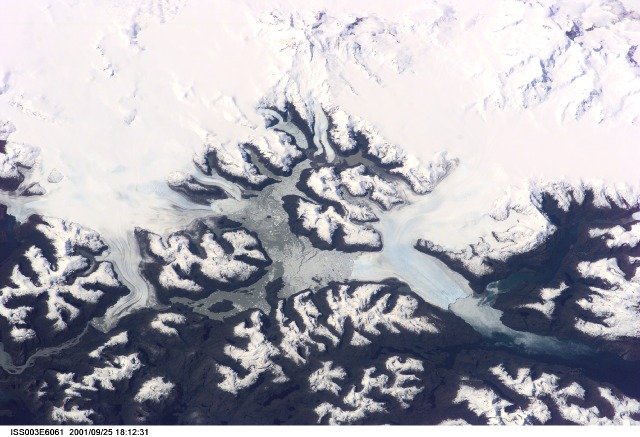
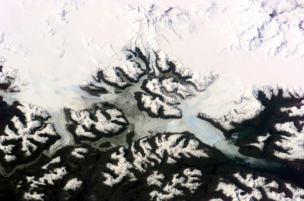
Image Caption: The Expedition 3 crew of the International Space Station caught a rare glimpse of the massive ice fields and glaciers of Patagonia early in the afternoon on September 25, 2001. This part of the South American coast sees frequent storms and is often obscured from view by cloud cover.
Bruggen Glacier in southern Chile is the largest western outflow from the Southern Patagonian Ice Field and, unlike most glaciers worldwide, advanced significantly since 1945. From 1945 to 1976, Bruggen surged 5 km across the Eyre Fjord, reaching the western shore by 1962 and cutting off Lake Greve from the sea. The glacier continued advancing both northward and southward in the fjord to near its present position before stabilizing. The growth covers a distance of more than 10 km north to south, adding nearly 60 square km of ice.
Bruggen Glacier in southern Chile is the largest western outflow from the Southern Patagonian Ice Field and, unlike most glaciers worldwide, advanced significantly since 1945. From 1945 to 1976, Bruggen surged 5 km across the Eyre Fjord, reaching the western shore by 1962 and cutting off Lake Greve from the sea. The glacier continued advancing both northward and southward in the fjord to near its present position before stabilizing. The growth covers a distance of more than 10 km north to south, adding nearly 60 square km of ice.
